
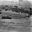
The Chesters, Drem


Pit Alignment(S) (Prehistoric)
Site Name The Chesters, Drem
Classification Pit Alignment(S) (Prehistoric)
Canmore ID 56326
Site Number NT57NW 51
NGR NT 50560 78338
NGR Description From NT 505 783 to NT 509 784
Datum OSGB36 - NGR
Permalink http://canmore.org.uk/site/56326


- Council East Lothian
- Parish Athelstaneford
- Former Region Lothian
- Former District East Lothian
- Former County East Lothian
Project (September 2012)
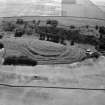
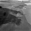
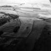
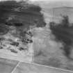
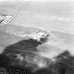
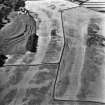
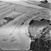
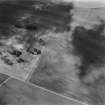
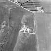
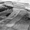
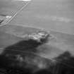
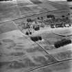
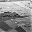
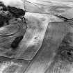
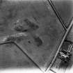
NT 504 782 – NT 506 784 (approx) The Chesters, Drem (SAM 90072) is one of the best preserved Iron Age hillforts in Scotland and is protected both by scheduling and as a PIC. However, the upstanding remains form just one element of an extensive Iron Age landscape evidenced by cropmarks identified through many years of aerial survey. Most notably, these comprise an extensive series of pit alignments which appear to reflect a cohesive system of land division potentially extending up to 5km2, and reaching as far as neighbouring hillforts at Kae Heughs (NT57NW 23) and Hanging Craig (NT57NW 89). Our project involves geophysical evaluation of these landscapes using a range of integrated and complementary techniques including standard fluxgate gradiometry and earth resistance survey. We also trialled two novel techniques currently under development and not previously used to any extent in Scotland: electrical resistivity tomography and electromagnetic survey. Gradiometry was used as the baseline technique to recover broad scale information and give wide coverage across the sites, with other techniques being used in targeted areas based on initial results and detailed field inspection.
Results from work in September 2012 were generally positive and identified the cropmark features in most areas. Several new features have been identified, including at least one probable barrow, but more significant perhaps is the new data retrieved relating to the micro-topography of the pit alignment systems and the detailed relationships between these archaeological features and the local geology.
Archive: RCAHMS (intended). Reports: East Lothian SMR and RCAHMS (intended)
Funder: Historic Scotland
Ian Armit, University of Bradford
Chris Gaffney,
Tom Sparrow,
Finn Pope-Carter,
2012
Magnetometry (September 2012)
NT 504 782 – NT 506 784 (approx) The Chesters, Drem (SAM 90072) Fluxgate gradiometry was used to investigate this extensive Iron Age landscape.
Archive: RCAHMS (intended). Reports: East Lothian SMR and RCAHMS (intended)
Funder: Historic Scotland
Ian Armit, University of Bradford
Chris Gaffney,
Tom Sparrow,
Finn Pope-Carter,
2012
Electromagnetic (September 2012)
NT 504 782 – NT 506 784 (approx) The Chesters, Drem (SAM 90072) Electromagnetic survey techniques were used to investigate this extensive Iron Age landscape.
Archive: RCAHMS (intended). Reports: East Lothian SMR and RCAHMS (intended)
Funder: Historic Scotland
Ian Armit, University of Bradford
Chris Gaffney,
Tom Sparrow,
Finn Pope-Carter,
2012
Resistivity (September 2012)
NT 504 782 – NT 506 784 (approx) The Chesters, Drem (SAM 90072) Earth resistance survey and electrical resistivity tomography techniques were used to investigate this extensive Iron Age landscape.
Archive: RCAHMS (intended). Reports: East Lothian SMR and RCAHMS (intended)
Funder: Historic Scotland
Ian Armit, University of Bradford
Chris Gaffney,
Tom Sparrow,
Finn Pope-Carter,
2012
Archaeological Evaluation (20 September 2014)
This report presents the results of an archaeological investigation undertaken by AOC Archaeology Group within the Scheduled Monument of Dalvreck at Davreck Farm near Athelstaneford, East Lothian (NGR: NT 50533 78307). The investigation consisted of the hand excavation of a one metre square test pit within the footprint of a proposed pole re-instatement. The excavation revealed 0.25 m of active plough soil overlying a glacial colluvium ranging between 0.40 m to 0.50 m in depth. An older soil deposit was present within the eastern third of the pit, 0.15 m in depth. No archaeologically significant material was observed. No further works are considered necessary.
Information from OASIS ID: aocarcha1-192780 (R Engl) 2014
Note (29 September 2022)
The location, classification and period of this site have been reviewed.
Aerial Photographic Interpretation (29 September 2022)
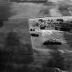
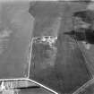
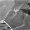
This pit alignment had been recorded as cropmarking on oblique aerial photographs (RCAHMSAP 1978; 1980) on level ground about 100m NW of The Chesters Fort (NT57NW 1). It extends from ENE to WSW from NT 50629 78362 for about 75m before turning to the SW and extending for a further 100m. It abuts pit alignment NT57NW 52 at its E end and forms part of a series of pit alignments, probably representing prehistoric land divisions, around The Chesters fort.
Information from HES Archaeological Survey (F. Vermeij) 29 September 2022

