
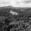
Old Melrose


Earthwork (Period Unassigned), Vallum (Early Medieval)(Possible)
Site Name Old Melrose
Classification Earthwork (Period Unassigned), Vallum (Early Medieval)(Possible)
Canmore ID 55629
Site Number NT53SE 21
NGR NT 5850 3403
Datum OSGB36 - NGR
Permalink http://canmore.org.uk/site/55629


- Council Scottish Borders, The
- Parish Melrose
- Former Region Borders
- Former District Ettrick And Lauderdale
- Former County Roxburghshire
NT53SE 21 5850 3403
(NT 5850 3403) Earthwork (NR)
OS 6" map (1967)
NMRS REFERENCE
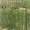
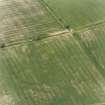
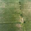
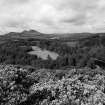
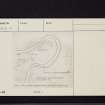
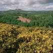
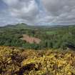
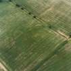
Linear Earthwork, Old Melrose: Some 350 yds W of Old Melrose the private road from the highway at Old Melrose Lodge swings towards the SSE, an unmetalled wood-road continuing its previous line along the crest of the steep river bank. From a point 45 yds E of the fork a ditch-and-bank earthwork descends the slope and ends at the water's edge; its length is about 80 yds, but on the slope it proved unmeasurable. The bank is spread to a greatest breadth of 12 ft, and is up to 4 ft in height; the ditch, which is on the W side of the bank, varies greatly from place to place in its state of preservation. Above the wood-road the work had evidently been destroyed by rig cultivation before trees were planted. RCAHMS 1956, visited 1951
EXTERNAL REFERENCE:
ORDNANCE SURVEY
NT 5852 3400 - NT 5848 3405. This earthwork is generally as described above. The bank is about 3.0 m broad and 1.0 m maximum height, the ditch being 2.5 m in average width. The earthwork is cut by a footpath about 40.0 m below the wood-road, and there are traces of a ditch on the E side of the bank, extending from a few metres above this footpath to the end of the work some 6.0 m from the water's edge on the steep river bank.
Surveyed at 1:2500.
Visited by OS (WDJ) 14 February 1961
EXTERNAL REFERENCE:
C. THOMAS
This earthwork is identified by Thomas as the vallum of the monastery of 'Mailros'. He states that it can be traced practically all across the peninsula, at its narrowest point. It appears more of a wide, broad ditch between two banks, an inner bank and an outer counter-scarp, both pretty well spread. The entrance, about the middle of the wall, is known to Mr Moffat, tenant. It preceded the present layout of the drive, and its line is marked by a high natural ridge, on which lay some sort of cobbled or made road which is still detectable in ploughing.
C Thomas 1971; Information from a letter from C Thomas 21 March 1961
EXTERNAL REFERENCE:
A. MILNE
Milne states that a house, called the Redhouse stood at the entrance; unless it lay in the present wood, it may be in the area just inside the vallum by the entrance detectable on the air photographs (106G.Scot.UK 18: 5121-2).
A Milne 1743
EXTERNAL REFERENCE:
I.B. COWAN AND D.E. EASSON
The monastery at Old Melrose was possibly founded from Iona during the episcopate of Aidan between 635 and 651; Drythelm, an ascetic, became a monk in a separate dwelling at Melrose at the end of the 7th century. The monastery was burned down by Kenneth MacAlpin in 839, but according to a 12th century account which incorporates earlier source material, the monastery survived in 854 as a foundation pertaining to the bishops of Lindisfarne, one of whom, Edilwald, is credited as abbot of Melrose in 746 in a treatise on the Benedictine order.
The monastery was deserted in 1074 when an attempt by Aldwin of Jarrow to restore it for Benedictine monks failed. It was succeeded by a chapel dedicated to St Cuthbert (see NT53SE 23).
I B Cowan and D E Easson 1976
EXTERNAL REFERENCE:
CUCAP
Photographed by CUCAP.
Sbc Note
Visibility: This is an upstanding earthwork or monument.
Information from Scottish Borders Council

