
Hawthorndene


Settlement (Prehistoric)
Site Name Hawthorndene
Classification Settlement (Prehistoric)
Canmore ID 147336
Site Number NT53SE 159
NGR NT 5889 3090
Datum OSGB36 - NGR
Permalink http://canmore.org.uk/site/147336


- Council Scottish Borders, The
- Parish St Boswells
- Former Region Borders
- Former District Ettrick And Lauderdale
- Former County Roxburghshire
NT53SE 159 5889 3090
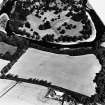
The cropmark of a rectilinear settlement have been revealed by oblique aerial photography (RCAHMSAP 1995) immediately SW of Hawthorndene Garage. The settlement measures about 90m to 100m NW-SE by 40m to 50m transversely and there is a possible entrance on the NE side. The cropmarks on the SE side of the settlement are very indistinct.
Information from RCAHMS (KJ) 13 July 1999.
Archaeological Evaluation (September 2017)
NT 589 309 A 10% evaluation was undertaken, September
2017, in advance of a proposed development. A rectilinear
enclosure identified in aerial photographs was confirmed as
surviving and conforming to the general plan as shown on
the aerial photograph. A number of sections were excavated
through the ditch, and it was found to be 1.8–5.0m wide
and up to 1.7m deep. The only finds recovered from its
fills were animal bone. The entire enclosure measured 87
x 51m. Where recorded, the corners were rounded and the
enclosure’s entrance is postulated to lie on the SE side.
No features were recorded within the interior of the
enclosure, but a group of features were uncovered external
to the entrance on the SE side. These included two linear
features, two possible postholes and eight pits around the
possible entrance. The only other feature recorded was
an isolated pit to the W of the site. The characteristics of
the ditch and the shape of the enclosure suggest that the
enclosure is probably Iron Age in date.
Archive: NRHE (intended). Reports: Scottish Borders HER
Funder: Border Motor Group
Gary Savory – CFA Archaeology Ltd
(Source: DES, Volume 19)
Aerial Photographic Transcription (5 August 2019)
An interpretative transcription, or mapping, of information on oblique aerial photographs was produced on 5 August 2019.
Sbc Note
Visibility: This site is visible as a cropmark.
Information from Scottish Borders Council

