
Kincraig Battery


Gun Emplacement(S) (20th Century)
Site Name Kincraig Battery
Classification Gun Emplacement(S) (20th Century)
Alternative Name(s) Forth Defences
Canmore ID 271440
Site Number NT49NE 44.02
NGR NT 46820 99911
NGR Description NT 46725 99909, NT 46820 99911 and NT 46862 99961
Datum OSGB36 - NGR
Permalink http://canmore.org.uk/site/271440


- Council Fife
- Parish Elie
- Former Region Fife
- Former District North East Fife
- Former County Fife
NT49NE 44.02 46725 99909, 46820 99911 and 46862 99961
Gun-emplacements for two 6-inch Mk VII/II guns, installed in 1939 and replaced in 1942 by Mk VII/v guns. The battery was again altered in 1943 with the earlier 6-inch guns being replaced by three 6-inch Mk XXIV/v guns, these being removed in 1956.
The gun-emplacements are visible on vertical air photographs (106G/Scot/UK 4, Part II, 6165-7, flown 14 April 1946) which show the three large gun brick and concrete positions (also depicted on the OS 1:10000 scale map (1987), two with guns can still be seen mounted on the photographs.
Information from RCAHMS (DE), March 2005 and J Guy 1993
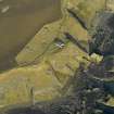
The three gun-emplacements have been partially demolished. Only the gun pit and holdfast survives intact, the superstructure having been flattened and reduced to a pile of concrete and brick rubble.
Visited by RCAHMS (DE), 16 May 2007
Field Visit (10 November 2023)
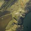
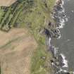
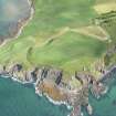
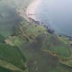
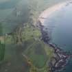
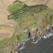
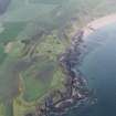
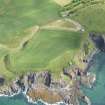
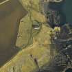
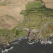
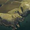
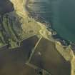
The grass- and shrub-grown remains of three part-sunken gun emplacements are situated above the cliffs on Kincraig Hill in an arc up to 140m apart. They were constructed by the army during the Second World War and blown up following their decommissioning in 1956. All are of the same general design and partly sunken into the ground, comprising a gun house with an open gun pit facing out to sea and an L-shaped crew shelter to the rear. While the SW and central emplacements share the same ground plan, the NE emplacement is a mirror image of its neighbours. Each was served by four magazines situated nearby to their N. These extend in a line from NE to SW and are linked by both a trench system and a later terraced track.
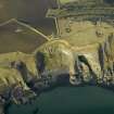
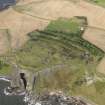
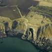
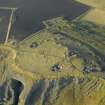
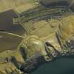
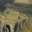
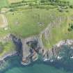
The NE emplacement (No.3) is the best preserved and is situated less than 4m from the cliff edge. It measures about 23m from NW to SE by 18m transversely overall. its outer camouflaged apron of rough cast-concrete artificial rocks is 3m broad, while the gun pit measures 7.5m in diameter and up to 1.7m in depth. This contains a central holdfast measuring 2.3m in diameter with at least 28 bolts visible around its circumference. A grass-grown duct runs SW from its centre disappearing under the downward sloping floor at the pit’s entrance. An encircling gutter at the foot of the pit’s wall is also filled by grass. The gun floor around the NW arc of the pit measures 1.5m in thickness and 1.65m in height. It preserves not only the sawn-off stumps of the metal railings that ran around its outer perimeter, but also the bolt settings that fixed the uprights for the gun house roof. Narrow rebates either side of the entrance gap in the surface of the gun floor indicate that there was a removeable metal plate covering a break in the walkway. The wing walls extending the gun floor NE and SW survive, with the former leading to the remains of a flight of steps to the gun house. Here are seven ammunition lockers in the outer wall of the pit, each measuring 1.07m in width by 0.9m in height and 1.1m in depth. Their outer edges have been rebated and there are hinges for doors each side. There were at least four similar severely damaged lockers facing them on the opposing rear wall of the gun house. Immediately WNW of the SW wing wall of the pit is a rectangular outshot. This had a flat roof and a tall entrance accessed from the gun house, while the walls retain the remnants of metal fittings and a shallow rectangular indent on the SW close to the concrete floor. There are cable ducts set in the latter and it is possible that this compartment contained electrical equipment. The flat bitumen-clad roof of this compartment has collapsed along with the rear wall of the gun house, but the gun house’s roof appears to have been deliberately removed (thus leaving no debris) and only its side walls largely survive. The gun house was rectangular on plan and measured about 15m from NE to SW by 7m transversely within concrete walls varying between 0.31m - 0.62m in thickness that rose perhaps to about 3m in height. Enough survives to indicate that there was a tall central entrance in the NW wall with broad entrances at both of its corners and that a bitumen finish covered the concrete floor. All that remains of the crew shelter are the remains of its concrete floor which indicates that it was L-shaped on plan with the main compartment measuring 10.4m from NE to SW by 4.4m transversely within walls 0.6m in thickness and up to 2.5m in height. The debris indicates that there was a central window in the NE and SW walls – the latter retaining traces of camouflage paint on its outer face. In addition, a pair of ceramic pipes for cables can be observed emerging at the SE corner. The outshot on its NW measured 4.3m from NE to SW by 3.1m transversely. The NW corner of the gun emplacement is approached by a grass and bramble-grown trench that not only provided access to the magazines situated to the N, but also to the rest of the trench system linking it with the command post and most of the other magazines. However, the SE end of the trench shallows before reaching the emplacement and is covered by debris. Access to the single magazine situated to the NE beyond the water tank (NT49NE 44.13) could be had at ground level.
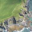
The central gun emplacement (No.2) is situated about 45m SW of its neighbour to the NE and 12m from the cliff top. The damage it has sustained is more severe. Although it is orientated from NNW to SSE, it otherwise varies only in minor respects. One striking difference is the addition of a series of neatly engraved numerals picked out in bitumen around the SSE edge of the gun platform. These read from WSW to ENE: -25/-50, -50/-50, -50/-25, while 0 is denoted adjacent to the SSE edge of the entrance. They may represent bearings. Much of the debris associated with the gun house and the crew shelter is obscured by a thick blanket of cotoneaster. However, the shelter not only contained a window in the WSW wall, but another in the NNW wall. The access trench approaching the NW corner of the emplacement is much longer than the branch leading to its NE neighbour, as the magazines are more distant. Although it is partly silted, it has been completely infilled where it is crossed by the footpath adjacent to the fence. An open inspection pit covered by a thin metal mesh situated 4m SW of the pit’s apron is possibly connected with the drainage of the gun emplacement towards the cliff.
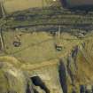
The SW gun emplacement (No.3) is situated about 75m due W and downslope from the central emplacement and 30m from the cliff top. It is the most heavily damaged of the three, but it is identical to its immediate neighbour. The pit and its apron are largely intact, but although its NNW arc can be traced, the gun floor has been badly disturbed and in places completely destroyed. The entrance to the pit is also obscured by rubble and vegetation, but the wing walls survive intact and link with the remnants of the gun house walls and the outshot on the ENE that may have contained electrical equipment. Some of the ammunition lockers under the gun floor remain, but they are all slightly displaced, while only a fragment of the crew shelter behind the gun house survives. There is a short length of a concrete path to its WSW. A grass-grown access trench with upcast to each side runs from the NE corner of the gun emplacement back to the terraced track and the more westerly magazines. There is an open drainage ditch extending from the SW corner of the emplacement to the edge of the cliff.
The three numbered gun emplacements are shown on a plan of the battery’s layout entitled ‘Secret Copy No.7’, dated ‘22.7.42’, which is included in the Fort Record Book held by the National Archives at Kew (WO192/255). Mk XXIV guns were introduced to emplacements Nos.1 and 2 in May 1942, while 3 was kept in reserve and unarmed. These were replaced by Mk XXIV guns in April 1943 (Barclay and Morris 2019, 215-22). The emplacements are clearly shown under camouflage on an oblique aerial photograph taken from the NW on 14 August 1943 (M/042/NLA/067 0016). By contrast, vertical aerial photographs (106G/Scot /UK-0004 6163;58/RAF/1263/F22-0241) flown on 14 April 1946 and 8 September 1953 show the emplacements stripped of their camouflage, but with the two guns still in place. They also show the less formal network of trackways and paths that had developed between them. Another aerial photograph (FSL/7343/13/0791) flown on 13 October 1973 shows that all three emplacements had been demolished by that date. It is not clear when the W end of the trench system was slighted and replaced by the terraced track, but this photograph also shows this had occurred before 1973.
Visited by HES Archaeological Survey (A. T. Welfare, J. M. Hepher, A. K. Kilpatrick, P. M. Bethune), 10 November 2023

