
Galashiels, Kilnknowe Haugh, Mill Park, Riverside Mill


Tweed Mill (19th Century)
Site Name Galashiels, Kilnknowe Haugh, Mill Park, Riverside Mill
Classification Tweed Mill (19th Century)
Alternative Name(s) Braidhead And Graves; Buckholm Mill; Brown Brothers; Kilnknowe Haugh; Riverside Tweed Mills; Gala Water
Canmore ID 178723
Site Number NT43NE 116
NGR NT 4793 3736
NGR Description Centred NT 4793 3736
Datum OSGB36 - NGR
Permalink http://canmore.org.uk/site/178723


- Council Scottish Borders, The
- Parish Galashiels
- Former Region Borders
- Former District Ettrick And Lauderdale
- Former County Selkirkshire
NT43NE 116 centred 4793 3736
Warehouse [NAT]
OS (GIS) MasterMap, October 2009.
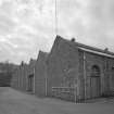
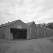
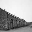
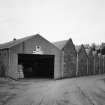
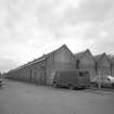
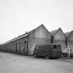
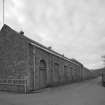
In 1884 the owners of Buckholm Mill, Brown Brothers erected a large weaving shed, covering between six and seven thousand yards in Kilnknowe Haugh, on the opposite side of the Gala Water. An iron bridge connected the various portions of Buckholm Mill on either side of the river.
R Hall 1898.
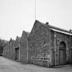
(Location cited as NT 481 373). Buckholm Mill, built 1846 for Henry Sanderson. A fine 5-storey, 4- by 20-bay whinstone rubble building with a bellcote on the S wall. On the oppsite bank of the river [apparently centred NT 4802 3737] is a large block of weaving sheds added in 1883 by Brown Bros. Lit by electricity in 1843. The tunnel lade and sluices can still be seen.
J R Hume 1976.
During March 1999, RCAHMS conducted a photographic survey of the standing industrial heritage relating to the textile industry in Galashiels. The purpose of this survey was to enhance and augment the existing holdings of the National Monuments Record Scotland.
Visited by RCAHMS (MKO), February 1999
Owing to the absence of an exact name for the weaving sheds so named Riverside Mill, in either the bibliographic texts consulted, (see Bibliography) or on the 2nd and 3rd edition Ordnance Survey plans, it would appear that this mill may have been the weaving sheds for Buckholm Mill. The reasoning for this is that Buckholm Mill is named 'Riverside tweed mills, in the book entitled 'Industrial History in Pictures", by John Butt, Ian L. Donnachie and John R Hume, on page 48.
Buckholm Mill and the weaving sheds are separated by the Gala Water, which may have been necessitated by the narrowness of the river valley at this point, but they are linked by a conveniently situated bridge, between the two at NT4800 3736.
Information from RCAHMS (DHR), January 2001.

