
Huntly Burn


Rig And Furrow (Medieval) - (Post Medieval), Settlement(S) (Period Unassigned)
Site Name Huntly Burn
Classification Rig And Furrow (Medieval) - (Post Medieval), Settlement(S) (Period Unassigned)
Canmore ID 54333
Site Number NT42SW 2
NGR NT 4077 2419
Datum OSGB36 - NGR
Permalink http://canmore.org.uk/site/54333


- Council Scottish Borders, The
- Parish Kirkhope
- Former Region Borders
- Former District Ettrick And Lauderdale
- Former County Selkirkshire
NT42SW 2 4077 2419.
(NT 40772419) FORT (NR)
OS 6" map (1900)
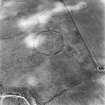
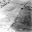
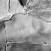
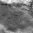
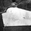
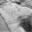
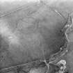
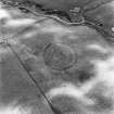
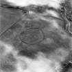
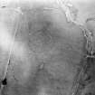
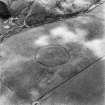
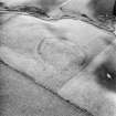
Earthwork, Huntly Burn. In a cultivated field on the left bank of the Huntly Burn, a mile due E. of Ettrickbridge End and at a height of 650ft OD, there is an oval earthwork consisting of a substantial bank and external ditch with overall measurements of 330ft from E to W by 280ft transversely.
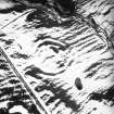
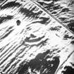
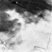
Although it may be prehistoric, the earthwork cannot properly be described as a fort since it is immediately overlooked by rising ground on both the N and W sides. The site has long been under cultivation and, as the OS map shows, the only visible remains now comprise a segment of the ditch, some 14ft wide but largely filled up, on the E side; an entrance, represented by a causeway 20ft wide through the ditch at the E. apex; and the crest and scarp of the bank on the S. The complete circuit of the ditch is, however, clearly indicated by a cropmark on National survey air-photographs (Visible on RAF 106G/SCOT/UK 86, 4433-4 and CUCAP No. DK 40) in the CUCAP, while the latter photograph suggests that the interior was subdivided by narrower crescentic ditch running from N to S in the eastern portion. There are no traces of internal buildings.
RCAHMS 1957, visited 1949
This earthwork is generally as described by RCAHMS. Contrary to the authority, however, the complete circuit of the external ditch can be traced. The interior of the work is featureless and slopes gradually towards the NW. There is no sign of the crescentic ditch subdividing the interior as suggested by RCAHMS.
Resurveyed at 1:2500.
Visited by OS (EGC) 27 June 1962
Examination of the cropmarks of this former earthwork on recent aerial photographs (RCAHMSAP 1995) has led to the re-interpretation of this site as a settlement. The 'crescentic ditch' identified from earlier photographs is part of a sub-circular enclosure, with a diameter of approximately 40m, which sits eccentrically within the settlement and intersects its W side. The cropmarks of three sides of an oval or sub-rectangular enclosure, measuring approximately 53m by at least 40m, have been recorded abutting the NE side of the settlement. The N side of this enclosure appears to have a triple ditch, and this has also been interpretated as a settlement.
Information from RCAHMS (KB) 14 July 1999
Sbc Note
Visibility: This is an upstanding earthwork or monument.
Information from Scottish Borders Council

