
Allan Water


Enclosed Settlement (Prehistoric)
Site Name Allan Water
Classification Enclosed Settlement (Prehistoric)
Canmore ID 54023
Site Number NT40NE 23
NGR NT 4670 0550
Datum OSGB36 - NGR
Permalink http://canmore.org.uk/site/54023


- Council Scottish Borders, The
- Parish Teviothead
- Former Region Borders
- Former District Roxburgh
- Former County Roxburghshire
NT40NE 23 4670 0550.
(NT 4670 0550) Earthworks (NR)
OS 25" map (1967)
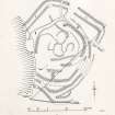
The greatly dilapidated remains of two earthworks, one within the other, lie on gently sloping ground on the right bank of the Allan Water at 700 ft OD. The manner in which the structures of successive periods have interfered with one another, as well as later disturbance and a heavy growth of vegetation, makes the interpretation of the remains uncertain, but their character may be judged from the plan. This shows a large sub-rectangular enclosure (I) which has been mutilated by cultivation, drainage, and the intrusion of an oval enclosure (II).
The former measures about 395 ft from NE to SW by about 345 ft transversely, and consists of a ditch with an earthen bank on either side of it; these features are best preserved on the NW where the inner bank is 12 ft wide and stands 1 ft above the interior and 2 1/2 ft above the bottom of the ditch, which is 12ft wide. The outer bank is spread to a width of 20 ft and stands 6 ft above the ditch bottom and 4 ft above the level of the ground outside. There is a mutilated entrance 45 ft wide in the NE end. On the W and SW the banks have been washed away by the river. A swamp has invaded the site on the E and SE, obliterating the features of this portion, and what seems to be a watercourse or an old roadway has introduced further confusion.
The oval enclosure (II) occupies most of the interior of (I). It measures about 209 ft from NE to SW by about 220 ft transversely. It is formed by a ditch with an earthen bank on either side of it, which interfere with (I) on the E. The inner bank is best preserved on the W, where it is 17 ft in width and stands 5 ft in height above the interior and 8 1/2 ft above the bottom of the ditch. The ditch is irregular and fragmentary; it is 10 ft in width on the E, where it is best preserved. The outer bank at this point is 12 ft in width, and stands to a height of 1 ft above the bottom of the ditch; the outer face is only a few inches high. The entrance may have been on the N, in line with that of (I), but it has bee destroyed by a farm-track. The NE portion of the interior is occupied by three hollow courts, but the remainder contains only swampy ground cut up by surface drains.
The outer earthwork (I) bears a strong general resemblance to NT40NE 9. RCAHMS 1956, visited 1949
These earthworks are as described, and generally as planned, by the RCAHMS.
Visited by OS (JTT) 26 February 1965
No change in condition, apart from evidence of continual river erosion on the W side of the earthworks. Their size and general construction suggests that they are multi-phased settlements, although the low, burnside location is not typical of settlements in this border area. Surveyed at 1:10,000.
Visited by OS (JRL) 23 November 1979
This site was damaged in 1984 by drainage operations and in March 1985 a trench measuring 24m NNE-SSW by 1.5m wide was opened in the N corner of the earlier enclosure in advance of further drainage work.
J S Rideout 1989
Scheduled Monument consent was granted to the landowner to permit limited land improvements. In advance of this work, a trench 24m long and 1.5m wide was opened across the outer (earlier) enclosure in the NW corner of the site. The section showed an outer bank c3m wide and c0.4m high; and inner bank c4m wide and c0.35m high and a 'V' sectioned medial ditch c5m wide and c2.5m deep. The ditch has filled naturally with silts and clays to a depth of c1.5m. Within the enclosure was a low bank c3m wide and c0.3m high, not recorded on earlier plans. Between this bank and the enclosure bank was a shallow 'V' sectioned ditch. No finds were recovered.
Sponsor : HB&M (CEU)
J S Rideout 1985
The archive from the 1985 excavations at Allan Water has been catalogued. It consists of photographic material, drawings and manuscripts.
Historic Scotland Archive Project (FD) 1999
Excavation (1985)
This site was damaged in 1984 by drainage operations and in March 1985 a trench measuring 24m NNE-SSW by 1.5m wide was opened in the N corner of the earlier enclosure in advance of further drainage work.
J S Rideout 1989
Scheduled Monument consent was granted to the landowner to permit limited land improvements. In advance of this work, a trench 24m long and 1.5m wide was opened across the outer (earlier) enclosure in the NW corner of the site. The section showed an outer bank c3m wide and c0.4m high; and inner bank c4m wide and c0.35m high and a 'V' sectioned medial ditch c5m wide and c2.5m deep. The ditch has filled naturally with silts and clays to a depth of c1.5m. Within the enclosure was a low bank c3m wide and c0.3m high, not recorded on earlier plans. Between this bank and the enclosure bank was a shallow 'V' sectioned ditch. No finds were recovered.
Sponsor : HB&M (CEU)
J S Rideout 1985
The archive from the 1985 excavations at Allan Water has been catalogued. It consists of photographic material, drawings and manuscripts.
Historic Scotland Archive Project (FD) 1999
Sbc Note
Visibility: This is an upstanding earthwork or monument.
Information from Scottish Borders Council

