
West Wemyss Harbour


Harbour (17th Century)
Site Name West Wemyss Harbour
Classification Harbour (17th Century)
Alternative Name(s) Firth Of Forth; Outer Forth Estuary
Canmore ID 54002
Site Number NT39SW 5
NGR NT 32345 94592
Datum OSGB36 - NGR
Permalink http://canmore.org.uk/site/54002


- Council Fife
- Parish Wemyss
- Former Region Fife
- Former District Kirkcaldy
- Former County Fife
NT39SW 5 32345 94592
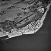
(Location cited as NT 324 946). Harbour, 19th century. Largely filled in although the main pier and the entrance to the gated basin are still intact.
J R Hume 1976.
Site recorded by Maritime Fife during the Coastal Assessment Survey for Historic Scotland, Kincardine to Fife Ness 1996
Note (21 February 2012)
Not to be confused with East Wemyss, harbour (NT 340 967), for which see NT39NW 282.

