
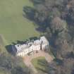
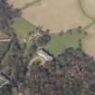
Newhailes House


Country House (17th Century), Gate Pier(S) (17th Century) - (18th Century)
Site Name Newhailes House
Classification Country House (17th Century), Gate Pier(S) (17th Century) - (18th Century)
Alternative Name(s) New Hailes; Whitehill
Canmore ID 53819
Site Number NT37SW 168
NGR NT 32687 72505
Datum OSGB36 - NGR
Permalink http://canmore.org.uk/site/53819


First 100 images shown. See the Collections panel (below) for a link to all digital images.
- Council East Lothian
- Parish Inveresk (East Lothian)
- Former Region Lothian
- Former District East Lothian
- Former County Midlothian
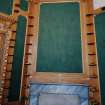
In 1686 the architect James Smith designed Newhailes House as his family home. After its purchase in 1709 by Sir David Dalrymple, William Adam was commissioned to design a new staircase and hall. Around 1750, further additions saw the construction of new wings, including a large double-height library. Newhailes is now in the care of the National Trust for Scotland who have conserved the property as an example of the evolution of a country house over centuries.
Information from RCAHMS (SC) 9 August 2007
McWilliam, C 1978
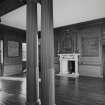
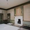
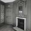
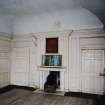
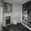
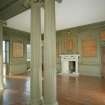
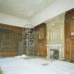
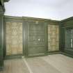
A medium sized house with a deceptively plain exterior. The centre block was built by James Smith, architect, as his own residence. At that time it was named Whitehill. In 1709 it was bought by Sir David Dalrymple and renamed after his East Lothian estate of Hailes. A partial internal refit was carried out by William Adam from c.1720, but no significant addition was made to the exterior till c.1750, the new work continuing the stone-dressed harling of the original. The flanking blocks and more interiors were completed by 1760.
C McWilliam 1978
NT 3269 7250 A major programme of monitoring, evaluation and architectural recording was undertaken at the mansion house and within its surrounding policies during conservation works between June 2000 and August 2001. The principal findings include:
Mansion house (NMRS NT37SW 168). Numerous features were recorded during reservicing throughout the mansion interiors. Some refinement of the original layout of the James Smith villa of c 1690 was achieved, particularly at basement level. A 'secret passage' was revealed that provided private access to a suite of panelled rooms at first-floor level; this had subsequently been blocked off during the installation of a dumb waiter. General analysis of the Smith period masonry fabric confirmed that it did not incorporate earlier structural remains. A detailed record was made of part of the exterior before repair and reharling works; this recorded details of the original pressed-back harl and its scheme of regular ruling-out to imitate coursed ashlar, and a number of subsequent repairs that generally employed cementitious mixes. Evidence for the original principal entrance arrangement on the NE facade was recorded beneath the existing stair; the original stair had been narrower, and had had a vaulted chamber below that led to a basement entrance, subsequently blocked.
Mansion forecourt. An extensive series of trenches were excavated within the area of the mansion forecourt in order to determine its original details, layout and metalling materials, datable to the second quarter of the 18th century. The edges of the original central lawn area - defined by stone bollards - were identified, many original bollard pads remaining in situ. The make-up of the cambered metalling of the carriage circle was recorded, grading successively to an upper surface of fine pea gravel. The limits of the surrounding verge and details of the construction of the base of the mansion stair were also recorded.
Trenching beneath the gravelled surface revealed substantial remains of what were interpreted as earlier garden bedding trenches. These seem to have been laid in groups that suggest a formal parterre in this area, presumably of the Smith period in the late 17th century.
N side of mansion. Services trenching along the NE side of the mansion revealed details of the early 18th-century garden surfaces in that area. These overlay deposits that include two discrete midden dumpings that contained bottle glass and ceramics (including parts of a blue Nevers-type Lambeth tin-glaze vessel) of the late 17th/early 18th century, i.e. the Smith period. Evaluation and services trenches at the NE wall foot revealed the profile of a sunken area that permitted light to the basement windows.
Ha-ha. Two evaluation trenches examined the details of construction of the ha-ha that encloses the lawned area on the NE side of the mansion. Both trenches revealed a roughly faced rubblework front some 2m in height, with a sandstone cope. This had been constructed against a vertical cut into the natural. The cut extended in front to form a broad ditch that gently sloped down to the foot of the wall; 0.5m+ of redeposition was identified behind. One trench was located on the central NE-SW axis of the mansion in the hope that an earlier axial drive might also be identified, but without success.
Canal. Services trenching just beyond the N corner of the stables revealed parts of a brick-built retaining wall that defined the SW limit of a long ornamental canal, otherwise earth-banked and subsequently infilled. A NE return section of this wall had been constructed with an ornamental curving profile.
Water and drainage systems. General monitoring of services installation trenches exposed the well-preserved remains of an extensive network of stone-lined drains and water channels associated with the use of both the mansion house and stable block from the late 17th to the early 19th century.
Miscellaneous. Amongst a number of miscellaneous finds, the most significant include:
Fragments of carved sandstone, some in store in the mansion basement, others recovered from the mansion forecourt area, forming two sections of a sculpted frieze. The carving takes the form of a well-developed acanthus scroll interspersed with twin-tailed mermaids, one of which displays a mask carved on her belly. The carving, which has not been completed, is typical of baroque architecture of the later 17th/early 18th century, one of the leading exponents of which was James Smith of Whitehill (Newhailes).
An Egyptian schist or serpentine seal matrix was recovered from an evaluation trench within the stables, from a level of hard-core just below the existing concrete courtyard paving (i.e. with no secure provenance). This object displays a royal cartouche on its base that has been tentatively translated as that of Tuthmosis III, datable to c 1400 BCE
Sponsor: National Trust for Scotland
T Addyman 2001
NT 325 727 The NTS volunteer Thistle Camp in June 2002 involved a number of problem-oriented evaluations and investigative exercises focusing on specific structures and areas within the Newhailes policies. A principal focus of the work was the Shell House and its immediate surroundings, where the original evaluation and recording completed in 2000/2001 was considerably extended. Substantial works were also undertaken at the Tea House, at the downstream end of the Newhailes water gardens - this included clearance, excavation, building recording and architectural analysis. A further small architectural recording and evaluation exercise was undertaken at the entrance gate piers at the SW end of Lady's Walk.
Another major aspect of the Thistle Camp programme was the investigation of the network of historic paths that formerly ran through the woodland shelter belt, particularly in the area of the water gardens. A series of evaluation trenches were located at key points along the ha-ha, to further investigate its phasing and details of its construction. Two topographic survey exercises were also carried out, one in the cabinet garden and the other in the area of the Shell House.
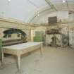
Shell House (NT37SW 168.4)
Three new trenches were excavated. The previous Trench 50 at the rear of the structure was considerably extended in order to fully expose the remains of the oven pit serving the intramural flue system that had been previously located. Trench 84 involved the excavation of a substantial area against the S wall of the structure in the hope of revealing details of the collapsed window within the rubble pile at that point; this produced a significant quantity of window glass but little other material, suggesting that the window had been wooden. Trench 85 was located at the lower W exterior wall foot of the Shell House to the N of the entrance. A further major sample of the midden of fallen decorative materials (such as exotic shells, minerals, glass and industrial waste) from the interior was recovered. New types of decorative materials include mirror fragments and pieces of carved mother of pearl (perhaps abalone shell) deriving from the decoration of an ornamental box or piece of furniture. A fragment was found of an aqua glass intaglio impression depicting a classical archer. This was most probably manufactured by the antiquarian James Tassie of Edinburgh in the later 18th century, and may have come from a collection of such objects at Newhailes House.
Cascade
Further investigation was made of the masonry remains exposed in 2001 just below and to the W of the Shell House. The S half of the feature was excavated, revealing it to have been a water cascade flowing down to the edge of a large, shaped pool (now infilled). Water emerged from a brick-vaulted culvert and fell down three semi-circular stone cascades (now largely robbed) before falling into the pool itself. Each tier was lead-lined and bounded by ashlar flanking walls that stepped out at each level. The latter were capped with 'rockwork', consisting of fragments of industrial (possibly smelting) waste to match the facade of the Shell House behind. Probable fittings for statuary were identified within the rear walls of the upper tier, and a large piece of sponge - artificial coral-form rockwork - was found loose within the feature, apparently part of its decoration. A small sondage revealed the continuation of the brick culvert vault to the E of its mouth, but its route beyond this remains uncertain.
The principal question that remains about the feature is its dating - is it coeval with the Shell House (thus 1770s), or does it relate to the laying out of the water gardens in the 1740s? It is possible that the rockwork is a secondary intervention. The feature had been infilled by the early 1790s. The cascade is paralleled by similar water garden features in association with grotto structures.
Tea House (NT37SW 168.5)
The project included the full exposure by excavation of the western wing wall flanking the Tea House, the recovery and record of fallen architectural stones revealed in that area, and the measured survey of the S elevation of the structure itself. The Tea House is a close copy of one of the pavilions flanking the Palladian bridge at Wilton (1736), by Roger Morris and the Earl of Pembroke, or its later copy at Stowe (1739). Historical research revealed that Roger Morris had most likely stayed in the vicinity of Newhailes, at neighbouring Brunstane House, in the entourage of the Duke of Argyll in 1744, and may well have had a direct influence in the design of the Newhailes Tea House (perhaps in collaboration with William Adam).
Paths
A series of small exploratory trenches, c 300mm square, were excavated to a depth that either confirmed no evidence of a path or showed the underlying make-up. This begins the mapping and phasing of the extensive network of paths within the wooded shelter belt in the area of the water gardens at Newhailes.
Lady's Walk
A concise recording exercise, limited archaeological evaluation and analytical assessment were undertaken of the stone gate piers at the SE entrance to Lady's Walk. Evidence for two phases of gates was discovered, the earlier, in association with the stone piers, coeval with the construction of Lady's Walk in the second quarter of the 18th century. In the entrance area if not beyond, the original ground surface was originally considerably lower than at present, with a lower threshold still in situ. The entrance appears originally to have contained wooden gates set to the rear of the columns.
The secondary reconditioning included the stabilisation of the stonework with braces and iron cramps and the installation of wrought iron gates with a threshold at a higher level. This seems to have occurred in the 19th century.
Ha-Ha
The relationship was examined between the ha-ha walls of the central area at their junction with those running out on either side. It was uncertain whether these walls were all coeval or laid out at different times. The ha-ha arrangement appears on Roy's map of c 1750 in more or less its present form, and it is clear from later maps that it has seen little subsequent modification. Four new trenches were excavated, confirming that the major elements of the ha-ha are coeval.
Archive to be deposited in the NMRS.
Sponsor: NTS.
D Connolly 2002
NT 326 725 Archaeological investigations were conducted on the water gardens dating from the 18th century, where pools, banks, cascades, paths and landscaping were explored. This work demonstrated that there are good levels of preservation in many areas and that several aspects of the gardens had silted up or been filled in, rather than destroyed. Key features located include a curling pond, cascade and pond. Investigations showed that large amounts of earth and stone boulders had been used to create a series of cascades and waterfalls, while renders had been used to create surface effects over bricks.
Three main evaluations were conducted elsewhere on the estate [see NT37SW 168.01 and NT37SW 168.07 also]:
Cabinet garden. The decorative scheme of two plinths was revealed leading down into the garden and demonstrated that the slope and garden were turfed.
A number of watching briefs were also conducted.
Archive to be deposited in East Lothian SMR and the NMRS.
Sponsor: NTS.
A Daly 2003
NT37SW 168.00 32687 72505 (Gate Piers to SW of house 32645 72461)
ARCHITECT:
James Smith (c.1700)
William Adam (c.1720's)
John Craig (1790)
Restored in 1907.
NT37SW 52 32532 72437 Newhailes, Dovecot
NT37SW 168.01 3263 7256 Newhailes, Ice House
NT37SW 168.02 32554 72417 Newhailes, Stables
NT37SW 168.03 32509 72397 Newhailes, Gardener's Cottage
NT37SW 168.04 3254 7270 Newhailes, Grotto
NT37SW 168.05 3253 7293 Newhailes, Tea House
NT37SW 168.06 32590 72680 Newhailes, Earl of Stair's Monument
NT37SW 168.07 3255 7253 Newhailes, Walled Gardens, Fruit Store and Terraced Walk
NT37SW 168.08 32666 72301 Newhailes, Newhailes Road, Main Gate
NT37SW 168.09 3273 7246 Newhailes, Formal Garden, Geophysical Survey
NT37SW 168.10 32649 72298 Newhailes, Lodge
NT37SW 168.11 32642 72492 Newhailes, Servants' Tunnel
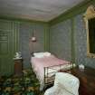
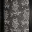
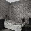
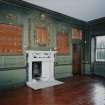
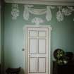
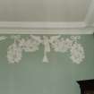
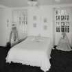
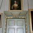
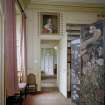
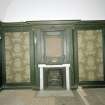
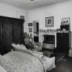
The Green bedroom is also known as the Grisaille bedroom
Information transcribed from Architecture Index, 1997:
REFERENCE:
National Library of Scotland: Newhailes Papers
MS 25673-8
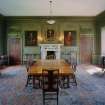
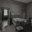
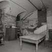
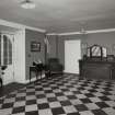
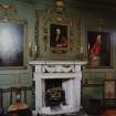
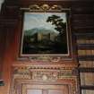
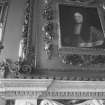
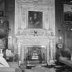
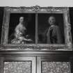
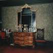
A series of albums compiled by Lady Newhailes and her sister the Countess of Cassilis with photographs of Newhailes including the Library, the present Chinese Room as the Billiard Room, 18th Century Great Drawing Room as Bt.'s Study and the Entrance Hall c.1905, views of the house and gardens, Watkin's feeding peacocks, herbaceous borders etc.
Including a newscutting of a Country Life type article illustrating China Room, Library and Dinner table set for a meal in Dining Room.
Also a letter notice for the house: 'Whoever the architect may have been he created a stately and . . . interior which has never been interfered with . . . even bedrooms panelled . . .'
REFERENCE:
Information from Helen Smailes, Scottish National Portrait Gallery
Henry and John Cheere
Dalrymple of Newhailes Papers (National Library of Scotland)
Correspondence of Sir James Dalrymple of Hailes, 2nd Bart, fos 153/4 - Letter from Henry Cheere, London
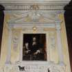
'Sir, I Recd the favour of yrs the Chimney with the Lyons Head and Skin is so far done that it cannot without a great deal of Expence be altered so I hope Sir you will be so good to excuse it tis very pretty veind that it is usd in it, so I hope Sir altogether it will make a very good chimney piece. I return many thanks Sir for the ?80 wch. I recd. I am going on as fast as I can possibly and will use my utmost endeavour to do 'em in the very best Manner I am greatly oblig'd to you Sir for your favours and am Sir your most obedt servt to Commd
Henry Cheere
Westminster Septr the 6th 1739'
fo 55 - Receipt from John Cheere
Nov:br the 19th 1740
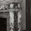
Rec:d of the Hon:ble Sir James Dalrymple by the hands of Mr George Honeyman the sum of forty five pounds and three shillings in full for the two Statues of Gladiators and two Sphynx and in full demands
[by] me John Cheere
Pounds 45: 3. 0.
REFERENCE:
Scottish Field, September 1949
Article by Sheila Forman
(not held by NMRS)
REFERENCE:
Country Life, September 1917
(not held by NMRS)
NMRS REFERENCE
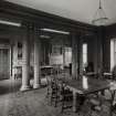
W Schomberg Scott Photograph Collection Acc no 1997/39, 3 prints: interior, the dining room and detail of staircase ironwork stables, oblique view.
Measured Survey (1950)
Photographic Survey (1 July 1959)
Photographic survey by the Scottish National Buildings Record in July 1959.
Photographic Survey (1959)
Photographic survey by the Scottish National Buildings Record/Ministry of Work in 1959.
Photographic Survey (18 April 1997)
Project (June 2000 - August 2001)
NT 3269 7250 A major programme of monitoring, evaluation and architectural recording was undertaken at the mansion house and within its surrounding policies during conservation works between June 2000 and August 2001. The principal findings include:
Mansion house (NMRS NT 37 SW 168). Numerous features were recorded during reservicing throughout the mansion interiors. Some refinement of the original layout of the James Smith villa of c 1690 was achieved, particularly at basement level. A 'secret passage' was revealed that provided private access to a suite of panelled rooms at first-floor level; this had subsequently been blocked off during the installation of a dumb waiter. General analysis of the Smith period masonry fabric confirmed that it did not incorporate earlier structural remains. A detailed record was made of part of the exterior before repair and reharling works; this recorded details of the original pressed-back harl and its scheme of regular ruling-out to imitate coursed ashlar, and a number of subsequent repairs that generally employed cementitious mixes. Evidence for the original principal entrance arrangement on the NE facade was recorded beneath the existing stair; the original stair had been narrower, and had had a vaulted chamber below that led to a basement entrance, subsequently blocked.
Mansion forecourt. An extensive series of trenches were excavated within the area of the mansion forecourt in order to determine its original details, layout and metalling materials, datable to the second quarter of the 18th century. The edges of the original central lawn area - defined by stone bollards - were identified, many original bollard pads remaining in situ. The make-up of the cambered metalling of the carriage circle was recorded, grading successively to an upper surface of fine pea gravel. The limits of the surrounding verge and details of the construction of the base of the mansion stair were also recorded.
Trenching beneath the gravelled surface revealed substantial remains of what were interpreted as earlier garden bedding trenches. These seem to have been laid in groups that suggest a formal parterre in this area, presumably of the Smith period in the late 17th century.
N side of mansion. Services trenching along the NE side of the mansion revealed details of the early 18th-century garden surfaces in that area. These overlay deposits that include two discrete midden dumpings that contained bottle glass and ceramics (including parts of a blue Nevers-type Lambeth tin-glaze vessel) of the late 17th/early 18th century, i.e. the Smith period. Evaluation and services trenches at the NE wall foot revealed the profile of a sunken area that permitted light to the basement windows.
Ha-ha. Two evaluation trenches examined the details of construction of the ha-ha that encloses the lawned area on the NE side of the mansion. Both trenches revealed a roughly faced rubblework front some 2m in height, with a sandstone cope. This had been constructed against a vertical cut into the natural. The cut extended in front to form a broad ditch that gently sloped down to the foot of the wall; 0.5m+ of redeposition was identified behind. One trench was located on the central NE-SW axis of the mansion in the hope that an earlier axial drive might also be identified, but without success.
Canal. Services trenching just beyond the N corner of the stables revealed parts of a brick-built retaining wall that defined the SW limit of a long ornamental canal, otherwise earth-banked and subsequently infilled. A NE return section of this wall had been constructed with an ornamental curving profile.
Water and drainage systems. General monitoring of services installation trenches exposed the well-preserved remains of an extensive network of stone-lined drains and water channels associated with the use of both the mansion house and stable block from the late 17th to the early 19th century.
Miscellaneous. Amongst a number of miscellaneous finds,
Project (1 June 2002 - 30 June 2002)
NT 325 727 The NTS volunteer Thistle Camp in June 2002 involved a number of problem-oriented evaluations and investigative exercises focusing on specific structures and areas within the Newhailes policies. A principal focus of the work was the Shell House and its immediate surroundings, where the original evaluation and recording completed in 2000/2001 was considerably extended. Substantial works were also undertaken at the Tea House, at the downstream end of the Newhailes water gardens - this included clearance, excavation, building recording and architectural analysis. A further small architectural recording and evaluation exercise was undertaken at the entrance gate piers at the SW end of Lady's Walk.
Another major aspect of the Thistle Camp programme was the investigation of the network of historic paths that formerly ran through the woodland shelter belt, particularly in the area of the water gardens. A series of evaluation trenches were located at key points along the ha-ha, to further investigate its phasing and details of its construction. Two topographic survey exercises were also carried out, one in the cabinet garden and the other in the area of the Shell House.
Project (2003)
NT 326 725 Archaeological investigations were conducted on the water gardens dating from the 18th century, where pools, banks, cascades, paths and landscaping were explored. This work demonstrated that there are good levels of preservation in many areas and that several aspects of the gardens had silted up or been filled in, rather than destroyed. Key features located include a curling pond, cascade and pond. Investigations showed that large amounts of earth and stone boulders had been used to create a series of cascades and waterfalls, while renders had been used to create surface effects over bricks.
Three main evaluations were conducted elsewhere on the estate [see NT37SW 168.01 and NT37SW 168.07 also]:
Cabinet garden. The decorative scheme of two plinths was revealed leading down into the garden and demonstrated that the slope and garden were turfed.
A number of watching briefs were also conducted.
Archive to be deposited in East Lothian SMR and the NMRS.
Geophysical Survey (1 September 2011 - 2 September 2011)
NT 32692 72533 A ground resistance survey was carried out 1–2 September 2011. A total of 14 grids measuring 20 x 20m were surveyed, over the promontory bounded by Newhailes House to the SW and the ha-ha to the NE, in an attempt to locate the line of the 1696 driveway to the house. A slight linear high resistance was noted running just right of centre in a NE direction. This was obscured in places by probable later garden features. At the NE of the site there were diffuse high resistance anomalies, possibly associated with two surviving stone statue bases. A further partial grid to the W of the Shell Grotto located the line of the culvert under the site of the former pond.
Archive: East Lothian Council SMR, NTS and RCAHMS (intended)
Funder: The National Trust for Scotland, Archaeology Scotland and EAFS
Edinburgh Archaeological Field Society (EAFS) 2011
Reference (January 2013)
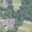
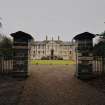
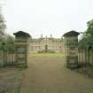
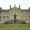
The main entrance to Newhailes house is through a pair of Burlington style ashlar gate-piers opening into the D-plan forecourt. The forecourt is enclosed by a wall, which also acts as a retainer for the earthwork terraces, and consists of a tarmac carriage circle around a lawn. The lawn is outlined by 29 stone bollards, and archaeological work in 2001 identified bollard pads from the original 18th century rectangular lawn. The same work uncovered the original gravel surface of the carriage circle and revealed remains of what have been interpreted as earlier garden bedding, dating to the late 17th century.
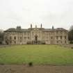
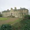
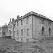
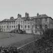
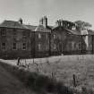
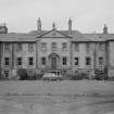
Originally built as the house of Whitehill in the late 17th century, the house’s current form dates to the first half of the 18th century when the east and west wings were added by Sir David Dalrymple.
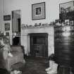
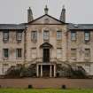
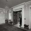
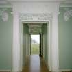
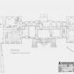
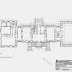
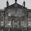
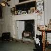
The house is a plain but impressive classical mansion house with basement, two principal floors and an attic within the roof spaces. The main elevations to north-east and south-west are of fifteen bays and are similar except for the difference in ground level; the principal floor level is raised half a storey above ground level to the N front, whilst on the S side it is raised a full storey above the ground level with a double flight of steps leading to the main entrance.
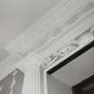
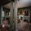
These principal elevations are composed of a seven bay centre block with slightly advanced three bay astylar pedimented centrepiece, a single recessed bay links this centre block to the three bay end pavilions, advanced a single bay. The house is built of random rubble with smooth harled finish lined in imitation ashlar work, with numerous patched repairs, with ashlar stone quoins and splayed door and window reveals. The hipped roofs are slated with leaded platforms over E and W wings and straight links. Paired chimney stacks rise above the N-S cross-walls of the central villa, a single stack rises over the E pavilion and a pair at right angles rise over the internal walls to the W pavilion.
S Elevation
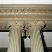
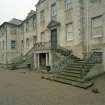
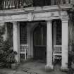
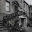
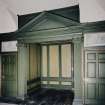
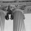
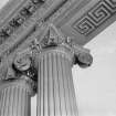
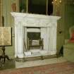
Faces the entrance court with symmetrical fifteen bay composition, the three central bays are slightly advanced with raised pediment, and two bays to either side. A painted stone distyle in antis Roman Doric portico is placed centrally and shelters the basement entrance. Its cornice has advanced keystone and the frieze is decorated with metope and triglyph, with guttae to architrave, the column shafts are plain;. A sweeping double stair with a wrought-iron balustrade rises to the principal entrance above which is framed with a pedimented doorcase with fluted tapering pilasters and lintol inscription 'LAVDO MANENTEM __ ' roughly translated as 'I praise her whilst she remains' with relief carving of a woman's and a man's heads with upturned shell in tympanum above.
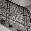
The double stairs cut across the face of the basement windows on either side of the centre bay and abut the stone platt of the portico. The wrought and cast-iron baluster with monogram and surrounding acanthus leafwork in central panel is surmounted with moulded timber handrail c.75 x 62mm. The panels below each flight of stairs are infilled with rock work, similar to character of rock work to entrance gates; each contains a relief head of a lion. The pediment over the three bay centrepiece is narrower than the advanced three bay centre piece. It has an oculus window with plain raised margin and glazed bulls-eye window set low down in the tympanum, probably to avoid the flue which rises from the fireplace to the apex of the pediment where it terminates in a 19th century chimney can.
To either side of the central seven bay villa are slightly recessed single bay straight links to the slightly advanced three bay east and west end wings. These contain doorways with lay-light over and above matching fenestration to ground and first floors.
The windows to the Sand W elevations of the E wing are all blinded, with painted astragals which match the other windows, except at Ground Floor level where the blinded windows have been overpainted to change the 2/2 design to 4/4. The raised margins to the blind windows at basement level are formed in render without deep reveals.
The facade is of harled masonry lined off to imitate ashlar coursing with rusticated quoins to the central villa, moulded,stone cornice and plinth. The window openings have plain sandstone margins, monolithic cills and lintols with chamfered reveals. The ground floor windows have two over two double hung sash and case windows with recessed cases concealed behind stone rybats. The first floor windows are six over six double hung sash and case windows.
The W wing completes symmetry of E wing, its three basement windows to the Kitchen are of six over six style sash and case are fitted with arrow headed security bars.
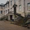
N Elevation
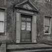
The N elevation, similar to the S elevation but with single straight flight of seven steps rising from the ground level to the entrance platt. The matching pedimented entrance doorcase with tapering pilasters with lintel inscription "_ SAPIENTER V TI" (to use wisely) and a profile relief of a man's head facing W is set in tympanum above.
The pediment over the three bay centrepiece matches the south, with oculus window with plain raised margin and glazed bulls-eye window set low down in the tympanum, and chimney stack to pediment.
The windows to the east wing are all blinded and painted to match the differing window pattern on each floor. The two bulls-eye ventilation openings at basement level have been built up and rendered over.
The window openings have matching sandstone margins, monolithic cills and lintols with chamfered reveals. The ground floor windows to the central villa and straight linking bays have two over two double hung sash and case windows with recessed cases concealed behind stone rybats. The ground floor windows to the west wing are six over six double hung sash and case windows and six over six fixed casement window to the West Stair. The first floor windows have six over six double hung sash and case windows with recessed cases concealed behind stone rybats and two horizontal bars fixed across the lower sashes. The basement windows are of various heights and types all with horizontal security bars.
The facade is of much patched harled masonry with rusticated quoins to the central villa, moulded stone cornice and plinth and plain raised stone margins to corners of pavilion wings.
E Elevation
The end wall of the east wing contains five tall round arch windows each with raised stone margins surmounted by impost capitals and with shell keystones to each round arch. The centre window extends to ground level as a door and a carved stone wall mounted sundial is located above. Blank rectangular ashlar tablets are located above each window. Below each window, a small bull's-eye ventilation openings are located below the moulded stone string course providing ventilation to provide ventilation and light to the basement Cellars. A small basement area extends c.O.75m below adjacent ground level and is bridged by a stone platt to central door.
The wall is harled with plain raised margins at each corner.
W Elevation
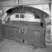
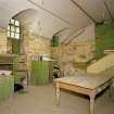
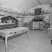
The W elevation is of two bay composition above the basement area which provides access
from the Services tunnel to the Old Kitchen, the Scullery and the basement floor of the house.
Two round arched windows to principal floor level with moulded stone margins, impost capitals and advanced keystone. The window opening to the N is fitted with a cast-iron sash and case window, with radial and Y traceried pattern within arched head. To the S, the matching window opening is blank with painted fenestration to match the adjacent window. Above, two square windows to first floor with broad pilaster strips to outer angles. The windows have three over three double hung sash and case windows with recessed cases concealed behind stone rybats.
The wall is harled with cement patching and panelled corners at each end. The moulded stone cornice and string course are continuous with the adjoining elevations.
The basement wall below the string course, previously internal, contains door to Old Kitchen with plain raised margins and flat arched head is slightly off-set from S bay. To N, a door opening with lay-light over and matching basement doors to linking bays between main villa and pavilions on S elevation, provides access to Kitchen Corridor and window opening to its N, also with plain raised stone margins. The wall is finished with lime plaster and evidence of beam holes exist immediately below moulded stone string course.
The roofs are slated with flat leaded sections to centre of straight links and end wings.
To the east of the house, directly overlooked by the library is the Cabinet Garden. It consists of a lawn, surrounded by trees forming an outdoor room, and was designed as an extension of the library.
To the north (rear) of the house is an area of open lawn, running for 150m in length to the parkland beyond. The lawn once featured 4 statues, a pair of sphinxes and a pair of gladiators, installed in the 1740s and stolen in 1949, all that now remains are the plinths.
The lawn is separated from the parkland by a ha-ha, archaeological excavation of it has shown that the wall of the ha-ha was in fact 2m in height, constructed of roughly faced rubble work with a sandstone cope, and demonstrating that the ditch had at some point been filled in. This filling in may have been the reason for the construction of the iron fence on top of the ha-ha, in order to maintain an effective barrier between the lawn and the parkland.
Information from NTS

