
Inveresk, Inveresk Gate


Ditch (Roman), Track (Roman), Well(S) (Roman)
Site Name Inveresk, Inveresk Gate
Classification Ditch (Roman), Track (Roman), Well(S) (Roman)
Canmore ID 183602
Site Number NT37SW 1235.01
NGR NT 344 719
NGR Description NT c. 344 719
Datum OSGB36 - NGR
Permalink http://canmore.org.uk/site/183602

- Council East Lothian
- Parish Inveresk (East Lothian)
- Former Region Lothian
- Former District East Lothian
- Former County Midlothian
NT37SW 1235.01 (formerly NT37SW 8.03) c.344 719
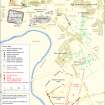
NT 344 719 An evaluation and watching brief were undertaken on a house plot and its associated driveway which lie within the Scheduled area of the Roman military and civil settlement at Inveresk.
Plot 16 lies along the W boundary of the development. The evaluation was undertaken on the plot while an archaeological watching brief monitored the ground reduction of the driveway and its graded slope. As a consequence of the findings from the evaluation, an excavation of the house 'footprint' was undertaken immediately.
The excavation was carried out between October and November 1999 and covered an area of approximately 300m2. The terminal of a major Roman military ditch on an approximate E-W alignment was discovered along with the metalled or cobbled surfaces of former tracks or roadways, pit features and a possible sleeper trench. A smaller ditch feature, provisionally interpreted as a drain and orientated SSW-NNE, lay to the N of the military ditch.
The watching brief on the driveway revealed adjacent stone-lined and timber-lined wells of Roman date.
Sponsor: Cala Homes (Scotland) Ltd.
J Gooder 2000.
Archaeological Evaluation (October 1999 - November 1999)
NT 344 719 An evaluation and watching brief were undertaken on a house plot and its associated driveway which lie within the Scheduled area of the Roman military and civil settlement at Inveresk.
Plot 16 lies along the W boundary of the development. The evaluation was undertaken on the plot while an archaeological watching brief monitored the ground reduction of the driveway and its graded slope. As a consequence of the findings from the evaluation, an excavation of the house 'footprint' was undertaken immediately.
The excavation was carried out between October and November 1999 and covered an area of approximately 300m2. The terminal of a major Roman military ditch on an approximate E-W alignment was discovered along with the metalled or cobbled surfaces of former tracks or roadways, pit features and a possible sleeper trench. A smaller ditch feature, provisionally interpreted as a drain and orientated SSW-NNE, lay to the N of the military ditch.
The watching brief on the driveway revealed adjacent stone-lined and timber-lined wells of Roman date.
Sponsor: Cala Homes (Scotland) Ltd.
J Gooder 2000.

