
Inveresk


Field System (Period Unknown)
Site Name Inveresk
Classification Field System (Period Unknown)
Alternative Name(s) Pinkiehill
Canmore ID 53694
Site Number NT37SE 50
NGR NT 35150 71430
NGR Description NT 351 714 to NT 351 715
Datum OSGB36 - NGR
Permalink http://canmore.org.uk/site/53694


- Council East Lothian
- Parish Inveresk (East Lothian)
- Former Region Lothian
- Former District East Lothian
- Former County Midlothian
NT37SE 50 351 714 to 351 715
See also NT37SE 34 and NT37SE 69.
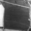
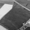
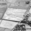
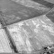
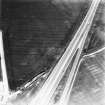
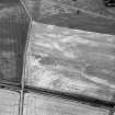
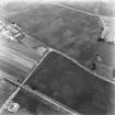
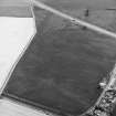
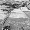
NT 351 714 to NT 351 715. Field-system, enclosures, and cropmarks, Sweethope: visible on aerial photographs. Enclosure at NT 352 713.
(Undated) information in NMRS.
NT 3210 7303 to NT 3579 7184 Archaeological works along the line of a sewer pipeline revealed significant archaeological remains. The pipeline ran for 5km between Wallyford Waste Water Treatment Works and the eastern interceptor sewer near Portobello.
The investigation of an extensive area of cropmarks at Inveresk, specifically those to the S of the Edinburgh to Dunbar railway line, exposed three main groups of features: linear features that formed enclosures (NMRS NT37SE 50) and field systems lying on a pronounced gravel ridge; two Roman temporary marching camps (NMRS NT37SW 33 and NT37SW 186 ); and features whose function and origin is not known (NMRS NT37SW 68 and NT37SW 182 ).
The main group of cropmark features (NMRS NT37SE 50), is assumed to represent the southern extent of a field system associated with Inveresk Roman fort to the N and comprises four feature groups: a series of ditches bounding large areas to the NE; a series of smaller enclosures; a small rectilinear enclosure to the far SW; and a linear trackway running roughly NE-SW through the series of smaller enclosures
Sponsor: M J Gleeson Group plc.
Murray Cook 2001
Archaeological Evaluation (2001)
NT 3210 7303 to NT 3579 7184 Archaeological works along the line of a sewer pipeline revealed significant archaeological remains. The pipeline ran for 5km between Wallyford Waste Water Treatment Works and the eastern interceptor sewer near Portobello.
The investigation of an extensive area of cropmarks at Inveresk, specifically those to the S of the Edinburgh to Dunbar railway line, exposed three main groups of features: linear features that formed enclosures (NMRS NT 37 SE 50) and field systems lying on a pronounced gravel ridge; two Roman temporary marching camps (NMRS NT 37 SW 33 and 186); and features whose function and origin is not known (NMRS NT 37 SW 68 and 182).
The main group of cropmark features (NMRS NT 37 SE 50), is assumed to represent the southern extent of a field system associated with Inveresk Roman fort to the N and comprises four feature groups: a series of ditches bounding large areas to the NE; a series of smaller enclosures; a small rectilinear enclosure to the far SW; and a linear trackway running roughly NE-SW through the series of smaller enclosures
Sponsor: M J Gleeson Group plc.
Murray Cook 2001
Aerial Photographic Interpretation
NT 351 714 to NT 351 715. Field-system, enclosures, and cropmarks, Sweethope: visible on aerial photographs. Enclosure at NT 352 713.
(Undated) information in NMRS.

