
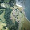
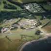
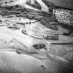
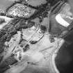
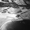
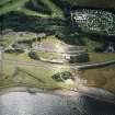
Prestongrange Colliery


Building (Period Unassigned)
Site Name Prestongrange Colliery
Classification Building (Period Unassigned)
Canmore ID 113113
Site Number NT37SE 78.03
NGR NT 371 738
NGR Description NT c. 371 738
Datum OSGB36 - NGR
Permalink http://canmore.org.uk/site/113113


- Council East Lothian
- Parish Prestonpans
- Former Region Lothian
- Former District East Lothian
- Former County East Lothian
NT37SE 78.03 371 738
Site recorded during a rapid coastal survey undertaken by GUARD of the S shore of the Firth of Forth from Dunbar to Stirling and along the N shore of the Forth to the Fife border. A gazetteer of all sites including listed buildings, designed landscapes, scheduled and unscheduled monuments was produced. Full details of the survey can be consulted in the report held by the NMRS.
Sponsor: Historic Scotland
GUARD 1996
Reference (1996)
Site recorded during a rapid coastal survey undertaken by GUARD of the S shore of the Firth of Forth from Dunbar to Stirling and along the N shore of the Forth to the Fife border. A gazetteer of all sites including listed buildings, designed landscapes, scheduled and unscheduled monuments was produced. Full details of the survey can be consulted in the report held by the NMRS.
Sponsor: Historic Scotland
GUARD 1996

