
Edinburgh, Holyrood Park, Queen's Drive, St Margaret's Well


Graffiti (21st Century), Well House (15th Century)
Site Name Edinburgh, Holyrood Park, Queen's Drive, St Margaret's Well
Classification Graffiti (21st Century), Well House (15th Century)
Alternative Name(s) Queen's Park; St Margaret's Well-house
Canmore ID 52167
Site Number NT27SE 15
NGR NT 27133 73712
Datum OSGB36 - NGR
Permalink http://canmore.org.uk/site/52167


- Council Edinburgh, City Of
- Parish Edinburgh (Edinburgh, City Of)
- Former Region Lothian
- Former District City Of Edinburgh
- Former County Midlothian
NT27SE 15 27133 73712 and 2808 7428
(NT 2808 7428) St Margaret's Well (NR)
OS 1:1056 plan, (1852)
(NT 2713 7371) St Margaret's Well (NAT)
OS 1:2500 map (1968).
Queen's Park was the site of a temporary smallpox hospital in 1894.
(Undated) information in NMRS.
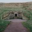
In 1852, St Margaret's Well, a holy well (Walker 1883) is described as a spring well, enclosed by an ancient vault over which part of the railway workshops had been built. In 1860, this well-house was rebuilt in its present position. It is a miniature Gothic cell of the 15th century, evidently based on, and therefore later than, St Triduana's Well at Restalrig (NT27SE 103.1).
Name Book 1852; D Laing 1862; J R Walker 1883; RCAHMS 1951.
This well is as described above.
Visited by OS (S F S) 2 December 1975.
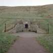
St Margaret's well-house is set into the natural hillslope immediately below the modern track that provides vehicular access to Hunter's Bog. It is is fronted by a curvilinear stone facade surmounted by iron railings and is plotted at 1:5,550 on an archaeological map of Holyrood Park (RCAHMS 1999).
Visited by RCAHMS (ARG), 26 October 1999
NMRS, MS/726/96 (52, no. 35); RCAHMS 1999.
St Margaret's Well [NAT] (at NT 27133 73712)
OS (GIS) MasterMap, November 2009.
Publication Account (1951)
193. St. Margaret's Well, King's Park.
In 1855 the attention of the Society of Antiquaries of Scotland was drawn to the deplorable condition of St. Margaret's Well, which stood at Restalrig on a site occupied by part of St. Margaret's railway depot (1), and a committee was appointed to investigate the matter. Meanwhile Dr. David Laing, then one of the Secretaries, warmly advocated the adoption of a proposal made by Hugh Miller that the superstructure of the well should be rebuilt over a similar spring which existed in the Queen’s Park, near St. Anthony's Chapel (2). In its report, issued in the following year, the Committee recommended that the structure should be rebuilt near the E. entrance to the demesne, where St. Anthony's (now St. Margaret's) Loch was shortly to be formed (3). The report was unanimously adopted, and the Society entered upon negotiations with the railway directors and other interested parties. In February 1860 the Secretary was able to report that the reconstruction had been effected by H.M. Commissioners of Works, the Society having guaranteed part of the expense. The site advocated, however, had proved unsuitable, and another had accordingly been chosen on the N. slope of Salisbury Crags, close to a spring formerly called St. David's Well (4).
The well-house thus rebuilt is a miniature Gothic cell of the 15th century, evidently based on and herefore rather later than its quondam neighbour, St. Triduana's Well at Restalrig Church (No. 220 [NT27SE 103]). On plan it is hexagonal with sides 4 ft. 4 in. long and a diameter of 7 ft. 6 in. The height, measured from the floor to the soffit of the ridge-ribs, is.6 ft. 2½ in. Round the walls there returns a diminutive bench 6½ in. wide. The entrance, which faces N., is 2 ft. 8 in. wide, and has splayed jambs and a semicircular head. There are no other openings. The roof is a ribbed vault constructed like that of St. Triduana's Well with foliaceous bosses at the rib-junctions. The ribs spring from wall-corbels in the angles, and rise to a central circular pier which, bears on its N. face a grotesque human head much restored in plaster and provided with a modern spout supported on an iron bracket. Masons' marks are found on the ribs and central pier, while an arrow-head is wrought on the outer face of each, corbel. The structure is in use and is in good repair.
RCAHMS 1951, visited c.1941
(1) P.S.A.S., ii (1854-7), p. 102. (2) Ibid., pp. 143-7 (3) Ibid., pp. 218-9. (4) Ibid., iii (1857 -60), pp. 365-7.
Project (1997)
The Public Monuments and Sculpture Association (http://www.pmsa.org.uk/) set up a National Recording Project in 1997 with the aim of making a survey of public monuments and sculpture in Britain ranging from medieval monuments to the most contemporary works. Information from the Edinburgh project was added to the RCAHMS database in October 2010 and again in 2012.
The PMSA (Public Monuments and Sculpture Association) Edinburgh Sculpture Project has been supported by Eastern Photocolour, Edinburgh College of Art, the Edinburgh World Heritage Trust, Historic Scotland, the Hope Scott Trust, The Old Edinburgh Club, the Pilgrim Trust, the RCAHMS, and the Scottish Archive Network.
Field Visit (18 July 2002)
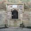
Bell shaped cobbled area framed by curved rising sandstone(?) wall with framed arch in centre (now boarded up). Projected counter in front of arch contains inset round drinking bowl made of square pinkish granite. Metal workings below at front now missing leaving gap at front. Wall surmounted by plain railings.
Inspected By : A. Taubman
Inscriptions : On plaque (raised letters, upper and lower case):
This unique well house dates from the / late 15th century. It originally stood at / Restalrig, close to the church, and its / design is a miniature copy of St. Triduana's / Aisle there. In 1860 it was removed from / its first site, which was then encroached / upon by a railway depot, and was / reconstructed in its present position near / a natural spring.
Signatures : None Visible
Design period : late 15th century
Year of unveiling : 1860
Information from Public Monuments and Sculpture Association (PMSA Work Ref : EDIN0989)
Field Visit (19 November 2017)
Graffiti in the form of letters written in black marker pen are visible on the right-hand side of the sandstone surround to the entrance to the well.
Visited by HES Survey and Recording (JRS) 19 November 2017.

