
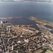
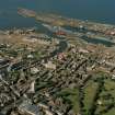
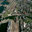
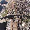
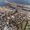
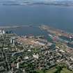
Edinburgh, Leith Docks, Victoria Swing Bridge


Swing Bridge (19th Century)
Site Name Edinburgh, Leith Docks, Victoria Swing Bridge
Classification Swing Bridge (19th Century)
Alternative Name(s) Ocean Drive; Water Of Leith; Inner Harbour; Albert Dock; Victoria Dock
Canmore ID 51986
Site Number NT27NE 57.42
NGR NT 27085 76817
Datum OSGB36 - NGR
Permalink http://canmore.org.uk/site/51986


- Council Edinburgh, City Of
- Parish Edinburgh (Edinburgh, City Of)
- Former Region Lothian
- Former District City Of Edinburgh
- Former County Midlothian
Two ‘slices’ were taken through a large timber post that was excavated from the quayside area of the docks at the Victoria Swing bridge, Leith. The maximum trunk radius measured was 210 mm, with the timber having been shaped to a roughly square cross section. A preliminary inspection indicated that approximately 80 – 100 growth rings were present at the thickest parts of the timber, but this is probably an underestimate. The post had been impregnated with creosote.
Analysis of the wood indicated that it was coniferous, due to the lack of vessels and the presence of tracheids with large bordered pits in single rows. Further examination showed that on the radial longitudinal section, the cross field cells show fenestriform pits and the cells of the ray tracheids have dentate cell walls. These features indicate that the wood is Pinus sylvestris type (Scots pine type), which includes both Pinus sylvestris (Scots pine) and Pinus mugo (mountain pine).
Information from Dr Susan Ramsey for GUARD Archaeology 2013.
NT27NE 57.42 27085 76817
Victoria Bridge
(swing) [NAT]
OS 1:1250 map, 1970.
Formerly entered as NT27NE 61.
For successor fixed structure (Victoria Bridge, at NT 768549 27063), see NT27NE 57.59.
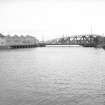
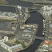
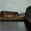
The hydraulically-operated Victoria Swing Bridge across the Inner Harbour, linking the Albert Dock (NT27NE 57.38) to the Victoria Dock (NT27NE 57.06), also by Rendel and Robertson, 1871-4, was replaced later with a bowstring swing bridge.
J Gifford, C McWilliam and D Walker 1984.
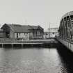
This swing bridge was once driven by the adjacent hydraulic power station (NT27NE 57.34).
Visited by RCAHMS (MKO), 9 June 1993
This site has only been partially upgraded for SCRAN. For further information, please consult the Architecture Catalogues for City of Edinburgh District..
March 1998
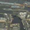
This bridge formerly carried a private road and dock railway across the mouth of the Water of Leith on the S side of the Leith dock system (NT27NE 57.00). Its location probably represents the former shoreline.
Following the extensive remodelling of the S side of the dock estate, it now carries a road (Ocean Drive) which passes in front of the Scottish Executive (formerly Scottish Office) building (Victoria Quay: ). It is separated by fencing from the remaining operational portion of the dock system.
Hydraulic power has presumably been supplied to this bridge from the hydraulic power station (NT27NE 57.34) situated adjacent to the NE. The swinging-recess is on the E side.
Information from RCAHMS (RJCM), 13 June 2006.
Large, single span, bowed truss hydraulic swing bridge of riveted wrought-iron, timber and steel construction. Asymmetrical arch profile defines the cantilever span. 120 ft clear span and overall length of 212 ft. The roadway width is 24 ft. Timber deck and pedestrian walkways to either side. Metal railings along the outer edge of the pedestrian walkways on each side of the bridge. Timber resting platform along quayside to north west. Flight of concrete steps running down the south east side of the turning platform, from the bridge deck level to the bottom of the platform. (Historic Environment Scotland List Entry)
Construction (1871 - 1874)
Victoria Bridge linked east and west side of Leith Harbour, specifically Victoria Dock with Edinburgh Dock (1874-1881) and Albert Dock (1862-69). Rendel worked on both these docks and ancillary structures such as the swing bridge.
Project (2007)
This project was undertaken to input site information listed in 'Civil engineering heritage: Scotland - Lowlands and Borders' by R Paxton and J Shipway, 2007.
Publication Account (2007)
The construction of the Albert and Edinburgh Docks made it necessary to have an efficient means of communication between the east and west side of the harbour for road and railway use which led to the construction of the Victoria Swing Bridge from 1871 to 1874. Its girders, with an overall length of 212 ft and clear span of 120 ft, are made of wrought-iron and the clear roadway width is 24 ft. The gross weight is 620 tons, including 60 tons of timber and 240 tons of kentledge counterweight which was, but is no longer, lifted and easily turned by means of hydraulic rams. Its clear span is said to have been the largest of any swing bridge in the United Kingdom until the opening of Kincardine Bridge in 1937. The engineers were Rendel and Robertson (resident engineer J. H. Bostock). The contractors for the foundations were McDonald & Grant and, for the bridge, Skerne Iron Works (late Pease, Hutchison & Co., Darlington who made the ironwork). The cost was about £30 000.
R Paxton and J Shipway 2007
Reproduced from 'Civil Engineering heritage: Scotland - Lowlands and Borders' with kind permission of Thomas Telford Publishers.
Watching Brief (2013)
At the mouth of the Water of Leith in the Inner harbour, linking the Albert Dock to the Victoria Dock is a late nineteenth century hydraulically-operated swing bridge that formerly carried a private road and dock railway. The bridge would open by turning or swinging round to the east
with the superstructure of the bridge fitting into a purpose built recess on the quayside. The engine house for the bridge is located slightly to the south-east next to Ocean drive. The bridge no longer operates and is a Scheduled Ancient Monument (SAM 3709) and is a category B Listed
Building (HB Number 27644). Although the bridge itself was not affected by the tram works part of the recess for the bridge when it was open on the south side was going to be built over by work to widen the bridge on Ocean Drive. Similar work on the north side of the river had a more limited impact. The ground-works were monitored in accordance with the Written Scheme of Investigation attached to the Scheduled Monument Consent granted by the Scottish Government.
A foundation trench was machine-excavated on the south side of Victoria Swing Bridge, prior to the placement of a structural pile. A cobbled surface and part of a brick wall was uncovered at NGR: NT 7032 6861. The cobbles had been disturbed by the insertion of modern power cables. These were removed to uncover the solid stone foundation of the quayside below which
was then used as a base for the new foundations. The original quayside was protected with geotextile before the new concrete was laid on top.
A watching brief was undertaken during trenching for foundations on the north side of the bridge at the west abutment. Below the existing concrete pavement was a deep deposit of loose brick rubble. As this rubble was being removed a wooden structural pile or pier stanchion was
uncovered. A sample of wood from the pile was taken and has been examined (see belowaccount by Dr Susan Ramsey).
Water was encountered at a depth of 2.1 m below pavement level.
Information from Christine Rennie and Bob Will (Guard Archaeology) 20 February 2013

