
Edinburgh, Leith, Dock Street, Johnston Street, Citadel Arch


Artillery Fortification (17th Century)
Site Name Edinburgh, Leith, Dock Street, Johnston Street, Citadel Arch
Classification Artillery Fortification (17th Century)
Alternative Name(s) Citadel Of Leith; Leith Citadel; Cromwellian Fort
Canmore ID 51917
Site Number NT27NE 10
NGR NT 26782 76615
Datum OSGB36 - NGR
Permalink http://canmore.org.uk/site/51917


- Council Edinburgh, City Of
- Parish Edinburgh (Edinburgh, City Of)
- Former Region Lothian
- Former District City Of Edinburgh
- Former County Midlothian
NT27NE 10 26782 76615
(NT 2678 7661) Citadel Port (NR)
Citadel (NR) (remains of)
OS 6" map, Edinburghshire, 1st ed., (1853).
For discovery or discoveries of bronze axes (possibly a hoard) near the citadel, see NT27NE 16.
For indeterminate 'Roman' remains (found 1825, 'in the neighbourhood of the Citadel'), see NT27NE 23.
For 2004 discovery of part of the course of the Leith Citadel ditch and revetment wall (at NT 267 765), see NT27NE 1555.
After the battle of Dunbar in 1650, Cromwell took possession of Leith and introduced a number of English settlers. For their protection, General Monk erected a citadel at the NW corner of North Leith, partly on the parish burial ground. (see NT27NE 9).
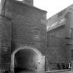
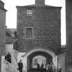
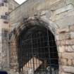
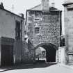
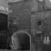
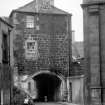
According to Maitland (1753) it was pentagonal in shape with a bastion at each corner and one gateway, facing E. Arnot (1788) writing in 1779, notes that apart from "a strong gate with portcullices" most of the Citadel had already been demolished. The substructure of this gate still survives, giving access from Dock Street to Johnstone Street. It consists of a vaulted pend, with an arched gateway at either end. The gateway to the NE has provision for a double door, no doubt the "portcullices" mentioned by Arnot. The superstructure has been rebuilt as a house of two storeys.
W Maitland 1753; H Arnot 1788; RCAHMS 1951.
No change from previous information.
Visited by OS (B S) 27 November 1975.
The parapet is a conjectured reconstruction by Edinburgh City Architect's Department, 1964.
J Gifford, C McWilliam and D Walker 1984.
NT 2674 7654 The projected route of the Leith Citadel ditch and revetment wall (NT27NE 10) was found during an evaluation between November 2004 and January 2005. Evidence of later stone robbing from the revetment wall was also recorded. In addition, buried garden soils possibly dating to the 17th century were seen to exist in the NE part of the site. Earlier coastal deposits also survived on site. No evidence was encountered of structures within the Citadel.
Archive to be deposited in NMRS.
Sponsor: Hart Estates Ltd.
E Hindmarch 2005.
NT27NE 10 26782 76615
Also known as Cromwell Barracks, built about 1656 by General Monk.
Demolished c.1948 to make way for industrial development.
Historical file.
"The Citadel Leith"
- 1 Drawing by Rollo.
- 1 News cutting.
In the National Library of Scotland, Vol.II., No 37, of Water Colour Sketches by Thomas Brown, Advocate, is a view in this Street. It seems to show the Citadel Port. Reference "Adv. MSS. 34.8.1-3"
See under "Water colour Sketches, series of, by Thomas Brown, Advocate".
Edinburgh, Leith, Citadel Feuing.
James Gillespie Graham.
Leith, lands at the Citadel. Feuing plan, 1807.
(Edinburgh Evening Courant, Feb 14, 1807).
Sources: Dean of Guild 2.6.1814
Pet. John Martin, Merchant in Queensferry.
Corner tenement fronting the Citadel of Leith, near to the West end of therof - - precise location unknown at time of upgrade, 8.2.2000
Minor alterations - door.
Publication Account (1951)
230. The Citadel, Johnstone Street.
After the battle of Dunbar, fought in 1650, Cromwell took possession of Leith and introduced a number of English settlers. As might be expected, differences soon arose between the incomers and the natives. The English minority, having failed to get their case considered by a Commission set up for the purpose, which consisted of two Scottish judges together with General Monk representing Commonwealth interests, laid a petition before the Council of State setting forth the grievances under which they laboured. When the Town Council of Edinburgh heard of this latter step they were not unnaturally alarmed; it was rumoured that the English were about to fortify Leith and they feared that Edinburgh might not only be deprived of its rights and superiority but might even lose possession of the port that was essential to its trade. A Commission was thereupon appointed by the magistrates to treat with General Monk. At a meeting which took place at Dalkeith Monk informed the Commissioners that he had been instructed either to fortify the whole town of Leith or to erect a citadel therein, the choice of site in N. or S. Leith being left to him. Pointing out that the major proposal would certainly prejudice the rights and privileges of Edinburgh, he drove a hard bargain, demanding, as his price for proceeding with the minor scheme, that Edinburgh should contribute £5,000 sterling towards the cost of the citadel. Faced with these alternatives the Town Council chose the lesser evil, stipulating, however, that their rights and privileges in Leith were to be confirmed. Monk agreed to this condition; the matters in dispute were settled in favour of Edinburgh, and the money was handed over in three instalments.
The Citadel was constructed at the N.W. corner of N. Leith, partly on the parish burial-ground. According to Maitland (1) it was pentagonal in shape with a bastion at each corner and one gateway, which faced E. When the Restoration was an accomplished fact it was decided to demolish the Citadel; but Lauderdale, scenting a handsome profit, obtained a grant of the place from the Crown, together with another grant of a free burgh of regality and barony, and offered the whole to Edinburgh at an exorbitant price. Fearing to incur the displeasure of the most powerful minister in the kingdoms if they refused, the Town Council of Edinburgh paid £6,000 in 1663 for the Citadel which had been erected at their own expense. Commenting on the whole transaction less than a century later Maitland (2) says "This Bugbear, which cost the Edinburghers no less a Sum than Eleven thousand Pounds Sterling, is, in a short Time, likely to become a Prey to the Sea; for, by its violent Attacks, it has already strip'd it of its strong stonern Wall on that Side, and destroyed its two Northern Bastions." Arnot (3) reports in 1779 that apart from "a strong gate with portcullices" most of the Citadel had already been demolished. The substructure of this gate still survives and gives access from Dock Street to Johnstone Street. It consists of a vaulted pend, at either end of which is an arched gateway surmounted by a hood-mould. The gateway to the N.E. has provision for a double door, no doubt the "portcullices" mentioned by Arnot. The superstructure has been rebuilt as a house of two storeys.
RCAHMS 1951, visited c.1941
(1) History, p. 499. (2) Loc. cit. (3) History, p. 572 .
Trial Trench (January 2002 - August 2002)
NT 267 765 Two phases of archaeological trial trenching were carried out on the site of the Brodies Tea and Coffee building, 1 Dock Street, Leith. The site was believed to lie within the area occupied by a citadel (NT27NE 10) built in 1656 by General Monck and mostly demolished by 1779.
The first phase beneath the car park to the rear of the building identified post-medieval building foundations. The orientation of these was consistent with interior citadel structures shown on Naish's plan of 1709.
The second phase of work was carried out following the demolition of the building. Modern clearance, probably associated with the construction of Brodies, had removed all archaeologically significant remains above the level of compact clay subsoil. The southern part of the site contained the defensive ditch of the citadel, which extended to a depth of 3.8m below the level of subsoil and was lined on the inside with a thick ashlar-faced sandstone wall bonded with lime mortar. The ditch did not return to the N in the excavated area, and it is suggested that this must occur beneath modern Dock Street, as suggested by Wood's plan made in 1777. The fill of the ditch was a relatively clean clay, probably its own upcast, used for a time as rampart material. The remains have been preserved beneath the new development.
Archive to be deposited in the NMRS.
Sponsor: Gregor Shore plc.
G Brown and S Stronach (Headland Archaeology) 2002.
Watching Brief (5 May 2008 - 9 May 2008)
The watching brief was undertaken from the 5th to 9th May 2008, and consisted of a large 'U' shaped area being excavated at the eastern end of what was the nave of the church. The watching brief revealed six substantial walls, five of which were of dressed sandstone set into post medieval clay deposits. Evidence of a basement or vault in the northeastern corner of the building was also recorded during the works. These features may be associated with the churches of, St Nicholas, St Ninian's or even the Cromwellian Citadel, all of which existed on this site prior to its dedication as The Mariner's Church.
Information from AOC Archaeology Group
Excavation (10 April 2012 - 4 May 2012)
NT 2675 7606 A 10% evaluation was undertaken April – May 2012 on the site of a proposed housing development at 72–92 Great Junction Street. The works identified evidence for the medieval and post-medieval occupation of Leith. The main feature identified consisted of a NW–SE aligned ditch, which represents the remaining fragment of the 16th-century defences of Leith. The ditch was identified across the entire development. A series of features post-dating the ditch were also identified and comprise large rubbish pits. Subsequent development on the site consisted of the infilling of the ditches and the construction of a well in the 18th century. Finds included 16th- to 18th-century ceramics.
Archive: RCAHMS
Funder: Port of Leith Housing Association
Information from Martin Cook (AOC Archaeology Group) May 2012. OASIS ID: aocarcha1-119549 and
Martin Cook, AOC Archaeology Group
2012

