
Woodhouselee Hill


Palisaded Enclosure (Prehistoric)
Site Name Woodhouselee Hill
Classification Palisaded Enclosure (Prehistoric)
Canmore ID 51775
Site Number NT26NW 31
NGR NT 23339 65029
Datum OSGB36 - NGR
Permalink http://canmore.org.uk/site/51775


- Council Midlothian
- Parish Glencorse
- Former Region Lothian
- Former District Midlothian
- Former County Midlothian
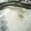
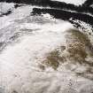
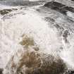
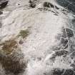
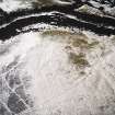
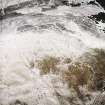
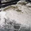
This palisaded enclosure is situated on the summit of Woodhouselee Hill, a rounded spur on the E flank of Castlelaw Hill. Roughly oval on plan, the interior of the enclosure measures about 73m from N to S by a maximum of 52m transversely at its broader N end. The perimeter comprises two twin palisade trenches, each pair separated by a low medial bank up to 1.5m in thickness. These lie about 6m apart, and both pairs terminate in hairpin terminals at an entrance on the SE. In both palisades the inner trench is the better defined, but nowhere is it more than a shallow groove about 0.4m in breadth. The line of the outer trenches of both pairs is marked by the outer edges of the medial banks, which have presumably spread across them.
Cultivation took place on the summit of the hill until about 30 years ago and has removed any trace of structures within the interior of the enclosure. The palisade trenches have also been obscured on the WSW, and on the N the outer pair is best seen on oblique aerial photographs taken in 2004 (RCAHMS: E 40602-7).
Two probable house platforms (CDTA05 119, 196) are situated immediately E of the palisaded enclosure. Both comprise oval stances, the larger measuring about 10m from NNE to SSW by 6.5m transversely within well-formed back and front scarps.
A thick plantation bank also encloses the upper slopes of the hill. Most of the line of this bank is depicted on the 1st edition of the OS 6-inch map (Edinburghshire 1854, sheet 12).
CDTA05 119, 120, 196
Visited by RCAHMS (AGCH) 9 June 2005.
Note (1988)
Woodhouselee Hill NT 2334 6503 NT26NW 31
On the S shoulder of Woodhouselee Hill and within an old plantation boundary, there are the remains of a palisaded enclosure. Roughly oval on plan, it measures 72m by 50m internally, with an entrance on the SE and possibly a second on the N. The perimeter comprises two sets of double palisade trenches, but neither is complete. Where the remains are best-preserved there is a low medial bank between each pair of palisade trenches, but in places only one palisade trench, or merely the medial bank, is visible.
RCAHMS 1988
Note (5 November 2015 - 18 May 2016)
The remains of a palisaded fortification are situated on the rounded summit of Woodehouselee HIlll, enclosing an area dropping gently down from the summit towards the S. Oval on plan, the interior measures 73m from N to S by 50m transversely (0.28ha), and its perimeter comprises two circuits set about 6m apart, each comprising twin palisade trenches separated by a medial bank. Indeed, the major visible component of each circuit is the low bank spread some 1.5m thick, and while the inner trench is quite well defined in some places, particularly adjacent to the entrance on the S, traces of the outer trenches are fleeting, and the outer circuit disappears altogether around the N flank. The interior is also featureless, partly as a result of the experimental plots that were cultivated here by the research farm until some 30 years ago, but probably also because in the early 19th century the top of the hill was under a plantation shown on James Knox's Map of the shire of Edinburgh (1812), its extent marked out on the ground by the old plantation enclosure.
Information from An Atlas of Hillforts of Great Britain and Ireland – 18 May 2016. Atlas of Hillforts SC3707

