
Hillend


Fort (Prehistoric)
Site Name Hillend
Classification Fort (Prehistoric)
Alternative Name(s) Caerketton Hill
Canmore ID 51763
Site Number NT26NW 20
NGR NT 2452 6620
Datum OSGB36 - NGR
Permalink http://canmore.org.uk/site/51763


- Council Midlothian
- Parish Lasswade
- Former Region Lothian
- Former District Midlothian
- Former County Midlothian
NT26NW 20 2452 6620.
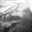
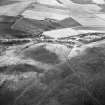
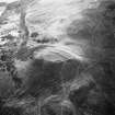
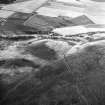
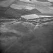
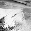
(NT 2452 6620) A fort situated in a strong defensive position on the summit of a 20-30' high knoll to the E of Caerketton Hill, c. 1100' OD. It has consisted of an inner wall, marked only by a line of outer facing stones, untrimmed boulders c. 18" long, one course high on the N side, with a little stony core elsewhere, with an exterior wall or rampart on its more vulnerable western half: this lattter may have continued on its eastern side, but no trace is visible except for a terrace lying 15' below the inner wall on the W and S. The fort has been robbed of its stone and subsequently cultivated. The entrance on the N is probably original, but the gap on the E is more likely to be due to cultivation. The interior is featureless except for an oval depression which may be the site of a hut, and some slight traces of a quarry terrace behind the inner wall. This was doubtless a continuous feature.
RCAHMS TS, 12 April 1956
The remains of this fort are generally as described, except that no trace of facing stones or internal features can now be seen.
Surveyed at 1/2500.
Visited by OS (RD) 6 January 1970
No change to previous information.
Visited by OS (BS) 8 December 1975
NT 245 662 A coarse stone tool was recovered from the W rampart of the small hillfort at Hillend and donated to NMS (HH 972).
F Hunter 1999
Field Visit (26 November 1928)
Fort, Hillend Hill.
Just behind an old quarry on Hillend Hill and on the crest of a small spur of the Pentland Hills, which juts out from the base of Caerketton Hill at the north-east, there are some traces of a fort. These lie at an elevation of slightly over 1000 feet above sea level and enclose an area approximately 200 feet in diameter. The details are completely destroyed on the east side, but they are somewhat better preserved at the west and south-west, where a short section indicates that there had been at least two lines of defence about 12 feet apart. The outer line is at a level of about 8 feet lower than the inner line and roughly 15 feet higher than the level outside. These ramparts can also be traced around a portion of the northside, but the details are less clearly defined. In one portion of the inner defence, however, a row of fairly large stones, set edge to edge for a distance of about 35 feet, indicates that the defences were, in part at least, of stone. There are no very clear indications of an entrance, but it was possibly from the north.
RCAHMS 1929, visited 26 November 1928.
vii S.E. (unnoted).
Field Visit (12 April 1956)
This site was included within the RCAHMS Marginal Land Survey (1950-1962), an unpublished rescue project. Site descriptions, organised by county, are available to view online - see the searchable PDF in 'Digital Items'. These vary from short notes, to lengthy and full descriptions. Contemporary plane-table surveys and inked drawings, where available, can be viewed online in most cases - see 'Digital Images'. The original typecripts, notebooks and drawings can also be viewed in the RCAHMS search room.
Information from RCAHMS (GFG) 19 July 2013.
Note (1988)
Hillend NT 2451 6621 NT26NW 20
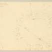
This fort is situated on a knoll on the NE flank of Caerketton Hill. It measures about 70m by 50m internally, although all that is visible of its rampart is a low mound on the Wand N. On the W, the easiest line of approach, there is a stretch of outer ditch with an external bank set some 4m below the crest of the knoll. A 3m wide gap in the rampart on the N, now used by the modern path to the top of the knoll, may mark the position of an original entrance, but a natural hollow which runs up into the interior from the SE also provides good access. Traces of a possible timber house site about 5m in diameter can be seen at the Send of a rocky ridge that bisects the interior of the fort.
RCAHMS 1988
(RCAHMS 1929, 115-16, no. 143; RCAHMS Survey of Marginal Lands)
Note (5 November 2015 - 4 August 2016)
This fort occupies a knoll forming the summit of a spur that juts out NE from the E flank of Caerketton Hill. Almost sub-rectangular on plan, it has measured internally about 70m from E to W by 53m transversely, but its rampart has been largely demolished, leaving little more than a faint terrace along the lip of a rocky external scarp some 4.5m in height to mark its course. A terrace at the foot of this scarp around the W end, from the NW round to the S, interpreted by RCAHMS investigators in 1956 as the remains of an outer wall or rampart, gives the impression of a cut feature, and indicates that some attempt had been made to strengthen the defences facing onto the saddle linking the knoll to Caerketton Hill. Although the investigators identified a shallow depression in the SE quadrant, the interior has been cultivated and appears featureless. The entrance is probably on the N, while a broader gap on the E is likely to be the result of cultivation.
Information from An Atlas of Hillforts of Great Britain and Ireland – 04 August 2016. Atlas of Hillforts SC3706

