
Dreva Craig


Chevaux De Frise (Prehistoric), Fort (Prehistoric), Roundhouse(S) (Prehistoric)
Site Name Dreva Craig
Classification Chevaux De Frise (Prehistoric), Fort (Prehistoric), Roundhouse(S) (Prehistoric)
Canmore ID 49881
Site Number NT13NW 8
NGR NT 1267 3533
Datum OSGB36 - NGR
Permalink http://canmore.org.uk/site/49881


- Council Scottish Borders, The
- Parish Stobo
- Former Region Borders
- Former District Tweeddale
- Former County Peebles-shire
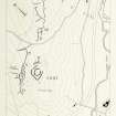
NT13NW 8.00 1267 3533
NT13NW 8.01 NT 1273 3538 Settlement
NT13NW 8.02 NT 1256 3540 Settlement
NT13NW 8.03 NT 1244 3500 Settlement
NT13NW 8.04 Centred NT 128 355 Field-System
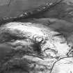
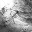
(NT 1267 3533) Fort & Settlement (NR)
OS 6" map, (1968).
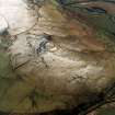
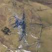
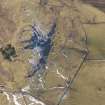
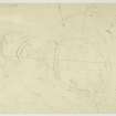
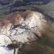
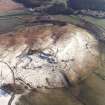
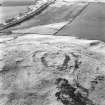
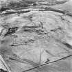
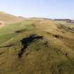
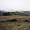
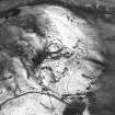
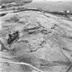
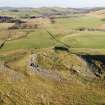
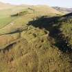
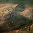
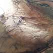
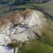
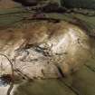
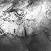
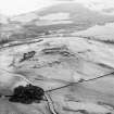
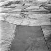
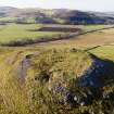
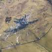
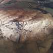
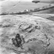
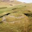
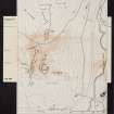
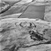
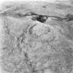
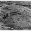
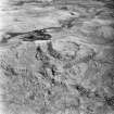
The group of remains on Dreva Craig comprises (i) a fort, defended by two stone walls and "chevaux de frise"; (ii) three settlements (see NT13NW 8.01 , 8.02, & 8.03); (iii) a field system (NT13NW 804). A fourth settlement is earlier in date than the other three, and is described on NT13NW 23. (See RCAHMS 1967 plans, figs.90, 91).
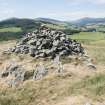
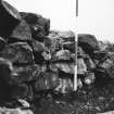
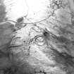
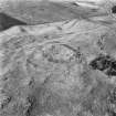
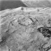
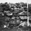
The inner wall (A) of the fort encircles the summit-area of the knoll, a tilted plateau measuring 185' x 140' which falls 24' from NW to SE in a series of low rocky terraces. The wall measures 12' - 14' in thickness at the base and is of stone construction throughout, the core being solidly packed with stones and faced on both sides with boulders. The entrance coincides with a natural gully cutting into the ESE margin of the plateau and measures 12' in width. The interior exhibits no trace of primary dwellings, but a secondary occupation is indicated by the presence, partly in the inner edge of the debris of the wall, of four stony rings (1-4) and a fragment of another (5), representing the foundations of houses measuring internally 17' in diameter. What may be the remains of another similar house (6) occupy one of the natural terraces.
The outer wall (B), which is similar in construction to A and measures about 12' in thickness, lies close to the base of the knoll. On the SW, where the distance between the two walls reaches a maximum of 100', an intrusive oval drystone foundation, measuring internally 23' x 18', impinges upon the inner margin of the debris of B. Erosion and stone-robbing have virtually obliterated the NE sector of B in which the main entrance, linked by an inclined pathway to A, was situated. A second entrance, on the N, set at a right angle to B, gives access to the space between the two walls.
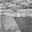
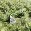
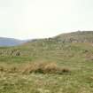
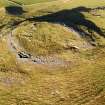
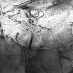
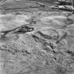
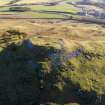
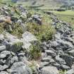
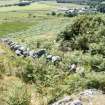
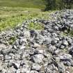
The chevaux de frise (C) occupy an area measuring about 100' x 70' in extent on the flat top of the spur, a short distance outside the SW sector of the outer wall B. Although to some extent robbed, they still comprise about 100 upright earthfast boulders in situ, with as many more either appearing as broken stumps or lying loose in the grass, and must originally have formed an obstacle which would have served to break up a mass of attackers advancing from the SW apex of the spur.
The possibility that the opposite (NE) end of the fort was also protected by chevaux de frise is suggested by the presence, among the structures forming settlement X, of several upright earthfast boulders which appear incongruously large in comparison with the other stones in this area. (The settlement referred to by the RCAHMS is described on NT13NW 8.01).
RCAHMS 1967, visited 1958; D Christison 1887; Information from R W Feachem notebook No.14, 1958.
This fort is generally as described.
Revised at 1:2500.
Visited by OS(EGC) 19 June 1964 and (BS) 18 November 1974.
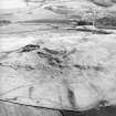
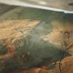
The fort is visible on large scale vertical air photograph (OS 71/395/062, flown 1971).
Information from RCAHMS (RJCM) April 1992
NT 1299 3555 A watching brief was carried out in January 2004 prior to the construction of an extension to an existing telecommunications mast within the Dreva Craig hillfort complex (NT13NW 8). Owing to the sensitivity of the area, a temporary road was laid to gain access to the site. This work was monitored to ensure that no impact by vehicles affected upstanding field banks associated with the hillfort's ancillary settlement. Work at the extension to the base of the telecommunications mast revealed no archaeological finds or structural remains.
Report lodged with Scottish Borders SMR.
Sponsor: ntl Group Ltd.
M Cressey 2004
Publication Account (1985)
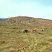
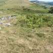
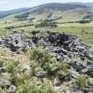
Dreva occupies a prime site, a rocky outcrop providing clear views both up and down the Tweed valley and westward to the broad and fertile bowl amongst the hills that contains the attractive village of Brought on and the key through-route to the upper Clyde-the Biggar Gap. A twin protector, Tinnis Castle and Fort (NT 141344) stands opposite, just east of Drumelzier.
Built of stone, the fort consists of two walls, each up to 4.3m thick at the base, faced on both sides with boulders and packed internally with stones. Whilst there is no evident contemporary settlement, secondary occupation within the inner wall is indicated by four stony rings and a fragment of a fifth built partly into the inner edge of-debris from the wall. The entrance is by a natural gully to the east-southeast, over 3.5m wide. Of the outer rampart most survives in an area north-west by west to south-west.
The remarkable thing about Dreva is that its prominent position evidently outweighed its relative lack of natural defences. Such shortcomings were alleviated, however, by a feature that is rare in Scotland: the chevaux de frise. About 100 stones, protecting access up the south-west slope beyond the outer wall, still stand upright over an area of some 650 square metres; many more, either broken stumps or lying loose in the grass, must have made this instrument of defence a formidable obstacle to horsemen or chariots-or even attackers on foot. And there may well have been a similar jagged barrier on the opposite north-east side, given the number of large upright boulders scattered amongst the remains of a later settlement.
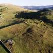
This later settlement (NT 127353) and the one below the north-west side of the fort (NT 125353) were undefended. Below the latter, and extending across the road along the slope, is a fragmentary but clearly identifiable field-system (NT 125354-130357) which even now covers over 10 ha. Although the original shapes and sizes of the fields are lost, the remnants suggest 'Celtic' fields, as at Glenrath Hope (no. 88).
Beyond, on the lower slopes of Trehenna Hill, the considerable numbers of cultivation rigs are perhaps 18th century: they are not as wide, high and sinuous as earlier rigs.
Information from 'Exploring Scotland's Heritage: Lothian and Borders', (1985).
Note (8 October 2015 - 18 May 2016)
This fort crowns the rocky summit of Dreva Craig, which forms the SW spur of Dreva Hill. The defences comprise two walls, which follow eccentric courses, the inner crowning the summit area, and the outer extending round a lower terrace, and there are have also been belts of chevaux de frise set out across the easiest lines of approach on the NE and SW. The inner enclosure, which has the appearance of a citadel, is oval on plan and measures about 56m from E to W by 43m transversely (0.18ha) within a massive wall between 3.6m and 4.3m in thickness; on the WNW the wall has completely collapsed down the slope, but elsewhere portions of the faces are visible, particularly on the SW, which has suffered from misguided attempts at rebuilding. At least three stone-founded round-houses are visible within the interior, though these need not be contemporary with the defences. The entrance is on the E, adapting a cleft in the rocks from below which a natural ramp descends towards the NE, presumably making for a gap in the outer wall, though little trace of it survives in this sector. The outer enclosure is roughly rhomboidal on plan, measuring a maximum of 115m from NE to SW by 85m transversely (0.64ha), and in addition to the entrance described above, which lies at its NE apex, there is also a second on the NNW where the terminals of the wall overlap to expose the visitor's left side. Unlike the other entrance, which gives access to the inner enclosure, this entrance only serves the outer and is possibly evidence that it was originally conceived as a separate defensive scheme. The belts of chevaux de frise are set across the approaches to this lower wall. That on the SW is the better preserved, the stones having been partly cleared on the NE to make way for a later settlement of stone-walled round-houses and enclosed yards. Evidently later than the fort defences, this is just one of a number of other settlements on the hill, including an extensive cluster of scooped courts and yards associated with a field-system extending along the NW flank of the hill.
Information from An Atlas of Hillforts of Great Britain and Ireland – 18 May 2016. Atlas of Hillforts SC3577
Sbc Note
Visibility: This is an upstanding earthwork or monument.
Information from Scottish Borders Council

