
Castle Hill, St Ninian's Chapel


Chapel (Medieval)(Possible), Redoubt (17th Century)(Possible)
Site Name Castle Hill, St Ninian's Chapel
Classification Chapel (Medieval)(Possible), Redoubt (17th Century)(Possible)
Canmore ID 49517
Site Number NT08SE 7
NGR NT 0548 8012
Datum OSGB36 - NGR
Permalink http://canmore.org.uk/site/49517


- Council Falkirk
- Parish Bo'ness And Carriden
- Former Region Central
- Former District Falkirk
- Former County West Lothian
NT08SE 7 0548 8012.
(NT 0548 8012) St Ninian's Chapel (NR) (Remains of) (Not on 1st edn 6"map, 1856)
OS 25"map, (1954)
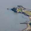
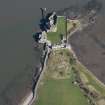
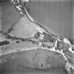
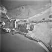
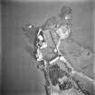
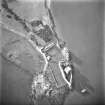
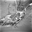
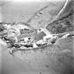
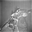
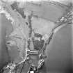
Redoubt (site of): The summit of the hillock immediately S of Blackness Castle bears traces of an extensive work noted on a plan of 1725 (Plan held in Kings library, British Museum) as "the remains of a redoubt built by ye English when they were masters of Scottland". The masonry where visible appears to be 16th - 17th century work.
RCAHMS 1929, visited 1926.
The building foundation on Castle Hill, oriented WNW-ESE, measures 20.0m x 7.3m over rubble walls 0.8m thick and between 0.3m and 0.9m high. A wing 5.0m wide projects 4.3m to the SE. This would not appear to be the remains of a chapel. It has been preserved by the DoE.
Visited by OS (J L D) 19 January 1953.
The structure whose foundations can still be seen on Castle Hill, immediately S of Blackness Castle, has the appearance of a chapel and is presumably the St Ninian's Chapel referred to in a charter of 1466 (Reg Magni Sig Reg Scot 1984). It does not appear to bear any resemblance to a redoubt.
Information contained in letter from K A Steer, RCAHMS to OS 11 June 1958.
A Celtic cult figurine (NT08SE 12) may have come from this site (but also see NT08SE 10).
A Ross 1967.
The foundations are as described by previous OS field surveyor.
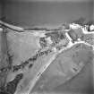
Footings of other walls exist adjacent to the site on the N but form no intelligible plan. These foundations are not shown on an estate plan of 1837 although the dovecot is (Estate plan 1837, R H P 1706, West Register House) The whole area is Crown property.
Visited by OS (B S) 14 March 1974.
The site is located on Castle Hill immediately south of the main Blackness Castle buildings. There are foundations of a rectangular structure here which has in the past been identified as a possible chapel or as a redoubt. The site is a Crown Property. There are no changes to NMRS description of 1974. The foundations are still visible.
Site recorded by GUARD during the Coastal Assessment Survey for Historic Scotland, 'The Firth of Forth from Dunbar to the Coast of Fife' 24th February 1996..
Field Visit (August 1977)
Blackness, St Ninian’s Chapel NT c. 054 801 NT08SE 7 and NT08SE 10
A pre-Reformation chapel at Blackness is recorded in a charter of 1466; the altar is said to have been still visible at the E end of the village in 1902. The location of this chapel is uncertain, but it may have stood in the vicinity of the later redoubt lying immediately to the S of Blackness Castle, where there may be seen the footings of a small oblong building aligned upon a WNW to ESE axis.
RCAHMS 1978, visited August 1977
(RCAHMS 1929, p.125)

