Pricing Change
New pricing for orders of material from this site will come into place shortly. Charges for supply of digital images, digitisation on demand, prints and licensing will be altered.
Limekilns Harbour
Harbour (Period Unassigned)
Site Name Limekilns Harbour
Classification Harbour (Period Unassigned)
Alternative Name(s) Limekilns, Harbour; Limekilns Pier; Gellaid
Canmore ID 49487
Site Number NT08SE 23
NGR NT 0755 8330
NGR Description Centred NT 0755 8330
Datum OSGB36 - NGR
Permalink http://canmore.org.uk/site/49487
- Council Fife
- Parish Dunfermline
- Former Region Fife
- Former District Dunfermline
- Former County Fife
NT08SE 23.00 centred 0755 8330
NT08SE 23.01 Centred NT 0758 8312 The Ghauts [natural feature]
NT08SE 23.02 NT 07496 83308 Pier
NT08SE 23.03 NT c. 0757 8338 Sluicing-pond
NT08SE 23.04 NT c. 0748 8338 Sluicing-pond
Not to be confused with Bruce Haven, Capernaum Pier (NT 07940 82949), for which see NT08SE 22.
Not to be confused with Charlestown Harbour (NT08SE 31.00), which is also known as Limekilns Harbour.
Location formerly entered as NT 0749 8332 and NT 07496 83308.
(Location cited as NS [NT] 075 833). Limekilns: no date can be suggested for the origin of the port of Limekilns, but shipping is likely to have used this comparatively sheltered tidal anchorage inside the 'Ghauts' or 'Goat Rocks' [name centred NT 0758 8312], at any period of the past. The records first mention Limekilns, under the name of 'Gellaid' in 1362, when David II gave the port to Dunfermline Abbey (NT08NE 1.00). At that time it must already have been a going concern, with an established trade in wool, skin and hides. Later records are fairly numerous, although they make no mention of the harbour installations. At the end of the 17th century, the harbour was 'commodious' for the shipping of coal, and Roy's map of Scotland (1747-55) marks a pier in the middle of the bay.
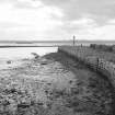
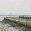
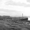
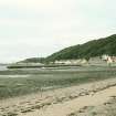
The harbour area is a large tidal pocket, enclosed to seaward by the Ghauts and on the E by low bank of shingle interspersed with flat rocks, and partially covered on the W by the pier (NT08SE 23.02), which is probably the same as the one marked by Roy whatever changes may have been made to it since his time. This pier runs straight out seawards, its head being separated from the Ghauts by about 120yds [109.8m] of mud; its length is 230ft [70.1m] on the W, but more on the E, where its face turns into a sea-wall revetting a roadway, and its average breadth 65ft [19.8m]. The masonry is of rather roughly squared dry-stone blocks, but its end, which seems to have been rebuilt, is mortared and has a flight of steps on its E side. The surface is grassed over and carries three light wooden pawls at its end; its landward portion is divided longitudinally in the centre by a wall 109ft [33.2m] long, built in 1870 to shelter craft moored on the E. A pond [NT08SE 23.03] for use in scouring mud out of the harbour formerly existed about 80yds [24.4m] E of the pier, where the house called Carey now stands NT c. 0757 8338]; another [NT08SE 23.04], now also vanished, is marked [at NT c. 0748 8338] on the OS 6-inch map of 1854, just W of the landward end of the pier.
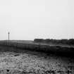
The Ghauts (NT08SE 23.01) are formed by a low ridge of rock, which runs from ENE to WSW, and separates the harbour area from the Firth. The ridge has been cut through to make an entry for ships, the passage being about 150ft [45.7m] by up to about 90ft [27.4m] wide; the width, however, is difficult to estimate on account of collapsed stonework. On the W side of the cut, the roughly trimmed rock-face stands up to 5ft [1.5m] in height, with a built wall, heavily battered, rising as much as 8ft [2.4m] in addition. The wall runs straight for about 120ft [36.6m] decreasing in height as the surface of the reef slopes downwards, but curves back at each end, its footings disappearing under fallen debris. There was once a quay here, flanking the cut, but its size is impossible to estimate as the top of the reef is widely strewn with boulders and tumbled stones, many of them roughly shaped. On the E side, the rock is again cut to a face up to 5ft [1.5m] high, with a wall up to 9ft [2.7m] high on top of it. The seaward end of this wall curves eastwards, and its footings return northward across the top of the reef, evidently defining a quay about 20ft [6.1m] wide. Mooring-posts survived on both quays at least until 1900. From the N end of this cut, the E wall or footings may be traced shorewards for about 230ft [70.1m] along the edge of the bank of shingle mentioned above, but it is stated locally that a breakwater originally followed this line all the way to the land, and in fact some suggestive traces may be seen from place to place on this alignment. The chief of these is a pier, running out from the sea-wall at a point about 90 yds [82.3m] E of the main pier, and now reduced to footings and the stumps of timber piles; this no doubt represents the pile-built structure that is said to have existed in the early 19th century. It seems to have been some 10ft [3m] to 12ft [3.7m] wide, and probably ended at a flat rock, the W side of which has been cut into, and which carries a massive iron ring. Again, beyond this rock and about 90yds [82.3m] from the land, there may be seen a large roundish patch of stones, heaped together and with large blocks lying round the circumference, which may possibly have been the base of some quayside structure.
A Graham 1971.
Site recorded by Maritime Fife during the Coastal Assessment Survey for Historic Scotland, Kincardine to Fife Ness 1996
This tidal harbour (in reality, little more than a simple pier) remains in regular use for recreational sailing.
Information from RCAHMS (RJCM), 31 March 2006.


