
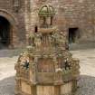
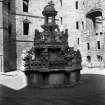
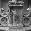
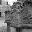
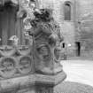
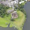
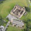
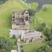
Linlithgow, Linlithgow Palace, Fountain


Fountain (16th Century)
Site Name Linlithgow, Linlithgow Palace, Fountain
Classification Fountain (16th Century)
Canmore ID 262603
Site Number NT07NW 9.06
NGR NT 00201 77347
Datum OSGB36 - NGR
Permalink http://canmore.org.uk/site/262603


First 100 images shown. See the Collections panel (below) for a link to all digital images.
- Council West Lothian
- Parish Linlithgow
- Former Region Lothian
- Former District West Lothian
- Former County West Lothian
NT07NW 9.06 0020 177347
NT 002 773 Fountain. Archaeological monitoring was undertaken in December 2002 during the excavation of a small test pit at the NW corner of the elaborate fountain in the Palace courtyard. The findings appear to reflect the construction of the fountain over an earlier cobbled surface, at a depth of 400mm below the present surface. The cut against the early cobbles is most likely associated with the fountain construction - possibly a foundation trench. The cut and its fill were sealed by two levelling deposits, also likely to be part of the original construction of the fountain.
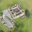
Further monitoring was undertaken in March 2003 while a trench was excavated against the E side of the fountain. The courtyard has been resurfaced in modern times with the result that the upper levels in the section are of quite recent date. No earlier courtyard surfaces or structures were uncovered in the 1m deep excavation.
Archive to be deposited in the NMRS.
Sponsor: HS
G Ewart 2003
NT 0020 7734 An archaeological watching brief was maintained in September 2005 at the palace during the installation of new floodlights on the site. Trenches were dug where the existing cables for earlier lights had been laid, in order to cause as little disturbance as possible, and the new cables were laid where the original ones had been buried. No archaeological features or deposits were found in any of the trenches. A layer of concrete was found overlying a pebble layer, which lay on top of the subsoil.
Archive to be deposited in NMRS. Report lodged with local authority and NMRS.
Sponsor: West Lothian Council.
R Will, 2006.
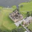
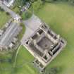
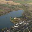
NT 0028 7734 to NT 0035 7727 On the E side of the lower path approaching the NE angle of the Palace, fallen leaves in November-December 2005 indicated six long, shallow, parallel hollows, running in a general NW to SE direction, that of the path and the edge of the scarp. These features extended for around 120 x 21m, on a slope gently descending to the NE. At the N end was a shallow bank 3m wide x 19m long, angled almost SW to NE. The hollows were between 0.9m and 1.2m wide and between 7m and 2m apart, stopping short of the shallow bank. About 60m SE of the shallow bank, a circular feature, possibly a tree-hole, cut the fifth hollow from the path. W of the path, between it and the scarp, there is a terrace, around 10m wide, with suggestions of similar hollows cut into it.
C A Kelly, 2006.
Excavation (12 December 2002)
NT 002 773 Fountain. Archaeological monitoring was undertaken in December 2002 during the excavation of a small test pit at the NW corner of the elaborate fountain in the Palace courtyard. The findings appear to reflect the construction of the fountain over an earlier cobbled surface, at a depth of 400mm below the present surface. The cut against the early cobbles is most likely associated with the fountain construction - possibly a foundation trench. The cut and its fill were sealed by two levelling deposits, also likely to be part of the original construction of the fountain.
Further monitoring was undertaken in March 2003 while a trench was excavated against the E side of the fountain. The courtyard has been resurfaced in modern times with the result that the upper levels in the section are of quite recent date. No earlier courtyard surfaces or structures were uncovered in the 1m deep excavation.
G Ewart 2002
Sponsor: Historic Scotland
Kirkdale Archaeology
Excavation (25 March 2003 - 27 March 2003)
NT 002 773 Fountain. Archaeological monitoring was undertaken in December 2002 during the excavation of a small test pit at the NW corner of the elaborate fountain in the Palace courtyard. The findings appear to reflect the construction of the fountain over an earlier cobbled surface, at a depth of 400mm below the present surface. The cut against the early cobbles is most likely associated with the fountain construction - possibly a foundation trench. The cut and its fill were sealed by two levelling deposits, also likely to be part of the original construction of the fountain.
Further monitoring was undertaken in March 2003 while a trench was excavated against the E side of the fountain. The courtyard has been resurfaced in modern times with the result that the upper levels in the section are of quite recent date. No earlier courtyard surfaces or structures were uncovered in the 1m deep excavation.
G Ewart 2003
Sponsor: Historic Scotland
Kirkdale Archaeology
Watching Brief (8 September 2004 - 19 October 2004)
In September and November 2004 Kirkdale Archaeology undertook a Watching Brief as work was done on the Fountain at Linlithgow Palace.
G Ewart 2004
Sponsor: Historic Scotland
Kirkdale Archaeology
Field Visit (November 2005 - December 2005)
NT 0028 7734 to NT 0035 7727 On the E side of the lower path approaching the NE angle of the Palace, fallen leaves in November-December 2005 indicated six long, shallow, parallel hollows, running in a general NW to SE direction, that of the path and the edge of the scarp. These features extended for around 120 x 21m, on a slope gently descending to the NE. At the N end was a shallow bank 3m wide x 19m long, angled almost SW to NE. The hollows were between 0.9m and 1.2m wide and between 7m and 2m apart, stopping short of the shallow bank. About 60m SE of the shallow bank, a circular feature, possibly a tree-hole, cut the fifth hollow from the path. W of the path, between it and the scarp, there is a terrace, around 10m wide, with suggestions of similar hollows cut into it.
C A Kelly 2006
Watching Brief (September 2005)
NT 0020 7734 An archaeological watching brief was maintained in September 2005 at the palace during the installation of new floodlights on the site. Trenches were dug where the existing cables for earlier lights had been laid, in order to cause as little disturbance as possible, and the new cables were laid where the original ones had been buried. No archaeological features or deposits were found in any of the trenches. A layer of concrete was found overlying a pebble layer, which lay on top of the subsoil.
Archive to be deposited in NMRS. Report lodged with local authority and NMRS.
Sponsor: West Lothian Council.
R Will 2006

