
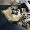
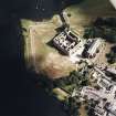
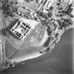
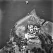
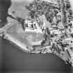
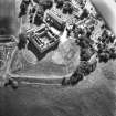
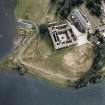
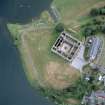
Linlithgow Palace


Cropmark(S) (Period Unknown), Enclosure (Period Unassigned)(Possible), Temporary Camp (Roman)(Possible)
Site Name Linlithgow Palace
Classification Cropmark(S) (Period Unknown), Enclosure (Period Unassigned)(Possible), Temporary Camp (Roman)(Possible)
Canmore ID 71540
Site Number NT07NW 85
NGR NT 0015 7733
Datum OSGB36 - NGR
Permalink http://canmore.org.uk/site/71540


- Council West Lothian
- Parish Linlithgow
- Former Region Lothian
- Former District West Lothian
- Former County West Lothian
NT07NW 85 0015 7733
RCAHMS aerial survey has recorded the NW rounded angle of what appears to be a single-ditched rectangular enclosure, in the parched lawns immediately SW of the SW corner of the palace. The site has had a long history of fortification, but the present parch-mark would not be out of place in a Roman context. First-century Roman material is recorded c.100m to the SE (NT07NW 10).
S S Frere 1990.
Publication Account (17 December 2011)
A rounded corner angle and stretches of two adjacent sides were recorded in 1989 by RCAHMS from the air (Frere 1990: 312). These appear as parch marks southwest of Linlithgow Palace. It has been proposed that it is part of a Roman structure (Frere 1990: 312) but further evidence is required before it can be confirmed as being Roman in date, and before it can be ascertained whether the structure was temporary or permanent.
R H Jones.

