
Kinnelhead Tower


Cross Incised Stone(S) (Medieval), Fortified House (Medieval)
Site Name Kinnelhead Tower
Classification Cross Incised Stone(S) (Medieval), Fortified House (Medieval)
Alternative Name(s) Peat Hill
Canmore ID 48432
Site Number NT00SW 1
NGR NT 02788 01682
Datum OSGB36 - NGR
Permalink http://canmore.org.uk/site/48432


- Council Dumfries And Galloway
- Parish Kirkpatrick-juxta
- Former Region Dumfries And Galloway
- Former District Annandale And Eskdale
- Former County Dumfries-shire
NT00SW 1 02788 01682
(NT 0278 0168) Kinnelhead Tower (NR) (remains of)
OS 6" map, (1962)
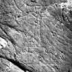
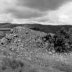
Structure and Incised Cross, Kinnelhead: On the NE shoulder of Peat Hill adjacent to Kinnelhead farm (NT00SW 28) is a ruinous structure of indeterminate date. On the hillside are many outcrops of rock; a cleft in one has been artificially extended and incorporated in a building. This cleft runs approximately N-S; across its N end a gable wall has been erected; there are traces of a similar wall at the S end. A vaulted roof has been thrown across from the rock face on the E to that on the W. There has been at least one other storey above the vault. The building measures 50' (15.2m) N-S x 23'2" (7.1m) E-W; the walls are 4' (1.2m) thick. It is much longer than the usual domestic or domestic-and-defensive building. On the rock to the W of the building is incised a Cross Calvary. It measures 3 1/4" (83mm) across the arms and is 10 1/2" (266mm) high. The workmanship is crude. Taking these points into consideration would suggest an ecclesiastical purpose for the building. Some 34' (10.4m) to the W is an outbuilding running parallel to the main structure. It is built of drystone masonry, some of the stones weighing more than a ton. To the N and E are traces of other buildings.
RCAHMS 1920, visited 1912.
The remains of Kinnelhead are in many respects identical to those of Lochwood (NY09NE 8), a peel tower with barmekin surround containing buildings, but more ruinous and crudely built. At both places there is a vaulted basement placed at the corner of a rectangular courtyard round the interior of which are the remains of buildings. If the cross, of a design familiar to the 14th and 15th centuries (M E Kuper 1884) is considered, this may be a church or ecclesiastical structure. Otherwise, it seems probable that the building was occupied at the close of the 16th century by a branch of the Johnstone family.
Trans Dumf Galloway Natur Hist Antiq Soc 1926
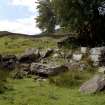
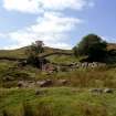
The remains at Kinnelhead are generally as described. The main structure is a strongly-built structure measuring 17.0m NE-SW by 7.6m with mortared rubble walls 1.7m thick. The S gable remains almost entire containing two narrow splayed windows near the present ground level. The walls are in a dilapidated condition and rise little above the surrounding ground level, except for the SW gable. Lying parallel to this structure and c. 10.0m NW of it are the scant remains of a similar building. The walls, where standing, are 1.0m high.
A rectangular enclosure measuring 20.0m x 21.0m forms a courtyard on the NE side of the buildings. This wall is built of massive stones and measures 1.7m wide by 1.0m high.
Lying c. 12.0m E of the NE angle of the courtyard are the foundations of a small square building which measured 7.0m by 6.5m.
To the W of the main building, on a sloping rock face, is the small incised Latin cross described earlier.
The dimensions and situation of this building and its contemporaries are not suggestive of a tower, but the massive construction of its walls and the presence of splayed windows suggest a possible 16th c. date for the structure, and would be in keeping with strongholds of this period.
Visited by OS (W D J) 3 September 1959
Revisited. Site confirmed
Surveyed at 1:2500.
Visited by OS (D W R) 20 September 1973
Measured Survey (15 August 1990)
RCAHMS surveyed Kinnelhead Tower fortified house on 15 August 1990 with plane-table and self-reducing alidade at a scale of 1:500. The site plan was redrawn in ink and published at a scale of 1:1000 (RCAHMS 1997, Fig. 228).
Field Visit (21 June 1991)
NT00SW 1 02788 01682
Two substantial stone buildings with an attached enclosure are situated at the foot of an area of boulder-strewn ground to the W of Kinnelhead steading (NT00SW 28); three incised crosses have been identified on outcrops in the vicinity. The buildings and the adjacent rock outcrops have been linked by a substantial stone wall to form a roughly square enclosure. The entrance to the split-level enclosure is on the SE, and the two buildings are ranged to either side of the upper, raised yard on the SW.
The major building, a hall-like structure, occupies the SE side of the upper yard and measures 15m from NE to SW by 8m overall. It utilises a natural cleft in the rock outcrop whose sheer sides provide the greater part of the walls for the ground floor. The walls are of mortared rubble above the outcrops. There is an entrance at first-floor level in the NW wall (secured by a pair of draw-bar slots), a high-level window in the SW end wall and, although the NE end-wall has been almost entirely removed, it is likely that there was an entrance into the ground floor at this point. The interior of the building was vaulted to produce what was in effect an entresol floor at first-floor level, and the absence of a scarcement implies that the floor must have been supported on vertical wall-posts.
The adjacent building measures 17m from NW to SE by 7.5m transversely over walls up to 1.6m thick and was also entered directly from the courtyard. It is remarkable for the scale of its surviving masonry, which is also a feature of the wall closing the yard on the SW. A sump, fed from a burn, is situated on the SW side of the yard, and run-off appears to be channelled beneath the partially-paved yard surface to exit the yard on the NE.
On the rock outcrop beside the entrance to the main building, there is an incised Calvary Cross. A second cross of similar form has been incised on a boulder beside the prominent rock outcrop to the W (NT 0276 0168), whilst higher up on the outcrop itself, and some 5m to the E, there is a and incised Greek cross with wedge-shaped arms. These crosses are probably of late medieval date, but no reason has been found to account for their presence.
Kinnelhead is first documented in 1529, when one portion of the property formed part of the 42 pound land in which the widow of the 3rd Lord Carlyle was granted a liferent interest. Another portion of the Kinnelhead (probably that on which the buildings stand), in the parish of Dumgree, formed part of the barony of Anisfield. In 1608 it was tenanted by the Johnstons; the family appears to have acquired the tenancy some time in the mid- to late-16th century. David Johnston, tenant of Kinnelhead, who died in 1612, is on record as a prosperous farmer and a merchant. He was succeeded by his son who died in 1629. In 1662 the two properties were united to form part of the newly-erected Earldom of Annandale and Hartfell, a situation which pertained until 1965. The author of the New Statistical Account notes that there was 'lately one vaulted ruin at Kinnelhead'.
Visited by RCAHMS (IMS, PC), 21 June 1991.
NSA 1845.
Listed as bastle (possible) and cross-incised rocks.
RCAHMS 1997.
Measured Survey (11 March 1991)
RCAHMS surveyed the ground- and first-floor of Kinnelhead Tower on 11 March 1991 producing plans and a section at a scale of 1:100. The first-floor plan and section were redrawn in ink and published at a scale of 1:200 (RCAHMS 1997, Fig. 228).
Desk Based Assessment (September 2009 - February 2015)
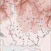
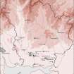
CFA Archaeology Ltd undertook an assessment of the potential effects of the proposed Harestanes Windfarm Extension on cultural heritage.
There are no predicted direct effects on cultural heritage sites within the Development Area. The Development layout has been designed so as to avoid upstanding cultural heritage sites and features recorded within the Development Area.
Eight Shepherds Cairns (54-58 and 114-116), that lie in close proximity to Development infrastructure, will be visibly marked off during construction work to avoid any accidental damage occurring to the remains during construction activities carried out in close proximity.
Funder: Land Use Consultants Ltd
CFA Archaeology Ltd

