
Lochhouse Tower


Tower House (Medieval)
Site Name Lochhouse Tower
Classification Tower House (Medieval)
Alternative Name(s) Moffat; Beattock Station; Lockhouse Tower
Canmore ID 48378
Site Number NT00SE 18
NGR NT 08164 03359
Datum OSGB36 - NGR
Permalink http://canmore.org.uk/site/48378


- Council Dumfries And Galloway
- Parish Kirkpatrick-juxta
- Former Region Dumfries And Galloway
- Former District Annandale And Eskdale
- Former County Dumfries-shire
NT00SE 18 08164 03359
For adjacent building (NT 0810 0338), see NT00SE 42.
(NT 0817 0335) Lochhouse Tower (NR)
OS 6" map, (1957)
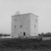
This tower, situated within a mile of Beattock Station (NT00SE 64), is a fair example of a Border pele. It stands on the brow of a slight hillock, two sides of which were formerly washed by a loch which is now drained away. The tower is 38 ft (11.6m) by 28 ft (9m) with walls 6 ft (1.8m) thick, rounded on the angles.
The entrance door is placed in the E wall, so as to be convenient for the newel staircase in the NE angle. The ground floor is vaulted, and provided with shot-holes. This floor could be used either as a refuge for cattle, or for stores. On the first floor is the hall which measures 27 ft (8.2m) by 16 ft 6 ins (5m) and has a window in each wall. The second floor was probably all in one apartment, like the hall, and would form the private room of the proprietor. Above this was the parapet walk supported on cirbels, and rounded at the angles, but without angle turrets. There was also an attic floor, probably used by some of the family or etainers, who would then be ready for instantly manning the battlements in case of need. The external set-off, where the wall of the top storey is thinned, is not common. It goes all round the tower.
There seems to be no record of the erection of this tower, but, judging from its style, it was probably built in the 16th century. It belonged to the Johnstones of Corehead.
D MacGibbon and T Ross 1887.
Lochhouse Tower, which is still occupied, is a restored 16th century rubble-built tower. It was perhaps built about the time of the Act of Parliament of 1535; it is mentioned in 1567 as being occupied by a Johnstone. It is oblong on plan, with rounded corners. It measures 37ft by 27ft, with walls 6ft thick; the basement is vaulted. It stands three storeys high, with a flat roof; only the S gable of the garret remains. The interior has been much altered, though some original details have been revealed by recent work.
RCAHMS 1920, visited 1912; N Tranter 1965; W A J Prevost 1980.
Lochhouse Tower (name confirmed) is as described.
Visited by OS (D W R) 24 November 1971
The ruined 16th century tower of the Johnstones of Corehead was restored as a residence c. 1980. It has rounded corners and external offsets below the basement, double splayed gunloops and the third storey windows. The attic originally lay inside a vanished parapet for which the corbels remain. The tower measures 11m by 8.3m over walls 1.6m thick at the base. The entrance in the E wall is flanked by a staircase in the corner and a tiny porters' room in the side wall.
M Salter 1993
Lochhouse Tower stands on low-lying ground a mile S of Moffat, and was probably built in the 16th century by the Johnstones of Corehead, in Annandale.
Rubble built, it once had three storeys and an attic, and has the basement course often found in the Dumfries area. The angles are rounded. The walls are taken in a little above second-floor level. The parapet once rested on individual corbels.
There is a vaulted basement, now partitioned. The original door is in the E front, that in the S wall being a modern addition to give access to the part of the vault now used as a store. The section of gable remains. Lochhouse has been reroofed and completely altered internally, except for the turnpike stair in the NE angle, which is no longer in use.
M Lindsay 1994.
Tower house built for the Johnstones of that Ilk, probably in the early 16th century and certainly by 1562.
J Gifford 1996.
NT00SE 18 08164 03359
EXTERNAL REFERENCE:
SCOTTISH NATIONAL PORTRAIT GALLERY
'Country Life,' 10/01/1947, page 128.
Field Visit (3 September 1990)
NT 0817 0335 NT00SE 18
Lochhouse is a 16th-century tower-house. It is rectangular on plan with rounded angles and stands three stories and a garret in height. There is a plinth at ground level, a set-back at third-floor level, and a continuous corbel-course at the wall-head. The entrance-doorway is towards the W end of the N wall and opened to a newel-stair and mural chamber on the W and E respectively. The ground floor is vaulted. Although restored, there are a number of original openings and three wide-mouthed gun-loops. In the 17th century Lochhouse was the property of the Johnstones of Corehead.
Visited by RCAHMS (IMS) 3 September 1990.
(RCAHMS 1920; R W Reid 1924).
Listed as tower.
RCAHMS 1997.
Archaeological Evaluation (6 March 2021 - 7 March 2021)
Wardell Armstrong LLP (WA) was commissioned by the client Lightning Protection Services, to undertake an archaeological evaluation by trial trenching on land at Lochhouse Tower, Moffat, (NGR: NT 08167 03359). The evaluation was required as a pre-determination condition for planning consent. The evaluation was undertaken in accordance with a written scheme of investigation (WSI) produced in response to a brief prepared by Andrew Nicholson, archaeological advisor for Dumfries and Galloway County Council.
The archaeological evaluation was undertaken over two days on the 6th and the 7th April 2021 and comprised the excavation of two trenches. The investigation revealed a coarse stone embankment in the southern end of Trench 1, corresponding to a boundary seen on historic mapping, and likely originally formed the edge of the former loch south of the tower. Late medieval/early post medieval pottery sherds were recovered from around this embankment. No archaeological features were observed within Trench 2 to the eastern side of the tower.
Information from Wardell Armstrong LLP.

