
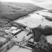
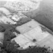
Bo'ness, Kinneil, Old Kinneil Kirk


Church (12th Century), Cross (11th Century)(Possible), Gravestone(S) (14th Century), Gravestone(S) (17th Century)
Site Name Bo'ness, Kinneil, Old Kinneil Kirk
Classification Church (12th Century), Cross (11th Century)(Possible), Gravestone(S) (14th Century), Gravestone(S) (17th Century)
Alternative Name(s) Kinneil Church; Kinneil Cross; St Catherine's Church
Canmore ID 48184
Site Number NS98SE 6
NGR NS 98093 80583
Datum OSGB36 - NGR
Permalink http://canmore.org.uk/site/48184


- Council Falkirk
- Parish Bo'ness And Carriden
- Former Region Central
- Former District Falkirk
- Former County West Lothian
NS98SE 6 98084 80579
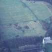
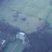
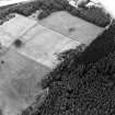
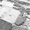
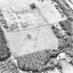
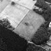
(NS 98084 80579) Church (NR) (remains of)
OS 6" map, (1969).
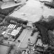
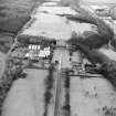
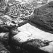
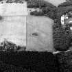
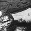
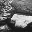
The earliest reference to Kinneil Church is in the mid-12th century; it was in use until c 1670, when Bo'ness became the parish church. The building was accidentally burned in 1745. Only the W gable and foundations of the remaining walls remain.
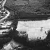
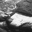
At the time of the MacGibbon and Ross survey, (D MacGibbon and T Ross 1897), the Duke of Hamilton had recently cleared part at least of the foundations of the church. He had discovered, they report, that it was "of Norman construction". No length is quoted; perhaps the E end was not found, but they refer to certain attached buildings on the N which, if they are not a misquotation referring to the S loft, have disappeared without trace.
In 1951, the foundations were cleared turf stripped from the interior, and minor excavations made. The plan of the church was found to be as shown by OS surveyor (JP). The nave and chancel were shown to be contemporary, with the loft a later addition. Possibly the S wall had been renewed, as there was apparently some difference in the masonry. Twenty inches under the present floor level, in the SE corner, beneath a late burial which had greatly disturbed it, there were traces of another floor level which was not found elsewhere, but the burials in the church made it impossible to search thoroughly. This floor level seems too low to have any connection with the present structure; there is no evidence whatsoever as to the nature of the occupation it represents.
Projecting through the wall of the loft was a stone mass later recognised as the head of a stone cross (see Dr J S Richardson's reconstruction drawing). This cross is described by J S Richardson as of "typical loose Norman composition" and he assumes a close connection between it and the church. The church is probably assignable to the second quarter of the 12th century, but there are obstacles to giving so late a date to the cross. The roods with which it can be compared are not numerous, and they belong, as Clapham established, to a late Saxon phase. The exact dating of this cross is not known.
RCAHMS 1929, visited 1926; A Clapham 1934; A Clapham 1951; D M Hunter 1967.
The remains of the church are as described and illustrated. The cross is now in Kinneil House.
Visited by OS (JP) 8 July 1974.
Field Visit (July 1977)
Kinneil NS 980 805 NS98SE 6
Fragment of medieval church which remained in use until about 1670 and was accidentally burnt in 1745. During excavations in 1951 part of a stone cross, which may be of earlier date than the church,was found; this is now at Kinneil House.
RCAHMS 1978, visited 1977
(MacGibbon and Ross 1896-7, iii, 578-9; RCAHMS 1929, pp. 189-90, No. 298; Hunter 1967)
Conservation (May 2014 - June 2014)
NS 9809 8058 As part of a community project in May–June 2014 the stone paving of the nave of Kinneil Church was cleaned and recorded, before being covered by imported topsoil and grassed over. It had previously been excavated in 1951 by Doreen Hunter, but was suffering from exposure. Seven 17thcentury and two 14th-century gravestones were drawn by local
volunteers and a report produced for Calatria.
Funder: Inner Forth landscape Initiative, Historic Scotland and Falkirk Community Trust
Geoff Bailey
(Source: DES)

