
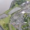
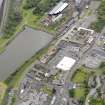
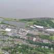
Bo'ness, Union Street, Harbour


Harbour (19th Century)
Site Name Bo'ness, Union Street, Harbour
Classification Harbour (19th Century)
Alternative Name(s) Mud Harbour; Bo'ness, Tidal Harbour; River Forth; Inner Forth Estuary
Canmore ID 144484
Site Number NS98SE 113
NGR NS 99938 81952
Datum OSGB36 - NGR
Permalink http://canmore.org.uk/site/144484


- Council Falkirk
- Parish Bo'ness And Carriden
- Former Region Central
- Former District Falkirk
- Former County West Lothian
NS98SE 113 99938 81952
Mud Harbour [NAT]
OS (GIS) MasterMap, June 2009.
For adjacent (to ESE) Bo'ness, Dock, see NT08SW 101.00.
For Bo'ness, West Pier (which forms the W side of this harbour), see NS98SE 196.
Extends onto map sheet NT08SW.
REFERENCE:
SCOTTISH RECORD OFFICE
Bo'ness, Pier
Lawsuit.
Additions to Pier.
Committee of inhabitants v William Shaw, mason.
[John Chalmers, architect, as cautioner]
1793
GD 124/6/304
(Undated) information in NMRS.
The harbour piers are late 18th century, the harbour [Bo'ness, Dock: NT08SW 101.00] was rebuilt in 1881.
Site recorded by GUARD during the Coastal Assessment Survey for Historic Scotland, 'The Firth of Forth from Dunbar to the Coast of Fife' 1996.
Characterisation
This site falls within the Industrial and Shoreline Area of Townscape Character (NT08SW 167), which was defined as part of the RCAHMS Urban Survey Programme 2013. Text relating to the historical development and topography, and present character of the Industrial and Shoreline Area of Townscape Character can be viewed at site NT08SW 167.
Information from RCAHMS (LK), January 2014

