
Wilsontown


Lade (18th Century) - (19th Century), Reservoir (18th Century) - (19th Century)
Site Name Wilsontown
Classification Lade (18th Century) - (19th Century), Reservoir (18th Century) - (19th Century)
Alternative Name(s) Wilsontown Ironworks
Canmore ID 99534
Site Number NS95SE 11.11
NGR NS 9516 5496
NGR Description From NS 9529 5581 to NS 9516 5496
Datum OSGB36 - NGR
Permalink http://canmore.org.uk/site/99534


- Council South Lanarkshire
- Parish Carnwath
- Former Region Strathclyde
- Former District Clydesdale
- Former County Lanarkshire
Field Visit (October 1994)
NS95SE 11.11 from 9516 5496 to 9529 5581
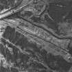
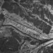
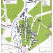
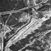
There is a subrectangular reservoir, now choked with reeds, in a forestry plantation to the E of Wilsontown Ironworks at NS 9516 5496 (CSW 1021). It is depicted on an 1826 map of Wilsontown Estate (National Library of Scotland, Map Library, ref. no. EMS.P.166), supplied by a lade which ran from another reservoir about 870m to the NNE at NS 9529 5581. Only part of this lade is still visible, surviving as a trench about 5.5m wide and 220m long from NS 9523 5536 to 9520 5514 (CSW 1040).
(CSW 1021, 1040)
Visited by RCAHMS (SDB) October 1994

