
Wilsontown


Building(S) (19th Century)
Site Name Wilsontown
Classification Building(S) (19th Century)
Alternative Name(s) Wilsontown Ironworks
Canmore ID 99528
Site Number NS95SE 11.06
NGR NS 9502 5512
Datum OSGB36 - NGR
Permalink http://canmore.org.uk/site/99528


- Council South Lanarkshire
- Parish Carnwath
- Former Region Strathclyde
- Former District Clydesdale
- Former County Lanarkshire
Field Visit (20 March 1996)
NS95SE 11.06 9502 5512
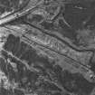
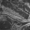
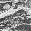
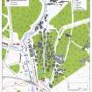
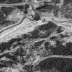
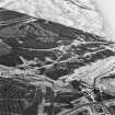
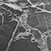
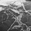
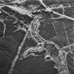
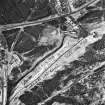
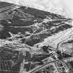
The slight remains of three rows of buildings survive in waste ground on either side of the Mouse Water and immediately N of the ruins of Wilsontown Ironworks. They are depicted on a map of the Wilsontown Estate (c.1826) (National Library of Scotland, Map Library, ref. no. EMS.P.166), and also appear, roofless, on the 1st edition of the OS 25-inch map (Lanarkshire 1864, sheet xx.2).
The most easterly of the three rows stood to the W of the current footpath at NS 9506 5512 (CSW 1037). The 1st edition map depicts a ten-compartment building, but only fragmentary traces remain. To the W of this, the 1st edition map appears to show a row of ten bridging the Mouse Water (CSW 1031, NS 9502 5512). There is, however, no evidence of a bridge on the steep banks of the burn, nor is one depicted on the 1826 map. On the E bank of the burn only two compartments survive, terraced into the slope, while on the W side a row of three compartments is visible, measuring 14m ENE-WSW by 6m transversely over walls 0.7m thick and 0.5m high. The third row is situated to the W (CSW 1035, NS 9497 5510), and measures 48m N-S by 4.8m over walls which have been reduced and spread. Nine compartments can be identified. At its N end, the early maps show a wing of four compartments projecting to the ENE, but only one compartment survives. To the S of the last row, the early maps show another terrace (CSW 1036, NS 9497 5502), but no trace of this survives: its N end is overlain by the remains of a later building, first depicted on the 2nd edition of the OS map (1897) and a conifer plantation covers the rest of it.
(CSW 1031, 1035-7)
Visited by RCAHMS (SDB) 20 March 1996

