
Wilsontown


Lime Kiln(S) (18th Century) - (19th Century), Mine Shaft (18th Century) - (19th Century)(Possible)
Site Name Wilsontown
Classification Lime Kiln(S) (18th Century) - (19th Century), Mine Shaft (18th Century) - (19th Century)(Possible)
Alternative Name(s) Wilsontown Ironworks
Canmore ID 99525
Site Number NS95SE 11.03
NGR NS 95003 55009
Datum OSGB36 - NGR
Permalink http://canmore.org.uk/site/99525


- Council South Lanarkshire
- Parish Carnwath
- Former Region Strathclyde
- Former District Clydesdale
- Former County Lanarkshire
Field Visit (20 March 1996)
NS95SE 11.03 9500 5500
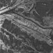
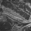
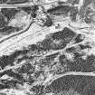
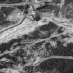
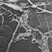
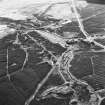
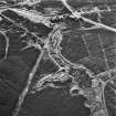
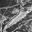
The remains of these limekilns are set into the top of the slope above the W bank of the Mouse Water, overlooking Wilsontown Ironworks. There have been at least two kilns, retained by a stone revetment wall, supported by a stone butress, which stands 3.2m high above the rubble at its foot. The top of one draw-arch is visible, with a depression in the ground behind it marking the position of the bowl. The second kiln, to the S, is marked by a large hollow, but the facade has collapsed at this point, and the arch does not survive. The revetment continues to the N, and two slight hollows in the ground behind it may indicate other kilns. About 20m to the N, at NS 9500 5504, there is a large hollow, which appears to be the top of a mine shaft.
Two disused kilns are depicted here on the 1st edition of the OS 25-inch map (Lanarkshire 1864, sheet xx.2). The possible shaft is also shown, although it is not annotated.
(CSW 1026)
Visited by RCAHMS (SDB) 20 March 1996

