
Wilsontown


Coke Oven(S) (18th Century) - (19th Century)
Site Name Wilsontown
Classification Coke Oven(S) (18th Century) - (19th Century)
Alternative Name(s) Wilsontown Ironworks
Canmore ID 99524
Site Number NS95SE 11.02
NGR NS 9500 5493
Datum OSGB36 - NGR
Permalink http://canmore.org.uk/site/99524


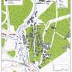
- Council South Lanarkshire
- Parish Carnwath
- Former Region Strathclyde
- Former District Clydesdale
- Former County Lanarkshire
Field Visit (20 March 1996)
NS95SE 11.02 9500 5493
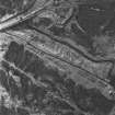
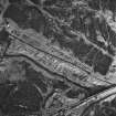
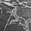
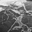
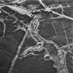
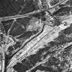
On the W edge of the ruins of Wilsontown Ironworks (NS95SE 11.01) there are the grassed-over remains of a row of coke kilns. The row measures 36.2m E-W by 5.5m overall, and appears to have consisted of eight bowls, each measuring about 3m in diameter, opening to the N and set against a bank about 3m high on the S. At the top of the bank, immediately above the four bowls in the E half of the row, there is a stone platform, measuring 16.9m E-W by 3.5m transversely and 0.5m in height, probably a loading platform.
A map of 1826 of the Wilsontown Estate (National Library of Scotland, Map Library, ref. no. EMS.P.166) depicts coke kilns on either side of the road leading into the ironworks from the coal mines to the W. Three rows of kilns are depicted, although six bowls, not eight, are shown in each row. The use of coke in the furnaces of the ironworks was discontinued by 1831, raw coal being used instead (Ritchie 1938), so the kilns were presumably redundant by that date. They are not depicted on the 1st edition of the OS 25-inch map (Lanarkshire 1864, sheet xx.2).
(CSW 7031)
Visited by RCAHMS (SDB) 20 March 1996

