
Wilsontown


Blast Furnace(S) (18th Century) - (20th Century), Engine House(S) (18th Century) - (20th Century), Forge (18th Century) - (20th Century), Icehouse (Post Medieval), Iron Works (18th Century), Lime Kiln(S) (18th Century), Mine Shaft (Post Medieval), Powder Magazine (18th Century), Toilet (Post Medieval), Wash House(S) (Post Medieval)
Site Name Wilsontown
Classification Blast Furnace(S) (18th Century) - (20th Century), Engine House(S) (18th Century) - (20th Century), Forge (18th Century) - (20th Century), Icehouse (Post Medieval), Iron Works (18th Century), Lime Kiln(S) (18th Century), Mine Shaft (Post Medieval), Powder Magazine (18th Century), Toilet (Post Medieval), Wash House(S) (Post Medieval)
Alternative Name(s) Wilsontown Ironworks
Canmore ID 99523
Site Number NS95SE 11.01
NGR NS 9503 5496
Datum OSGB36 - NGR
Permalink http://canmore.org.uk/site/99523


- Council South Lanarkshire
- Parish Carnwath
- Former Region Strathclyde
- Former District Clydesdale
- Former County Lanarkshire
Field Visit (October 1994 - March 1996)
NS95SE 11.01 9503 5496
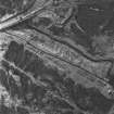
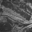
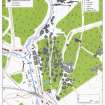
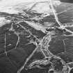
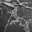
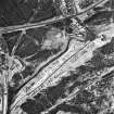
The core of the Wilsontown Ironworks was located on the level floor of the valley of the Mouse Water, in an area about 200m in length from N to S by about 50m in breadth. Donnachie and Butt (1967) describe the main components of the works: 'there were two blast furnaces, the first built in 1779, and the second ... in 1787. In the 1790's an extensive forge was added, and after 1804 a rolling mill for making bar, plate and hoop iron was built at a cost of £14000. There were ten 'fineries' for the production of blooms, kilns for calcining iron and limestone, coke ovens, a foundry with air furnaces and cupolas. Extensive wagon-ways ran along a high causeway which circumnavigated the furnaces and connected the works with the limestone, ironstone and coal workings. There was a lime kiln, a brick-mill, banks of coke, coal and ironstone, a wright's shop, engine houses for several blowing engines. Over the stream a massive culvert was erected, and upon this stood the counting house and the weigh-house. The stream's flow was controlled by two weirs from which pipes led to the cooling area and to the great water cistern which held the reserves for the steam boilers.'
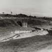
The culvert over the Mouse Water was destroyed in the 1960's (although the abutments remain) along with the triple-arched bridge which crossed over it from one side of the valley to the other (see photographs in NMRS: C/44845 and C/44857; presumably this was the 'high causeway' noted above), and the coke kilns, limekilns and the water cistern, all of which are located above the valley floor, are described separately (11.02, 11.03 and 11.11). The remaining features comprise a number of building foundations, now mostly grassed over. At the centre of the site are the ruins of the two buildings identified as blast furnaces by Donnachie and Butt (1965), approximately opposite each other on either side of the valley. The facades of these buildings survived until the 1960's but the remains are now largely obscured by rubble. That to the W (CSW 7026, NS 9503 5496) measures 8.1m E-W by 6.8m transversely over walls of dressed masonry 0.95m thick, which stand at most two courses (0.7m) high above the rubble. It is set into a steep slope on the W, immediately above a large rectangular tank, perhaps a settling tank, into which much of the demolished masonry has fallen. The interior has two levels, the W half being the higher. Photographs taken before demolition show the E facade with a large arched entrance, a circular window above and an arched light above that (NMRS C/44853-4, C/44857). On the E side of the valley, at NS 9508 5496, the remains of the other furnace (CSW 7028) are less clearly defined, but photographs show a two-storeyed building with an arched entrance in the E wall and two arched windows above (NMRS C/44849, C/44851, C/44854-5). As with the building opposite, there is a rectangular tank immediately in front.
To the S of the W furnace there are traces of a building measuring 10.5m E-W by 9.2m over dressed masonry walls 1m thick. Like the furnaces this building has been built into the side of the valley, and above it there are traces of revetment walling in the hillside, which may have supported a loading platform (CSW 7027, NS 9503 5494).
The forge stood on the E bank of the Mouse, about 100m NNW of the E furnace at NS 9505 5506 (CSW 1028). An undated photograph shows a large gable-ended building (NMRS C/44845) but the walls, constructed of mortared dressed stone, are now no more than 0.5m high. It measures 25.5m in length from N to S by 7.9m in breadth overall. There is a raised platform at the S end and there appears to have been a large hollow in the N half. On the opposite bank of the burn there is another rectangular building, similar in size to the forge (CSW 7033, NS 9502 5505). It measures 19.6m N-S by 8.2m over grassed-over walls of mortared, dressed stone measuring 0.9m in thickness and 0.5m in height. There are possible entrances in the N end and in the E side, there may have been a partition towards the S end, and as with the forge the interior is hollowed. There is also an outshot at the S end. Fragmentary traces of two other buildings are visible on the E side of the valley. One is no more than a vague platform about 25m to the N of the blast furnace, the other, located at the S end of the works, has been extensively robbed but it appears to have measured about 50m in length (CSW 7029, NS 9509 5488).
Apart from the buildings described, there are several hollows and grassed-over mounds on the valley floor, but these cannot be resolved into recognisable structures, with the exception of a deep hollow which appears to be the top of a shaft about 10m SE of the forge at NS 9506 5504.
All the buildings recorded, except the platform to the N of the E blast furnace, can be identified on an map of the Wilsontown Estate (c.1826, National Library of Scotland, Map Library, ref no. EMS.P.166)); the map also shows additional buildings at the core of the works which are no longer visible. The recorded buildings also appear on the 1st edition of the OS 25-inch map (Lanarkshire 1864, sheet xx.2), although the depiction of the structures around the furnaces is somewhat generalised. By that time only the forge was still roofed.
(CSW 1028, 7026-9, 7033)
Visited by RCAHMS (SDB) October 1994, March 1996
Ground Survey (2 July 2007 - 5 July 2007)
NS 9503 5495 An archaeological walkover survey was undertaken at Wilsontown Ironworks on 2–3 and 5 July.
Eleven features were recorded: an outside toilet, two limekilns, a mineshaft, a powder house, two washhouses, a hearth/icehouse and three bell pits.
Report deposited with WoSAS SMR and archive with RCAHMS.
Funder: Forestry Commission Scotland.
Lidar Survey (2010)
NS 950 549
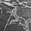
Wilsontown Ironworks were founded in 1779 on the banks of the Mouse Water. Wilsontown was the second of the lowland coke-fired ironworks to be built (after Carron Ironworks in 1759). The works developed over the following three decades and a sizeable community rapidly grew around it, housing nearly 2000 residents by 1812, when the company employed 521 men. Poor transport links, managerial failures and costly legal disputes between the owners led to the collapse of the company in 1812. William Dixon purchased the business in 1821 and restarted production, but in 1842 the Ironworks were finally closed. The much-ruined remains were demolished in 1974. However, many of the early features of the ironworks remain visible, including the blast furnaces, forge, coke and lime kilns and an extensive area of bell pitting. The site has been extensively planned by RCAHMS (Forts, Farms and Furnaces 1996). In order to support this plan and inform
future conservation management, FCS decided to test the application of LiDAR (Light Detection and Ranging) in sitespecific planning and interpretative use.
Forest Research, an agency of the Forestry Commission, has pioneered the use of LiDAR data in identifying historic environment features in woodlands and forests. LiDAR uses pulses of harmless laser energy beamed down from aircraft
flying at c1000m to effectively scan the landscape. The results can highlight archaeological structures and earthworks and can be displayed as interpretative images (and even animation) alongside historical map evidence and aerial photographs. Flying over Wilsontown Ironworks the present ground surface is resplendent with the remains of countless bell pits resulting from coal extraction and the footings of various foundry buildings and cottages.
Funder: FCS
M Ritchie and P Crow 2010

