
Quothquan Law


Fort (Prehistoric), House Platform(S) (Prehistoric)
Site Name Quothquan Law
Classification Fort (Prehistoric), House Platform(S) (Prehistoric)
Canmore ID 47465
Site Number NS93NE 11
NGR NS 9882 3842
Datum OSGB36 - NGR
Permalink http://canmore.org.uk/site/47465


- Council South Lanarkshire
- Parish Libberton
- Former Region Strathclyde
- Former District Clydesdale
- Former County Lanarkshire
Reference (1957)
This site is noted in the ‘List of monuments discovered during the survey of marginal land (1951-5)’ (RCAHMS 1957, xiv-xviii).
Information from RCAHMS (GFG), 24 October 2012.
Measured Survey (9 August 1965)
RCAHMS surveyed this site by plane-table on 9 August 1965 at a scale of 1mm:1ft. The resultant plan was redrawn in ink in 1974 and published at a reduced size in the County Inventory of Lanarkshire (RCAHMS 1978, Figure 62).
Field Visit (14 February 1968)
NS93NE 11 9882 3842.
(NS 9882 3842) Fort (NR)
OS 25" map, (1972).
Feachem notes the surface traces of at least fourteen timber-framed houses within the annexe, but only seven of these were seen in 1974; they measured between 6.5m and 8.0m across.
(RCAHMS 1978, visited 1974; R W Feachem 1963; Visible on RAF air photographs 106G Scot/UK 83: 3113-4).
When seen in 1968, this fort was generally as described by the RCAHMS.
Surveyed at 1:2500.
Visited by OS(EGC) 14 February 1968.
Field Visit (August 1974)
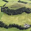
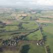
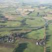
NS988 384. This fort occupies the summit of Quothquan Law (334.7m OD), a conspicuous isolated hill situated 5 km W of Biggar and overlooking a pronounced bend in the River Clyde opposite Thankerton village. To the S and W the flanks of the hill fall sharply to the right bank of the river but in other directions the descent is more gradual. It comprises two elements, an upper (SE) enclosure surrounding the rocky summit knoll, and a lower, possibly later, annexe-like extension to the NW. The upper enclosure measures about 120m by 70m within what has probably been a wall, which has been almost completely denuded; except for short intermittent stretches on the NW, S and SE, where it appears as a slight stony bank, it has been reduced to a mere scarp or crest line. The main entrance is in the NE, where a track leads into the fort, and there is access to the annexe on the SW.
The annexe measures about 100m by 40m and is formed by double ramparts and a medial ditch, but the ramparts are now little more than scarps and the ditch has been almost completely filled in. In addition to the entrance communicating with the fort, there is another entrance in the SW. Within the interior there are at least seven crescentic house platforms measuring between 6.5m and 8.0m across. (See RCAHMS 1978 plan, fig.62).
RCAHMS 1978, visited 1974.
Note (26 August 2014 - 31 August 2016)
This fort is situated on Quothquan Law, a craggy summit that forms a striking topographical feature in its immediate locality. The defences comprise two elements: an upper enclosure which in 1974 RCAHMS investigators saw as the primary fort; with an outer annexe-like enclosure taking in a lower terrace on the NW. On the SW, however, the ramparts of the annexe and the summit enclosure form a continuous scarp, and it is as likely that the two elements simply represent the minimum and maximum extents of the fort in different periods. The upper enclosure on the summit measures 120m from N to S by 70m transversely (0.7ha) within a single rampart reduced largely to a stony scarp, while the outer enclosure extends the interior to about 160m from NW to SE by 100m transversely (1.13ha). The enclosing defences at this end appear more substantial, with an outer concentric rampart and a medial ditch. A trackway climbs obliquely up the slope to an entrance on the SW of this outer enclosure, from which access to the summit would have been gained by following the rampart to the SE, but there is also another entrance into the upper enclosure on the NE. The interior of the upper enclosure is featureless, but at least seven house platforms can be seen in the outer enclosure.
Information from An Atlas of Hillforts of Great Britain and Ireland – 31 August 2016. Atlas of Hillforts SC1704

