
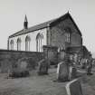
Salsburgh, Hirst Road, Kirk Of Shotts


Burial Ground (Period Unassigned), Church (19th Century), War Memorial (20th Century)
Site Name Salsburgh, Hirst Road, Kirk Of Shotts
Classification Burial Ground (Period Unassigned), Church (19th Century), War Memorial (20th Century)
Alternative Name(s) Kirk Of Shotts And Graveyard; Kirk O' Shotts; War Memorial Plaque
Canmore ID 147605
Site Number NS86SW 65
NGR NS 84276 62950
Datum OSGB36 - NGR
Permalink http://canmore.org.uk/site/147605
Ordnance Survey licence number AC0000807262. All rights reserved.
Canmore Disclaimer.
© Copyright and database right 2024.
- Correction
- Favourite

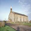
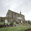
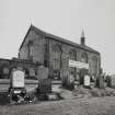
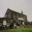
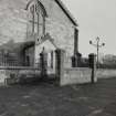
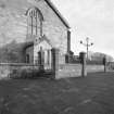
SC 1390254
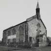
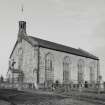
View from South West showing main approach elevations
Records of the Royal Commission on the Ancient and Historical Monuments of Scotland (RCAHMS), Edinbu
15/11/2001
© Crown Copyright: HES

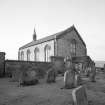
SC 1390255
View from South East from the graveyard
Records of the Royal Commission on the Ancient and Historical Monuments of Scotland (RCAHMS), Edinbu
15/11/2001
© Crown Copyright: HES

SC 1390258
View from graveyard to East showing East gable of church
Records of the Royal Commission on the Ancient and Historical Monuments of Scotland (RCAHMS), Edinbu
15/11/2001
© Crown Copyright: HES

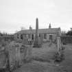
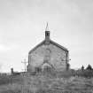
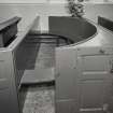
SC 1390261
View of graveyard bothy
Records of the Royal Commission on the Ancient and Historical Monuments of Scotland (RCAHMS), Edinbu
15/11/2001
© Crown Copyright: HES

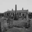
SC 1390262
View of graveyard from West
Records of the Royal Commission on the Ancient and Historical Monuments of Scotland (RCAHMS), Edinbu
15/11/2001
© Crown Copyright: HES

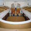
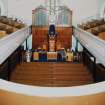
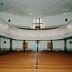
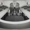
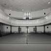
SC 1390265
Interior, view from West from gallery showing the pulpit, organ, pews and raked seating
Records of the Royal Commission on the Ancient and Historical Monuments of Scotland (RCAHMS), Edinbu
15/11/2001
© Crown Copyright: HES

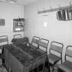
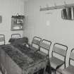
SC 1390267
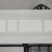
Interior, view of session room showing wood panelling
Records of the Royal Commission on the Ancient and Historical Monuments of Scotland (RCAHMS), Edinbu
15/11/2001
© Crown Copyright: HES

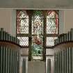
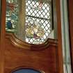
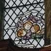
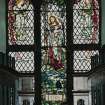
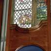
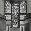
SC 1390270
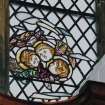
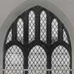
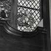
Interior, detail of stained glass East window
Records of the Royal Commission on the Ancient and Historical Monuments of Scotland (RCAHMS), Edinbu
15/11/2001
© Crown Copyright: HES

SC 1390274
Interior, detail of Gallery front
Records of the Royal Commission on the Ancient and Historical Monuments of Scotland (RCAHMS), Edinbu
15/11/2001
© Crown Copyright: HES

SC 2618115
View from North showing main entrance
Records of the Royal Commission on the Ancient and Historical Monuments of Scotland (RCAHMS), Edinbu
15/11/2001
© Crown Copyright: HES

SC 2618116
View from West showing principal gable elevation
Records of the Royal Commission on the Ancient and Historical Monuments of Scotland (RCAHMS), Edinbu
15/11/2001
© Crown Copyright: HES

SC 2618118
View from South West showing main approach elevations
Records of the Royal Commission on the Ancient and Historical Monuments of Scotland (RCAHMS), Edinbu
15/11/2001
© Crown Copyright: HES

SC 2618128
View from graveyard to South East
Records of the Royal Commission on the Ancient and Historical Monuments of Scotland (RCAHMS), Edinbu
15/11/2001
© Crown Copyright: HES

SC 2618146
Interior, detail of stained glass East window
Records of the Royal Commission on the Ancient and Historical Monuments of Scotland (RCAHMS), Edinbu
15/11/2001
© Crown Copyright: HES

SC 2618150
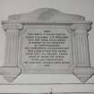
Interior, detail of Walker Monument
Records of the Royal Commission on the Ancient and Historical Monuments of Scotland (RCAHMS), Edinbu
15/11/2001
© Crown Copyright: HES

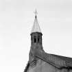
SC 2618154
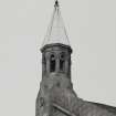
Detail bellcote
Records of the Royal Commission on the Ancient and Historical Monuments of Scotland (RCAHMS), Edinbu
15/11/2001
© Crown Copyright: HES

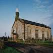
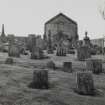
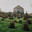
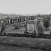
SC 1390257
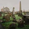
View from North East showing setting in terraced graveyard
Records of the Royal Commission on the Ancient and Historical Monuments of Scotland (RCAHMS), Edinbu
15/11/2001
© Crown Copyright: HES

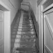
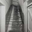
SC 1390266
Interior, view of stairs to gallery from lobby
Records of the Royal Commission on the Ancient and Historical Monuments of Scotland (RCAHMS), Edinbu
15/11/2001
© Crown Copyright: HES

SC 1390276
Interior, detail of Walker Monument
Records of the Royal Commission on the Ancient and Historical Monuments of Scotland (RCAHMS), Edinbu
15/11/2001
© Crown Copyright: HES

SC 1390280
Detail bellcote
Records of the Royal Commission on the Ancient and Historical Monuments of Scotland (RCAHMS), Edinbu
15/11/2001
© Crown Copyright: HES

SC 2618127
View from graveyard to South East
Records of the Royal Commission on the Ancient and Historical Monuments of Scotland (RCAHMS), Edinbu
15/11/2001
© Crown Copyright: HES

SC 2618143
Interior, detail of stained glass East window
Records of the Royal Commission on the Ancient and Historical Monuments of Scotland (RCAHMS), Edinbu
15/11/2001
© Crown Copyright: HES

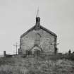
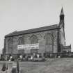
SC 1390253
View from West showing principal gable elevation
Records of the Royal Commission on the Ancient and Historical Monuments of Scotland (RCAHMS), Edinbu
15/11/2001
© Crown Copyright: HES

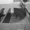
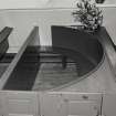
SC 1390269
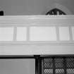
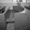
Interior, detail of semicircular box pew
Records of the Royal Commission on the Ancient and Historical Monuments of Scotland (RCAHMS), Edinbu
15/11/2001
© Crown Copyright: HES

SC 1390278
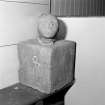
Interior, detail of sundial
Records of the Royal Commission on the Ancient and Historical Monuments of Scotland (RCAHMS), Edinbu
15/11/2001
© Crown Copyright: HES

SC 1390279
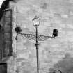
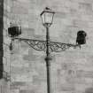
Detail of exterior lamp
Records of the Royal Commission on the Ancient and Historical Monuments of Scotland (RCAHMS), Edinbu
15/11/2001
© Crown Copyright: HES

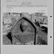
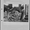
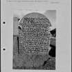
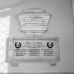
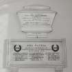
SC 2222333
Photographs and research notes relating to graveyard monuments in Kirk O'Shotts Churchyard, Lanarkshire.
Papers of Betty Willsher, historian, St Andrews, Scotland
© HES (Betty Willsher Collection)

SC 2618117
View from South West showing main approach elevations
Records of the Royal Commission on the Ancient and Historical Monuments of Scotland (RCAHMS), Edinbu
15/11/2001
© Crown Copyright: HES

SC 2618121
View from North East showing setting in terraced graveyard
Records of the Royal Commission on the Ancient and Historical Monuments of Scotland (RCAHMS), Edinbu
15/11/2001
© Crown Copyright: HES

SC 2618136
Interior, view from West from gallery showing the pulpit, organ, pews and raked seating
Records of the Royal Commission on the Ancient and Historical Monuments of Scotland (RCAHMS), Edinbu
15/11/2001
© Crown Copyright: HES

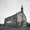
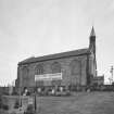
SC 1390252
View from North showing main entrance
Records of the Royal Commission on the Ancient and Historical Monuments of Scotland (RCAHMS), Edinbu
15/11/2001
© Crown Copyright: HES

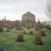
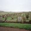
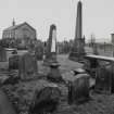
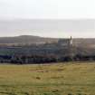
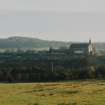
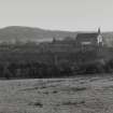
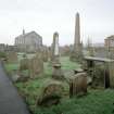
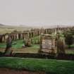
SC 1390259
Distant view from North the church and the extensive graveyard
Records of the Royal Commission on the Ancient and Historical Monuments of Scotland (RCAHMS), Edinbu
15/11/2001
© Crown Copyright: HES

SC 1390268
Interior, detail of semicircular box pew
Records of the Royal Commission on the Ancient and Historical Monuments of Scotland (RCAHMS), Edinbu
15/11/2001
© Crown Copyright: HES

SC 1390272
Interior, detail of stained glass East window
Records of the Royal Commission on the Ancient and Historical Monuments of Scotland (RCAHMS), Edinbu
15/11/2001
© Crown Copyright: HES

SC 2222332
Photographs and research notes relating to graveyard monuments in Kirk O'Shotts Churchyard, Lanarkshire.
Papers of Betty Willsher, historian, St Andrews, Scotland
© HES (Betty Willsher Collection)

SC 2618119
View from South East from the graveyard
Records of the Royal Commission on the Ancient and Historical Monuments of Scotland (RCAHMS), Edinbu
15/11/2001
© Crown Copyright: HES

SC 2618122
View from North East showing setting in terraced graveyard
Records of the Royal Commission on the Ancient and Historical Monuments of Scotland (RCAHMS), Edinbu
15/11/2001
© Crown Copyright: HES

SC 2618123
View from graveyard to East showing East gable of church
Records of the Royal Commission on the Ancient and Historical Monuments of Scotland (RCAHMS), Edinbu
15/11/2001
© Crown Copyright: HES

SC 2618138
Interior, view of session room showing wood panelling
Records of the Royal Commission on the Ancient and Historical Monuments of Scotland (RCAHMS), Edinbu
15/11/2001
© Crown Copyright: HES

SC 2618144
Interior, detail of stained glass East window
Records of the Royal Commission on the Ancient and Historical Monuments of Scotland (RCAHMS), Edinbu
15/11/2001
© Crown Copyright: HES

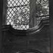
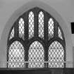
SC 2618147
Interior, detail of window tracery
Records of the Royal Commission on the Ancient and Historical Monuments of Scotland (RCAHMS), Edinbu
15/11/2001
© Crown Copyright: HES

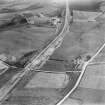
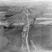
SC 1256949
The A8 Glasgow and Edinburgh Road, Kirk of Shotts, Shotts. Oblique aerial photograph taken facing east.
Records of Aerofilms Ltd, aerial photographers, Bristol, England
8/1930
© HES (Aerofilms Collection)

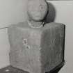
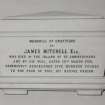
SC 1390277
Interior, detail of Mitchel Monument
Records of the Royal Commission on the Ancient and Historical Monuments of Scotland (RCAHMS), Edinbu
15/11/2001
© Crown Copyright: HES

SC 2222334
Photographs and research notes relating to graveyard monuments in Kirk O'Shotts Churchyard, Lanarkshire.
Papers of Betty Willsher, historian, St Andrews, Scotland
© HES (Betty Willsher Collection)

SC 2233764
View from SW showing WSW and SSE fronts of Kirk of Shotts, Hirst Road, Salsburgh.
Papers of Professor John R Hume, economic and industrial historian, Glasgow, Scotland
1979
© HES. Reproduced courtesy of J R Hume

SC 2618126
Distant view from North the church and the extensive graveyard
Records of the Royal Commission on the Ancient and Historical Monuments of Scotland (RCAHMS), Edinbu
15/11/2001
© Crown Copyright: HES

SC 2618134
Interior, view from East showing horseshoe gallery
Records of the Royal Commission on the Ancient and Historical Monuments of Scotland (RCAHMS), Edinbu
15/11/2001
© Crown Copyright: HES

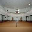
SC 1390264
Interior, view from East showing horseshoe gallery
Records of the Royal Commission on the Ancient and Historical Monuments of Scotland (RCAHMS), Edinbu
15/11/2001
© Crown Copyright: HES

SC 2618120
View from North North West showing the appeal banner
Records of the Royal Commission on the Ancient and Historical Monuments of Scotland (RCAHMS), Edinbu
15/11/2001
© Crown Copyright: HES

SC 2618132
Detail of entrance porch, railings and steps
Records of the Royal Commission on the Ancient and Historical Monuments of Scotland (RCAHMS), Edinbu
15/11/2001
© Crown Copyright: HES

SC 2618135
Interior, view from West from gallery showing the pulpit, organ, pews and raked seating
Records of the Royal Commission on the Ancient and Historical Monuments of Scotland (RCAHMS), Edinbu
15/11/2001
© Crown Copyright: HES

SC 2618137
Interior, view of stairs to gallery from lobby
Records of the Royal Commission on the Ancient and Historical Monuments of Scotland (RCAHMS), Edinbu
15/11/2001
© Crown Copyright: HES

SC 2618142
Interior, detail of stained glass East window
Records of the Royal Commission on the Ancient and Historical Monuments of Scotland (RCAHMS), Edinbu
15/11/2001
© Crown Copyright: HES

SC 2618153
Detail of exterior lamp
Records of the Royal Commission on the Ancient and Historical Monuments of Scotland (RCAHMS), Edinbu
15/11/2001
© Crown Copyright: HES

SC 1256935
The A8 Glasgow and Edinburgh Road, Salsburgh, Shotts. Oblique aerial photograph taken facing west.
Records of Aerofilms Ltd, aerial photographers, Bristol, England
8/1930
© HES (Aerofilms Collection)

SC 1390263
Detail of entrance porch, railings and steps
Records of the Royal Commission on the Ancient and Historical Monuments of Scotland (RCAHMS), Edinbu
15/11/2001
© Crown Copyright: HES

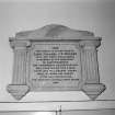
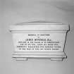
SC 1390275
Interior, detail of War Memorial and Hamilton of Murieston Monument
Records of the Royal Commission on the Ancient and Historical Monuments of Scotland (RCAHMS), Edinbu
15/11/2001
© Crown Copyright: HES

SC 2618125
Distant view from North the church and the extensive graveyard
Records of the Royal Commission on the Ancient and Historical Monuments of Scotland (RCAHMS), Edinbu
15/11/2001
© Crown Copyright: HES

SC 2618129
View of graveyard bothy
Records of the Royal Commission on the Ancient and Historical Monuments of Scotland (RCAHMS), Edinbu
15/11/2001
© Crown Copyright: HES

SC 2618133
Interior, view from East showing horseshoe gallery
Records of the Royal Commission on the Ancient and Historical Monuments of Scotland (RCAHMS), Edinbu
15/11/2001
© Crown Copyright: HES

SC 2618140
Interior, detail of semicircular box pew
Records of the Royal Commission on the Ancient and Historical Monuments of Scotland (RCAHMS), Edinbu
15/11/2001
© Crown Copyright: HES

SC 2618148
Interior, detail of Gallery front
Records of the Royal Commission on the Ancient and Historical Monuments of Scotland (RCAHMS), Edinbu
15/11/2001
© Crown Copyright: HES

SC 2618149
Interior, detail of War Memorial and Hamilton of Murieston Monument
Records of the Royal Commission on the Ancient and Historical Monuments of Scotland (RCAHMS), Edinbu
15/11/2001
© Crown Copyright: HES

SC 2618152
Interior, detail of sundial
Records of the Royal Commission on the Ancient and Historical Monuments of Scotland (RCAHMS), Edinbu
15/11/2001
© Crown Copyright: HES

SC 1390256
View from North North West showing the appeal banner
Records of the Royal Commission on the Ancient and Historical Monuments of Scotland (RCAHMS), Edinbu
15/11/2001
© Crown Copyright: HES

SC 1390260
View from graveyard to South East
Records of the Royal Commission on the Ancient and Historical Monuments of Scotland (RCAHMS), Edinbu
15/11/2001
© Crown Copyright: HES

SC 1390271
Interior, detail of stained glass East window
Records of the Royal Commission on the Ancient and Historical Monuments of Scotland (RCAHMS), Edinbu
15/11/2001
© Crown Copyright: HES

SC 1390273
Interior, detail of window tracery
Records of the Royal Commission on the Ancient and Historical Monuments of Scotland (RCAHMS), Edinbu
15/11/2001
© Crown Copyright: HES

SC 2618124
View from graveyard to East showing East gable of church
Records of the Royal Commission on the Ancient and Historical Monuments of Scotland (RCAHMS), Edinbu
15/11/2001
© Crown Copyright: HES

SC 2618130
View of graveyard from West
Records of the Royal Commission on the Ancient and Historical Monuments of Scotland (RCAHMS), Edinbu
15/11/2001
© Crown Copyright: HES

SC 2618131
View of graveyard from West
Records of the Royal Commission on the Ancient and Historical Monuments of Scotland (RCAHMS), Edinbu
15/11/2001
© Crown Copyright: HES

SC 2618139
Interior, detail of semicircular box pew
Records of the Royal Commission on the Ancient and Historical Monuments of Scotland (RCAHMS), Edinbu
15/11/2001
© Crown Copyright: HES

SC 2618141
Interior, detail of stained glass East window
Records of the Royal Commission on the Ancient and Historical Monuments of Scotland (RCAHMS), Edinbu
15/11/2001
© Crown Copyright: HES

SC 2618145
Interior, detail of stained glass East window
Records of the Royal Commission on the Ancient and Historical Monuments of Scotland (RCAHMS), Edinbu
15/11/2001
© Crown Copyright: HES

SC 2618151
Interior, detail of Mitchel Monument
Records of the Royal Commission on the Ancient and Historical Monuments of Scotland (RCAHMS), Edinbu
15/11/2001
© Crown Copyright: HES

- Council North Lanarkshire
- Parish Shotts (Monklands)
- Former Region Strathclyde
- Former District Monklands
- Former County Lanarkshire
ARCHITECT: John Brash 1820 (Modification of design by Gillespie Graham).

