
St Thomas's Well


Burial Ground (Period Unassigned), Chapel (Period Unassigned), Well (Period Unassigned)
Site Name St Thomas's Well
Classification Burial Ground (Period Unassigned), Chapel (Period Unassigned), Well (Period Unassigned)
Canmore ID 46237
Site Number NS79SE 52
NGR NS 77884 93056
Datum OSGB36 - NGR
Permalink http://canmore.org.uk/site/46237


- Council Stirling
- Parish Stirling
- Former Region Central
- Former District Stirling
- Former County Stirlingshire
NS79SE 52.00 77884 93056
(NS 7788 9305) W. [NAT]
OS 25" map (1917).
NS79SE 52.01 NS 77895 93084 Farmsteading
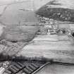
There is a perfectly circular pond, nearly 100ft in circumference, in the centre of the steading of St Thomas's Farm. Water rises from a spring in the centre, and it would appear that steps once led down the embankment to the water. Scattered round the yard and built into the walls of the buildings are about thirty carved pieces of stone, including a hog-backed grave stone. Three of the stones bore mason's marks. An authority on early architecture (J Honeyman, Glasgow) stated that the stones came from a large church, 12th century or possibly earlier but not the first church on the site.
No trace of the foundations was found, with the exception of what appeared to be the remains of a common dyke at the NW corner of the embankment. The well may have been originally of more moderate dimensions, subsequently enlarged into a pond for farm use.
All the circumstances suggest that this was the site of the chapel where Robert the Bruce took the sacrament before Bannockburn and of the holy well known as 'Christ's Well', not the alleged sites in Cambusbarron (NS79SE 8).
J S Fleming 1898.
St Thomas's Well has been restored and incorporated in a landscape garden. It shows no indications of any antiquity. The pond in the centre of the steading is as described by Fleming and lies at NS 7790 9304. There is no sign of the steps mentioned: it appears to be simply a farm pond. Several of the carved stones are still to be seen but although some of the buildings are of considerable age, there are no certain indications of the former presence of a chapel.
Revised at 25".
Visited by OS (WDJ), 29 May 1969.

