
Myot Hill


Fort (Iron Age)
Site Name Myot Hill
Classification Fort (Iron Age)
Canmore ID 45957
Site Number NS78SE 1
NGR NS 78092 82497
Datum OSGB36 - NGR
Permalink http://canmore.org.uk/site/45957


- Council Falkirk
- Parish Denny
- Former Region Central
- Former District Falkirk
- Former County Stirlingshire
Field Visit (7 May 1953)
NS 78 SE 781 825 (unnoted)
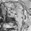
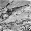
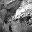
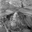
Fort, Myot Hill.
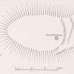
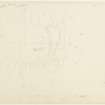
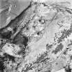
This fort is situated on the summit of Myot Hill, which rises abruptly to a height of 696 ft. above sea-level from the plain to the E. of Denny Muir. It commands wide views in all directions, including a stretch of the Antonine Wall from Bar Hill on the SW. to beyond Rough Castle on the SE. The hill falls sharply away from the summit area to N., W. and S., but to the E. a gentle slope runs evenly down to the plain. The fort (Fig. 14), which has been almost obliterated by stone-robbing and weathering, is oval on plan and measures 215 ft. in length from E. to W. by 140 ft. transversely. No traces of defences can be seen along the crests of the steep slopes to N., W. and S., but the slope to the E. is traversed by the mutilated remains of two ramparts. The inner one, a low, slightly curved mound spread to a maximum width of 13 ft., runs S. from the crest of the N. slope for a distance of 105 ft. After being broken by a gap 1 I ft. wide, which must represent the site of the original entrance, it resumes to continue in the form of a low scarp for some 25 ft. before merging into the crest of the S. slope of the hill. The outer rampart, which is only represented by a low scarp, takes a similar course to the inner one, running from a point on the N. crest of the hill at a distance 38 ft. E. of the beginning of the latter to finish 28 ft. E. of the N. side of the entrance-gap. After a break of 22 ft. It resumes in the form of a slight terrace, which runs SW. and W. for a distance of 42 ft. before fading away on the S. slopes of the hill. Apart from a small modern building, the interior is featureless.
The possible connection of the place-name Myot Hill with the tribal name Maeatae is noted by Watson (Placenames, 59).
RCAHMS 1963, visited 7 May 1953.
Reference (1957)
This site is noted in the ‘List of monuments discovered during the survey of marginal land (1951-5)’ (RCAHMS 1957, xiv-xviii).
Information from RCAHMS (GFG), 24 October 2012.
Field Visit (July 1977)
Myot Hill NS 780 825 NS78SE 1
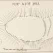
Oval fort, measuring about 65m from W to E and 42m transversely, with two ramparts showing faintly on the E side of the hilltop only. Since the site was visited in 1953, the brick building shown on the inventory plan has been demolished and has been replaced by a new aerial mast and associated building sited between the inner and outer ramparts just N of the entrance.
RCAHMS 1978, visited July 1977
(RCAHMS 1963, p.75, No. 75; Feachem 1963, 157-8)
Note (14 August 2014 - 16 November 2016)
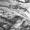
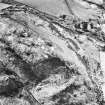
The scant remains of a fort are situated on Myot Hill a steep-sided summit W of Denny that is now crowned by telecommunication masts. There are no more than traces of defences around the N, W and S margins of the hill, but on the E two heavily robbed ramparts can be seen, creating an enclosure measuring about 65m from E to W by 42m transversely (0.18ha) on the summit. The entrance is probably on the ESE.
Information from An Atlas of Hillforts of Great Britain and Ireland – 16 November 2016. Atlas of Hillforts SC1492
Field Visit ( - 1974)
NS78SE 1 7808 8250.
(NS 7808 8250) Fort (NR)
OS 25" map (1964)
A fort generally as described by RCAHMS.
Surveyed at 1:2500.
Visited by OS (AC) 2 July 1959 and (JP) 22 January 1974

