
Mollins


Roman Fort (Roman)
Site Name Mollins
Classification Roman Fort (Roman)
Canmore ID 45931
Site Number NS77SW 6
NGR NS 71382 71892
NGR Description Centre
Datum OSGB36 - NGR
Permalink http://canmore.org.uk/site/45931


- Council East Dunbartonshire
- Parish Cadder (Strathkelvin-du)
- Former Region Strathclyde
- Former District Strathkelvin
- Former County Lanarkshire
NS77SW 6 7139 7189
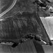
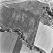
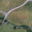
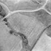
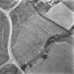
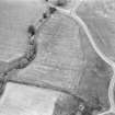
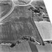
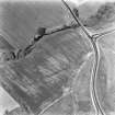
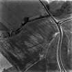
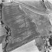
NS 713 718. Roman Fort (Site), Mollins: This fort occupies the W end of a low ridge immediately NE of Mollins farmhouse, some 4 km S of the Antonine Wall.
First identified from cropmarks, it measures about 64m by 58m over the rampart (0.4 ha); an annexe, roughly half the size of the main enclosure, protected by a single ditch, adjoins the fort on the W. Excavation (W S Hanson and G S Maxwell 1980) indicated that the site was probably built and deliberately destroyed during the later 1st century AD; it may thus have formed part of the chain of praesidia drawn across the isthmus by the governor Julius Agricola.
RCAHMS 1978; 1982; The Scotsman, 10 November 1978
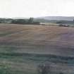
Field under crop when visited; no surface indications.
Visited by OS (MJF) 20 June 1980
Note (1982)
Mollins, Fort NS 713 718 NS77SW 6
This fort occupies the W end of a low ridge immediately NE of Mollins farmhouse, some 4km S of the Antonine Wall. First identified from cropmarkings, it measures about 64m by 58m over the rampart (0.4ha); an annexe, roughly half the size of the main enclosure, adjoins the fort on the W. Excavation indicated that the site was probably built and deliberately demolished during the later 1st century AD; it may thus have formed part of the chain of praesidia drawn across the isthmus by the governor Julius Agricola.
RCAHMS 1982
(RCAHMS 1978, p. 160, No. 336; Hanson and Maxwell 1980)
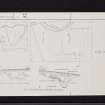
Resistivity (April 1994 - June 1994)
A geophysical survey confirmed the alignment of the inner ditch, already plotted by aerial survey and subsequent excavation (W S Hanson and G S Maxwell 1980), with an apparent entrance gap on the N side. Other features included a ditch running S from the SW corner of the fort.
L J F Keppie 1995.
Area A. Resistivity survey for 94/48 M80 motorway extension. Part of a wider evaluation, 1994.
Archaeological Evaluation (19 March 2007 - 15 June 2007)
NS 657 693 to NS 793 798 A programme of archaeological works was undertaken between 19 March–15 June 2007 in advance of the M80 improvement. The route for the new section of the motorway runs from Stepps in North Lanarkshire to Haggs in the Falkirk area and incorporates the route of the existing A80, which currently links the two stretches of the existing M80.
The fieldwork consisted of a trial trench evaluation of the road corridor, a watching brief on geotechnical test holes, building recording, surveys and a palaeoenvironmental assessment of five sites. The evaluation was designed as 10% of the 1,584,200m² development area. A large proportion of this area could not be trenched because of constraints such as services, tree cover and peat basins. A total of 842 trenches (91,186m²) were
excavated in differing landscape settings from rolling hillsides to parkland and motorway verges. M any features were recorded in the trenches that are representative of cultivation and field improvement. These took the form of rig and furrow and frequent rubble and ceramic field drains. A number of features indicative of localised fires were also recovered. The evaluation along with the palaeoenvironmental assessment revealed a
landscape where peat deposits have accumulated in glacially scoured hollows, suggesting that these low-lying areas were very wet and boggy and unsuitable for settlement. Cultivation of drier pockets of land has taken place from the medieval period onwards. The only evidence of prehistoric or Roman activity anywhere along the line evaluated consisted of the find of a stone quern in a trench adjacent to Mollins Roman fort (NS77SW 6).
Archive to be deposited with RCAHMS. Report to be deposited with WoSAS and RCAHMS.
Funder: Historic Scotland for Transport Scotland
Sarah-Jane Haston - Headland Archaeology Ltd
OASIS ID headland1-97065
Watching Brief (13 February 2009 - 24 March 2011)
NS 657 693 to NS 793 798 A watching brief was undertaken 13 February – 24 March 2011 during construction work associated with the M80 motorway improvement scheme. Few archaeological features were recorded, and the results were comparable to those of the evaluation carried out by Headland in 2007.
Monitoring of areas immediately adjacent to the M80 revealed that there had been significant landscaping during road construction in the 1960s, which probably removed much of the archaeology at these locations. No features were recorded in the areas where peat had developed. At other locations more suitable for habitation, such as on higher and better draining ground, some evidence for agricultural activity dating from the medieval period onwards was recorded.
Archive: RCAHMS (intended). Report: WoSAS (intended)
Funder: Historic Scotland on behalf of Transport Scotland
Alistair Robertson, Headland Archaeology Ltd 2012. OASIS ID: headland1-101979
Watching Brief (13 February 2009 - 24 March 2011)
[NS 71350 71970] Topsoil stripping adjacent to the scheduled area at Mollins Roman Fort was monitored with additional metal detecting undertaken due to its proximity to the scheduled area of Mollins Roman Fort. The natural subsoil consisted of mottled yellow and grey clays interspersed with mid brown sandy clay. Overlying this was mid brown loam containing abundant
coal and clinker fragments 0.2m deep. A clay pipe stem of 17th/18th century was recovered from this deposit as well as various sherds of medieval to post medieval ceramics Metal detection revealed part of a small lead pistol ball of post medieval/ modern origin.
Several miscellaneous metal objects were recovered from the topsoil including a coin likely to be a 19th century halfpenny. No archaeological features were identified.
Alistair Robertson, Headland Archaeology Ltd 2012. OASIS ID: headland1-101979
Note (17 November 2022)
The location, classification and period of this site have been reviewed and changed from ROMAN FORT (ROMAN), QUERN (PERIOD UNASSIGNED).

