
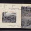
Castlecary


Roman Fort (Roman)
Site Name Castlecary
Classification Roman Fort (Roman)
Alternative Name(s) Castle Cary
Canmore ID 45828
Site Number NS77NE 24
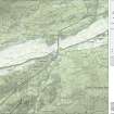
NGR NS 78973 78259
Datum OSGB36 - NGR
Permalink http://canmore.org.uk/site/45828


- Council Falkirk
- Parish Falkirk
- Former Region Central
- Former District Falkirk
- Former County Stirlingshire
NS77NE 24.00 78973 78259
(NS 790 783) Castlecary (NAT)
Roman Fort (R) (remains of)
OS 1:10,000 map, (1976).
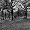
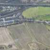
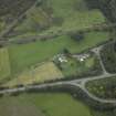
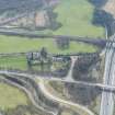
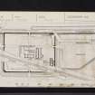
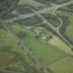
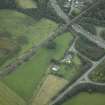
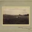
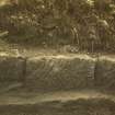
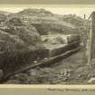
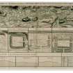
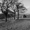
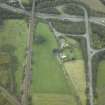
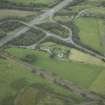
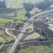
The Roman fort at Castlecary occupies a rounded knoll at the W end of a low ridge, and is protected by the valley of the Bonny Water on the N, the ravine of the Red Burn on the W, also by a tract of low-lying land, which was formerly marshy, along nearly the whole of the S front. Periodically raided for building materials from at least as early as the 15th century, the fort was mutilated in 1841 when the line of the Edinburgh and Glasgow railway was carried diagonally across it, and further damage was no doubt done when the modern road was laid along the N front. At the present time the portion of the site that lies to the N of the railway is in permanent pasture, while the portion S of the railway is cultivated.
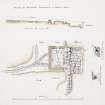
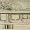
Excavations in 1902 (D Christison 1903), showed that the fort was oblong on plan and enclosed an area of 3 1/2 acres, the internal dimensions being 455ft from N to S by 350ft transversely.
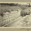
The main defence consisted of a stone wall which was carried round all four sides of the fort, the Rampart of the Antonine Wall abutting the NW and NE corners. The fort wall was built of stones quarried from the outcrop of rock immediately to the W of the site: it was 6ft 6ins
thick and was set on a massive foundation-course which in turn rested on a bottoming of clay and cobbles. The N wall, however, differed from the others in that it was thickened at either end to bring it more nearly into conformity with the thickness of the Antonine Rampart, while it may have had a rampart bank against the inner face.
The Ditch of the Antonine Wall formed the outer defence of the fort on the N side, although to the W of the causeway opposite the N gate it was reduced to about half its normal width. The other three sides each had two ditches, both 14ft wide and 7ft deep, except for about half the length of the E side where there were three. The four gates were of uniform design, and their arrangement shows that the fort faced N: each had only a single passageway, for a distance of 7ft 6ins on either side of the entrance. An internal tower, 15ft square, was found at the SW corner, and it may be assumed that a similar tower was provided at the SE corner.
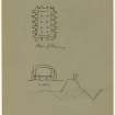
The lay-out of the fort was only partially recovered; the headquarters building, a granary, the commandant's house and the internal bath-house, the latter discovered in 1769 and planned by Roy, (W Roy 1793), were located. The excavations also revealed a latrine in the NE corner of the fort, a rubbish-pit, and part of the internal drainage system, but nothing was learned about the number, or method of construction, of the barracks.
One of the most important results of the excavations of 1902 was the discovery of a fortified annexe on the E side of the fort. Covering an area of 2 3/4 acres and defended on the exposed sides by a rampart of earth or turf and a ditch, it had a gate in the E side and was traversed by the Military Way which ran parallel to the via principalis of the fort but slightly to the N of it.
The majority of the relics from the excavations of 1902 were deposited in the NMAS, which also houses a few earlier finds, including a number of inscribed and sculptured stones. Three more inscribed stones and a number of other relics from the site are in the Hunterian Museum, Glasgow. Although the great majority of the relics are Antonine in date, there is a sufficient number of 1st century sherds, including not only Samian and coarse wares, but also examples of the so-called 'Belgic' ware, to make it quite certain that Castlecary was the site of one of the praesidia established by Agricola between the Forth and Clyde in AD 80 or 81. But the excavations gave no clue as to the precise location or nature of this early fort.
RCAHMS 1963; J Stuart 1856.
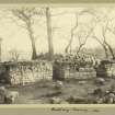
Only the line of the E rampart of the fort can be seen as a swelling in the ground, some 5.0m broad and 0.7m high, in the area N of the railway line. A fragment of the E kerb of the rampart wall is exposed here on either side of where the entrance would lie.
In this same area, the outlines of the principia and granary are seen in a small plantation. Of the two, the granary is the better defined, measuring 26 by 5.0m while the turf-covered walls are 1.0m wide and 0.5m high. There are no traces of any other buildings within the area of the fort.
Except for a slight suggestion of the two ditches in pasture on the E side, no other features of the fort were found. A few dressed stones lie within the area of the buildings.
On the S-facing slope S of the railway is an undulating pasture field with a very slight scarp noticeable at the SW angle of the fort. There is no trace of the annexe.
Visited by OS(JLD) 23 January 1957.
As described above.
Resurveyed at 1:2500.
Visited by OS(RD) 10 April 1967.
NS 790 783 and NS 790 784. Casual finds in 1974 and 1976 include much pottery and flue tile, and several fragments of glass.
E J Price 1974; DES (Small finds) 1976.
Part of a white glass armlet found S of the fort is in the National Museum of Antiquities of Scotland (NMAS).
NMAS Annual Report 1977-8.
The area of the fort is regularly under plough; however, the fragment of rampart base near the NE angle and the outline of the granary and principia, in the plantation, can still be seen.
Visited by OS(MJF) 24 May 1980.
Two bun-shaped querns.
E J MacKie 1971.
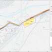
As part of an archaeological assessment on a possible alignment for a motorway extension, a geophysical survey by Geophysical Surveys of Bradford revealed double ditches defending the SW quarter of the fort, double ditches defending its E side and a single annexe ditch to the E, and other features.
L J F Keppie 1995
NS 7900 7830 Electrical (and some magnetic) survey of 3ha to the SE and W of the fort in June 2006 revealed a wide range of anomalies, linear, rectangular and circular in shape. Some of these anomalies may represent features associated with the Roman civilian settlement, others are of later, even recent date. Interpretation of the results continues. Conductivity was used experimentally.
Archive location not yet known.
Sponsor: EU Culture 2000.
Richard Jones, 2006.
Excavation (1902)
The Roman fort at Castlecary occupies a rounded knoll at the W end of a low ridge, and is protected by the valley of the Bonny Water on the N, the ravine of the Red Burn on the W, also by a tract of low-lying land, which was formerly marshy, along nearly the whole of the S front. Periodically raided for building materials from at least as early as the 15th century, the fort was mutilated in 1841 when the line of the Edinburgh and Glasgow railway was carried diagonally across it, and further damage was no doubt done when the modern road was laid along the N front. At the present time the portion of the site that lies to the N of the railway is in permanent pasture, while the portion S of the railway is cultivated.
Excavations in 1902 (D Christison 1903), showed that the fort was oblong on plan and enclosed an area of 3 1/2 acres, the internal dimensions being 455ft from N to S by 350ft transversely.
The main defence consisted of a stone wall which was carried round all four sides of the fort, the Rampart of the Antonine Wall abutting the NW and NE corners. The fort wall was built of stones quarried from the outcrop of rock immediately to the W of the site: it was 6ft 6ins thick and was set on a massive foundation-course which in turn rested on a bottoming of clay and cobbles. The N wall, however, differed from the others in that it was thickened at either end to bring it more nearly into conformity with the thickness of the Antonine Rampart, while it may have had a rampart bank against the inner face.
The Ditch of the Antonine Wall formed the outer defence of the fort on the N side, although to the W of the causeway opposite the N gate it was reduced to about half its normal width. The other three sides each had two ditches, both 14ft wide and 7ft deep, except for about half the length of the E side where there were three. The four gates were of uniform design, and their arrangement shows that the fort faced N: each had only a single passageway, for a distance of 7ft 6ins on either side of the entrance. An internal tower, 15ft square, was found at the SW corner, and it may be assumed that a similar tower was provided at the SE corner.
The lay-out of the fort was only partially recovered; the headquarters building, a granary, the commandant's house and the internal bath-house, the latter discovered in 1769 and planned by Roy, (W Roy 1793), were located. The excavations also revealed a latrine in the NE corner of the fort, a rubbish-pit, and part of the internal drainage system, but nothing was learned about the number, or method of construction, of the barracks.
One of the most important results of the excavations of 1902 was the discovery of a fortified annexe on the E side of the fort. Covering an area of 2 3/4 acres and defended on the exposed sides by a rampart of earth or turf and a ditch, it had a gate in the E side and was traversed by the Military Way which ran parallel to the via principalis of the fort but slightly to the N of it.
The majority of the relics from the excavations of 1902 were deposited in the NMAS, which also houses a few earlier finds, including a number of inscribed and sculptured stones. Three more inscribed stones and a number of other relics from the site are in the Hunterian Museum, Glasgow. Although the great majority of the relics are Antonine in date, there is a sufficient number of 1st century sherds, including not only Samian and coarse wares, but also examples of the so-called 'Belgic' ware, to make it quite certain that Castlecary was the site of one of the praesidia established by Agricola between the Forth and Clyde in AD 80 or 81. But the excavations gave no clue as to the precise location or nature of this early fort.
RCAHMS 1963; J Stuart 1856.
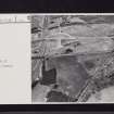
Aerial Photography (6 July 1949)
Aerial Photography (11 July 1951)
Aerial Photography (12 July 1952)
Aerial Photography (1 August 1957)
Field Visit (23 January 1957)
Only the line of the E rampart of the fort can be seen as a swelling in the ground, some 5.0m broad and 0.7m high, in the area N of the railway line. A fragment of the E kerb of the rampart wall is exposed here on either side of where the entrance would lie.
In this same area, the outlines of the principia and granary are seen in a small plantation. Of the two, the granary is the better defined, measuring 26 by 5.0m while the turf-covered walls are 1.0m wide and 0.5m high. There are no traces of any other buildings within the area of the fort.
Except for a slight suggestion of the two ditches in pasture on the E side, no other features of the fort were found. A few dressed stones lie within the area of the buildings.
On the S-facing slope S of the railway is an undulating pasture field with a very slight scarp noticeable at the SW angle of the fort. There is no trace of the annexe.
Visited by OS(JLD) 23 January 1957.
Measured Survey (1958)
Photographic Survey (1961)
Aerial Photography (22 July 1962)
Aerial Photography (27 July 1963)
Aerial Photography (28 July 1966)
Field Visit (10 April 1967)
Same as previous visit.
Resurveyed at 1:2500.
Visited by OS(RD) 10 April 1967.
Measured Survey (10 April 1967)
Same as previous visit.
Resurveyed at 1:2500.
Visited by OS(RD) 10 April 1967.
Aerial Photography (28 July 1967)
Aerial Photography (27 July 1968)
Aerial Photography (1971)
Aerial Photography (26 July 1972)
Artefact Recovery (1974 - 1976)
NS 790 783 and NS 790 784. Casual finds in 1974 and 1976 include much pottery and flue tile, and several fragments of glass.
E J Price 1974; DES (Small finds) 1976.
Part of a white glass armlet found S of the fort is in the National Museum of Antiquities of Scotland (NMAS).
NMAS Annual Report 1977-8.
Note (1978)
Castlecary, NS 790 783 NS77NE 24
Listed as fort.
RCAHMS 1978
(Christison and Buchanan 1903; Macdonald 1934, 241-52; RCAHMS 1963, pp. 103-6, No. 117)
Aerial Photography (30 July 1979)
Field Visit (24 May 1980)
The area of the fort is regularly under plough; however, the fragment of rampart base near the NE angle and the outline of the granary and principia, in the plantation, can still be seen.
Visited by OS(MJF) 24 May 1980.
Aerial Photography (24 July 1981)
Aerial Photography (25 July 1981)
Resistivity (April 1994 - June 1994)
area E
As part of an archaeological assessment on a possible alignment for a motorway extension, a geophysical survey by Geophysical Surveys of Bradford revealed double ditches defending the SW quarter of the fort, double ditches defending its E side and a single annexe ditch to the E, and other features.
L J F Keppie 1995
Resistivity (April 1994 - June 1994)
area D
As part of an archaeological assessment on a possible alignment for a motorway extension, a geophysical survey by Geophysical Surveys of Bradford revealed double ditches defending the SW quarter of the fort, double ditches defending its E side and a single annexe ditch to the E, and other features.
L J F Keppie 1995
Magnetometry (April 1994 - June 1994)
area E
As part of an archaeological assessment on a possible alignment for a motorway extension, a geophysical survey by Geophysical Surveys of Bradford revealed double ditches defending the SW quarter of the fort, double ditches defending its E side and a single annexe ditch to the E, and other features.
L J F Keppie 1995
Magnetometry (April 1994 - June 1994)
area D
As part of an archaeological assessment on a possible alignment for a motorway extension, a geophysical survey by Geophysical Surveys of Bradford revealed double ditches defending the SW quarter of the fort, double ditches defending its E side and a single annexe ditch to the E, and other features.
L J F Keppie 1995
Magnetometry (1994)
area
As part of an archaeological assessment on a possible alignment for a motorway extension, a geophysical survey by Geophysical Surveys of Bradford revealed double ditches defending the SW quarter of the fort, double ditches defending its E side and a single annexe ditch to the E, and other features.
L J F Keppie 1995
Resistivity (5 June 2006 - 23 June 2006)
area a
NS 7900 7830 Electrical (and some magnetic) survey of 3ha to the SE and W of the fort in June 2006 revealed a wide range of anomalies, linear, rectangular and circular in shape. Some of these anomalies may represent features associated with the Roman civilian settlement, others are of later, even recent date. Interpretation of the results continues. Conductivity was used experimentally.
Archive location not yet known.
Sponsor: EU Culture 2000.
Richard Jones, 2006.
Magnetometry (5 June 2006 - 23 June 2006)
area C
NS 7900 7830 Electrical (and some magnetic) survey of 3ha to the SE and W of the fort in June 2006 revealed a wide range of anomalies, linear, rectangular and circular in shape. Some of these anomalies may represent features associated with the Roman civilian settlement, others are of later, even recent date. Interpretation of the results continues. Conductivity was used experimentally.
Archive location not yet known.
Sponsor: EU Culture 2000.
Richard Jones, 2006.
Resistivity (5 June 2006 - 23 June 2006)
area B
NS 7900 7830 Electrical (and some magnetic) survey of 3ha to the SE and W of the fort in June 2006 revealed a wide range of anomalies, linear, rectangular and circular in shape. Some of these anomalies may represent features associated with the Roman civilian settlement, others are of later, even recent date. Interpretation of the results continues. Conductivity was used experimentally.
Archive location not yet known.
Sponsor: EU Culture 2000.
Richard Jones, 2006.
Publication Account (2008)
A 1:25000 scale map of the Antonine Wall was published by RCAHMS in 2008. The map shows the course of the Antonine Wall on a modern map base, including areas where the Wall is in public ownership or care and can be visited. The data had been collated as part of the project to prepare maps for the World Heritage Site nomination bid.

