
Pricing Change
New pricing for orders of material from this site will come into place shortly. Charges for supply of digital images, digitisation on demand, prints and licensing will be altered.
Strathaven, Stonehouse Road, Avondale Castle


Castle (Medieval)
Site Name Strathaven, Stonehouse Road, Avondale Castle
Classification Castle (Medieval)
Alternative Name(s) Evandale Castle; Todshill Street
Canmore ID 45636
Site Number NS74SW 9
NGR NS 70349 44441
Datum OSGB36 - NGR
Permalink http://canmore.org.uk/site/45636


![Engraving of Avondale Castle seen beyond a single-span bridge. Titled 'Strathaven. The castle of Strathaven is beautifully situated on the banks of the river Avon, in the county of Lanark. There is no certqain tradition as to the year in which it was built. It is generally supposed to have been by Andrew, first Lord Avendale, who was created in 1456. The barony and lordship of Avendale were exchanged by Andrew the third Lord with Sir James Hamilton of Fynnart, for the barony of Ochiltrie in Ayrshire. They afterwards came into the Duke of Hamilton's family, whose property they still remain. ADC.' [Adam de Cardonnel, "Picturesque Antiquities of Scotland," 1788.]](http://i.rcahms.gov.uk/canmore/l/DP00098450.jpg)


![Engraving of Avondale Castle seen beyond a single-span bridge. Titled 'Strathaven. The castle of Strathaven is beautifully situated on the banks of the river Avon, in the county of Lanark. There is no certqain tradition as to the year in which it was built. It is generally supposed to have been by Andrew, first Lord Avendale, who was created in 1456. The barony and lordship of Avendale were exchanged by Andrew the third Lord with Sir James Hamilton of Fynnart, for the barony of Ochiltrie in Ayrshire. They afterwards came into the Duke of Hamilton's family, whose property they still remain. ADC.' [Adam de Cardonnel, "Picturesque Antiquities of Scotland," 1788.]](http://i.rcahms.gov.uk/canmore/s/DP00098450.jpg)


- Council South Lanarkshire
- Parish Avondale
- Former Region Strathclyde
- Former District East Kilbride
- Former County Lanarkshire
NS74SW 9 70349 44441
(NS 70349 44441) Castle (NR) (Ruins)
OS 6" map (1913)
'Evandale' Castle fell into disrepair after 1716.
Carlisle 1813.
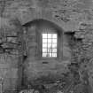
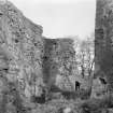
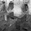
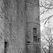
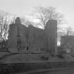
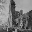
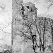
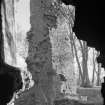
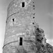
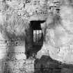
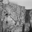
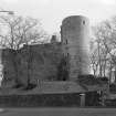
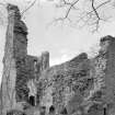
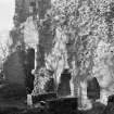
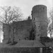
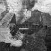
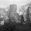
The castle stands on a mound that is largely artificial. It is an oblong building 70 feet by 38 feet, with the long axis running east and west. There is a round tower, four storeys high, at the north-west angle and a projecting wing at the south- east corner.
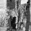
The castle itself was three storeys high and the north and east walls still stand, with the central part of the south and the lower part of the west walls.
J A Wilson 1936.
Avondale Castle seems to have been built in the fifteenth century.
D MacGibbon and T Ross 1887.
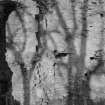
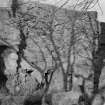
Strathaven Castle (Lanark Co. Council noticeboard). The castle is generally as described by Wilson. It is constructed of rubble masonry, the lower parts of the walls showing signs of coursing, and the remains are in fair condition.
Visited by OS (JD) 17 March 1955.
NS 7033 4444. A watching brief was carried out on behalf of the District Council during environmental improvement works in the area around the remains of Strathaven, or Avondale Castle. The castle and the park area around it on the E bank of the Powmillon Burn are Scheduled, and the watching brief was a condition of the Scheduled Monument Consent.
Landscaping operations on the W side of the Powmillon Burn were restricted to the upper, modern deposits at the corner of Todshill Street and The Cross.
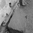
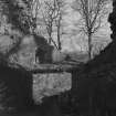
Pathlaying operations at the SE corner of the upstanding remains of the castle uncovered the footings of an enclosing wall at the edge of the steep slope above the bum (NS 7034 4442). The wall was constructed of mortared yellow sandstone rubble, and was c 0.9m wide. The line of the wall seemed to continue that of the existing fragments on the NW corner of the extant tower.
During the erection of seating on the E side of the castle (NS 7037 4444), mortared sandstone rubble was encountered at a depth of 0.55m.
Sponsor: Strathclyde Regional Council.
SRC SMR 1994g.
EXTERNAL REFERENCE
Scottish National Portrait Gallery
Glasgow & Lanarkshire Illustrated, 1910 p.146 - article & photograph
Photographic Survey (December 1959)
Photographic survey by the Scottish National Buildings Record in December 1959.
Photographic Survey (September 1959 - December 1959)
Photographic survey by the Scottish National Buildings Record/Ministry of Works in 1959.
Publication Account (1983)
Little is known of the early history of Strathaven castle. The Flemings of Biggar received the barony of Avondale in the twelfth century, and although there is a district called Flemington on the Hamilton road, it is unknown whether the family built a castle at Strathaven. In the following century the barony passed to the Baird family, who maintained it until after the Wars of Independence. It appears that in 1370 Avondale was granted to the Earls of Douglas who might have strengthened an existing castle (Anon, 1879, 5).
Strathaven Castle was reputedly taken and destroyed by James II on the forfeiture of the Douglases in 1455 (Brown, 1947, 102). It was possible Andrew Stewart, who was later granted the barony, had the castle rebuilt and refurbished in the late fifteenth century. During the reign of James V (1513-42), the barony passed into the hands of the Dukes of Hamilton and one member of that family apparently strengthened and enlarged the structure in 1643 (Brown, 1947, 102). After 1716 the castle fell into disuse and was damaged both by lightning in 1737 and, later, quarrying by the townspeople (Brown, 1947, 103-4). In the early nineteenth century it was observed that 'the castle was in a ruinous state and served to be the habitation of martins and swallows' (Mack, 1911, 21).
The ruins of the castle of Strathaven occupy a dominant position in the centre of the town. The castle was apparently designed on the plan of a parallelogram with two towers diagonally opposite. One of the towers still remains on the north-west angle overlooking the town (MacGibbon and Ross, 1971, i, 352), and other surviving fragments include part of the outer wall.
Information from ‘Historic Strathaven: The Archaeological Implications of Development’ (1983).

