
Pennel Burn, Iron Mine


Haematite Mine (18th Century) - (20th Century), Spoil Heap(S) (18th Century) - (20th Century), Tramway(S) (Modern)
Site Name Pennel Burn, Iron Mine
Classification Haematite Mine (18th Century) - (20th Century), Spoil Heap(S) (18th Century) - (20th Century), Tramway(S) (Modern)
Canmore ID 44744
Site Number NS62NW 13
NGR NS 603 297
Datum OSGB36 - NGR
Permalink http://canmore.org.uk/site/44744


- Council East Ayrshire
- Parish Sorn
- Former Region Strathclyde
- Former District Cumnock And Doon Valley
- Former County Ayrshire
NS62NW 13 603 297
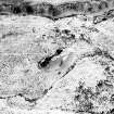
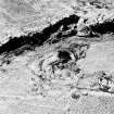
Old iron-ore mine. The shaft has collapsed and there are spoil heaps all around.
Visited by OS (JM) 20 April 1978.
An archaeological survey of part of a haematite mine was carried out in response to a proposed forestry scheme. The main concentration of mining features lay to the E of the Pennel Burn outside the survey area.
There were two main areas of activity on the W side. A number of mine shafts lie immediately north of a number of industrial features grouped around the terminus of a linear plane or track leading down to the main road. Further down the hillside is a single massive spoil heap beside two large settling tanks and associated with other mining structures. The remains seem to belong to a late 19th century expansion or reworking of mines which used to supply the Terroch foundry, three miles to the SE, in the 18th century. (also falls in Sorn parish)
Sponsor: Historic Scotland
CFA 1991ab.
(Location cited as NS602299) Auchenlongford Haematite Mine: William Baird and Company (Lugar and Muirkirk Ironworks) worked the W side of Pennel Burn, while the Dalmellington and Collins Iron Companies working the E side. According to the Grampian Speleological Group, the plan of Mine No.1 shows two working veins. There are currently visible, one shaft on the W bank of the burn with one level visible on the E bank. The latter is 30 imperial feet and comes to a dead end and was abandoned in December 1882 (Home Office Plans of Abandoned Mines, No. 1436, deposited by W Baird and Co.). A visit in 1999 showed that this mine was indeed closed.
Grampian Speleological Group 2008.
Field Visit (March 1991)
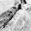
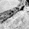
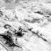
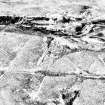
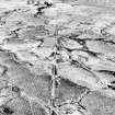
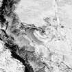
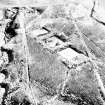
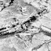
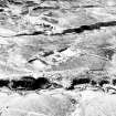
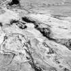
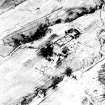
Old mine workings extend for a distance of about 500m downstream from Pennelburn Linn, indeed the gorge through which the burn flows is largely the result of opencast extraction. The principal features of the workings are: the gorge itself; a series of discreet spoil tips lying to either side of the gorge; two sets of settling tanks; the footings of several buildings associated with the mining operations; and the engineered tram-roads leading down to the public roads.
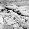
The gorge is an imposing feature, in places measuring in excess of 40m in width and some 15m in depth. For the most part, its SW side is simply a steep scarp, but much of the NE side is marked by cliffs of bare rock, all of them stained dark red by the haematite. Most of the spoil from operations within the gorge appears to have been deposited in the bottom, which is choked with discarded debris. To enable these operations to take place, the miners must have managed the burn and there is evidence of a built stream channel extending for a distance of 160m downstream from a small dam within the gorge.
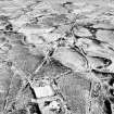
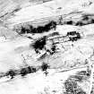
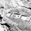
Access to the workings within the gorge was from a spur of a tram-road on the E side of the Pennel Burn. The tram-road enters the mouth of the gorge between a "crow's foot" spoil heap and a small conical heap. This is also where there are the footings of a building which is depicted as roofed on the 1st edition of the Ordnance Survey 6-inch map (Ayrshire) 1860, sheet 30; the building has two compartments and measures 25.5m by 6.1m over clay-bonded walls up to 1m in height. Two other spurs of the tram-road continue up the hill, heading for a point on the edge of the gorge opposite a large conical spoil heap. A setting of bolts here, a small square foundation and a general mess resulting from demolition activities, suggest that this was some kind of minehead, either for the opencast workings or for a shaft. The tram-road on this side of the gorge, however, was also servicing some workings to the NE, whose most prominent feature is a large "crow's foot" spoil tip. These workings appear to be quite small scale, exploiting outcrops on the hillside, but at one point a trench has been driven into the rock face and partially backfilled with its own spoil. The "crow's foot" spoil tip is more suggestive of a shaft than these minor workings, although no trace of one is now visible.
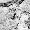
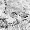
The large conical heap to the W of the gorge has been superimposed upon three curving tip runs, which extend from the brick-lined mouth of a partly filled shaft. Although traces of two buildings can be detected, the minehead has been deliberately demolished, and the circular structure at the foot of the conical heap may be no more than a brick-built sheepfold. A heap of ash and clinker beside the tram-road to the SSE of this shaft may well indicate the presence of the steam powered lifting gear. To the N of the shaft, along the edge of the gorge, there is a series of large pits which are probably the result of subsidence, and a possible pond. A curious feature of the tip runs at this mine are the bricks that have been laid into them at various points. This is not a feature that has been noted elsewhere around Muirkirk but may be related to the establishment of a conveyor to create the conical heap.
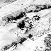
To the SSE of this mine, and to the W of the mouth of the gorge, there is another "crow's foot" spoil heap, but in this case the origin of the material is not clear. A row of cottages lies immediately to the NW, with traces of what may be another building a little further W again, and to the SW of the heap there are also two large settling tanks. In all, there are five settling tanks, the other three lying to the E of the Pennel Burn. The latter are all square and are stepped down a gentle slope. It is by no means clear whether the tanks were used to prevent waste from the mine from entering the streams and rivers or whether they played some part in the process of extracting the haematite from the ore.
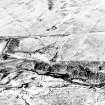
An impressive feature of the exploitation of the haematite deposits along the Pennel Burn is the construction of the tram-roads linking the mine to the system of public roads. Engineered with cuttings and embankments to create gentle inclines, they traverse distances of 1.7km, 2.4km and 2.8km respectively in straight lines across the moorland to the S of the mine. The westernmost extends SSE from the minehead on the W side of the gorge and eventually meets the public road (B743) 1.2km W of North Limmerhaugh (NS 605 271). To the E of the mine the tram-roads braid to pass either side of the settling tanks, but to the SE they also split into two, with one branch running straight down to the minor road leading to Nether Whitehaugh (NS 617 288) and the other to the top of the escarpment above North Limmerhaugh (NS 616 270). How the ore was transferred to the road at this point is not known, for there are only the faintest traces of a track dropping down the slope to the back of the farm. To the W, however, separated from the main tram-road by a deep gully, there is a terraced track of similar character to the tram-road running obliquely down to the road (NS 615 268).
The chronology of the various elements of the workings are not certain. The haematite deposits, however, are known to have been worked in the eighteenth century and also in the 1850's and late 1880's. An "Iron Mine" is depicted here on a county map of 1775 (Armstrong 1775), while the 1st edition of the Ordnance Survey 6-inch map marks an old ironstone mine in the gorge (Ayrshire) 1860, sheet xxv). The 2nd edition of the map (ibid 1897) depicts all the big spoil heaps in the vicinity of the gorge but the absence of any of the tram-roads; the row of cottages and the settling tanks also points to a later period of exploitation in the present century.
Visited by RCAHMS (SPH) March 1991.

