
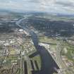
Glasgow, 18 Clydebrae Street, Govan Graving Docks


Dry Dock(S) (19th Century), Graffiti(S) (21st Century), Piece(S) (21st Century), Tag(S) (21st Century), Throw Up(S) (21st Century)
Site Name Glasgow, 18 Clydebrae Street, Govan Graving Docks
Classification Dry Dock(S) (19th Century), Graffiti(S) (21st Century), Piece(S) (21st Century), Tag(S) (21st Century), Throw Up(S) (21st Century)
Alternative Name(s) Govan Dry Docks; Stag Street; Govan Road; River Clyde; Lower Harbour
Canmore ID 68406
Site Number NS56NE 118
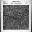
NGR NS 56090 65463
NGR Description Centred NS 56090 65463
Datum OSGB36 - NGR
Permalink http://canmore.org.uk/site/68406


First 100 images shown. See the Collections panel (below) for a link to all digital images.
- Council Glasgow, City Of
- Parish Govan (City Of Glasgow)
- Former Region Strathclyde
- Former District City Of Glasgow
- Former County Lanarkshire
Govan Graving Docks, Stag Street, 1869, 1883, 1894, James Deas
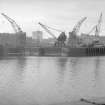
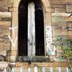
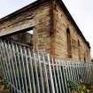
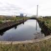
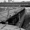
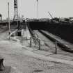
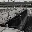
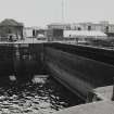
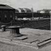
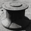
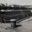
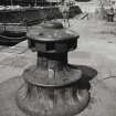
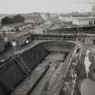
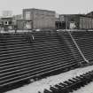
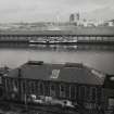
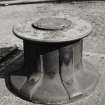
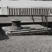
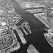
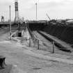
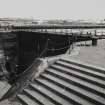
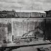
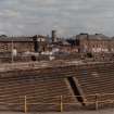
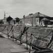
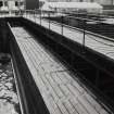
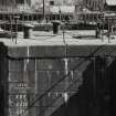
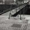
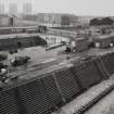
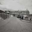
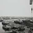
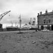
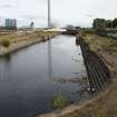
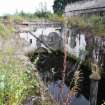
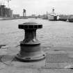
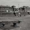
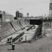
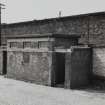
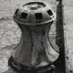
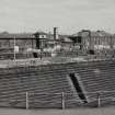
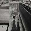
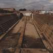
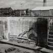
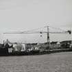
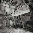
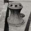
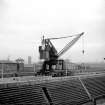
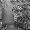
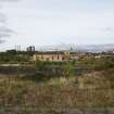
Outstanding complex, unique in Scotland, comprising three dry docks and associated quays. The longest dock (1894) - 268m (880ft) long, 25m (83ft) wide and 8m (26.5ft) deep - held the largest vessels afloat or could be divided to take two smaller vessels. Dock bases and ground surfaced with heavy-duty whinstone setts. Dock walls, stepped sides and quay edges built to last in grey granite. Retaining walls and ramp sides in white sandstone. Workshops in ashlar or polychrome brick. Dock equipment of steel caisson gates, two with folding bridges, hydraulic capstans at dock entrances, bollards, hydraulic pump and sluice houses. Scotch derrick crane, A & W Smith. An 1889 weighbridge. Closed, minor buildings deteriorating, awaiting new use.
Taken from "Greater Glasgow: An Illustrated Architectural Guide", by Sam Small, 2008. Published by the Rutland Press http://www.rias.org.uk

NS56NE 118.00 centred 56090 65463
Not to be confused with Prince's Dock (adjacent to SE), for which see NS56SE 87.00.
NS56NE 118.01 NS 56122 65499 Graving Dock No. 1
NS56NE 118.02 NS 56107 65456 Graving Dock No. 2
NS56NE 118.03 NS 56120 65364 Graving Dock No. 3
Govan Graving Docks, Stag Street, built 1869-98 for the Clyde Navigation Trust.
The first [NS56NE 118.01: Graving Dock No. 1], nearest the river, was constructed between 1869 and 1875, and is 551ft [168m] long, 72ft [22m] wide, with a depth of 22ft 10ins [6.9m] at high tide.
The second [NS56NE 118.02: Graving Dock No. 2] was opened on 13 October 1886, and is 575ft [175.3m] long, 67ft [20.4m] wide, and the same depth as No. 1.
The third [NS56NE 118.03: Graving Dock No. 3] is largest, and measures 880ft [268.3m], 83ft [25.3m] wide, and 26ft 6ins [8.1m] deep. When opened, on 27 April 1898, it could take the largest vessels afloat.
No. 1 had, until 1970, a fine steam travelling crane, the last of its type in the harbour.
J R Hume 1974.
(Location cited as NS 561 654). Govan Graving Docks, Stag street, built 1869-98 for the Clyde Navigation Trust. Three large graving docks, each of which could, when built, take the largest ships afloat.
J R Hume 1976.
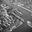
This group of dry docks occupies a slight projection from the S bank of the River Clyde within the area of the Lower Harbour and to the NW of Prince's Dock (NS56SE 87.00). Access to No. 3 has been gained by manouvering ships through the canting basin NS56NE 4920.
The 1983 edition of the OS 1:1250 map notes an El Sub Sta [NAT] at NS 56205 65283, to the SW of the entrance-gate to No. 3 dock. Its situation and comparison with other docks, suggest that this building was originally a hydraulic power station, installed to power the lock gates and other machinery.
Information from RCAHMS (RJCM), 15 February 2006.
An outstanding graving dock complex without parallel in Scotland. 3 major dry docks, associated quays, capstans and bollards, pumphouses, workshops and other ancillary buildings, retaining and boundary walls, ramped accesses and stairs. The dock walls and quay edges are of grey granite, the working surfaces whinstone setted, and retaining walls and ramp sides are of cream sandstone. Cast-iron gatepiers.
Built for the Clyde Navigation Trust during the years when the Clyde yards led the world in the building of sophisticated merchant ships, so the complex is of architectural/historic interest in an international context, of major significance in terms of the history of the world shipbuilding. Docks Nos 1 and 3 were each the deepest in Britain when built and could take the largest ships afloat.(Historic Scotland)
Watching Brief (8 June 2016 - 10 June 2016)
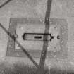
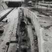
NS 56090 65463 A watching brief was undertaken, 8–10 June 2016, during ground investigation work at Govan Graving Docks. The work focused on the area around three former graving docks and their associated structures, all protected as a Category A listed building (LB33336). A series of 16 test pits was excavated and distinct structural features were noted in five of them. All of the features appeared to relate to the graving docks and took the form of various brick, sandstone and concrete walls and surfaces.
Archive: NRHE intended
Funder: New City Vision Ltd
Steven Black – Northlight Heritage
(Source: DES, Volume 17)
Field Visit (28 September 2017)
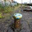
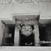
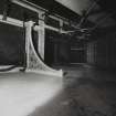
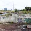
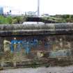
Extensive graffiti, including tags, throw ups and a large roller piece (applied using a paint roller), is visible over all areas of the former graving docks complex.
Visited by HES Survey and Recording (JRS, AMcC) 28 September 2017.

