
Carmunnock, Carnbooth, Netherton Braes


Anti Aircraft Battery (Second World War) - (20th Century) (1939)-(1956), Enclosure (20th Century)
Site Name Carmunnock, Carnbooth, Netherton Braes
Classification Anti Aircraft Battery (Second World War) - (20th Century) (1939)-(1956), Enclosure (20th Century)
Alternative Name(s) Gsg3; S3; Clyde Aa Defences; Clyde Postwar Aa Defences; Mid Netherton
Canmore ID 43809
Site Number NS55NE 18
NGR NS 5827 5751
Datum OSGB36 - NGR
Permalink http://canmore.org.uk/site/43809


- Council Glasgow, City Of
- Parish Carmunnock (City Of Glasgow)
- Former Region Strathclyde
- Former District City Of Glasgow
- Former County Lanarkshire
NS55NE 18 5827 5751.
NS 5827 5751. Impression of a 6m to 7.5m broad bank, enclosing an area 40m in diameter, around a solitary WD building at Netherton Braes.
Information contained in letter from T C Welsh to OS, 9 June 1974.
The location of this enclosure and the description given above makes it very probable that this is one of a series of heavy anti-aircraft batteries which were guarding the approaches to Glasgow and the Clyde Estuary during the Second World War.
Information from J Guy, September 1996
This heavy anti-aircraft position is situated on Netherton Braes and consisted of a four gun-emplacement battery, with the GL mat (gun laying radar false horizon hexagon) to the N. The accommodation camp was to the E. (The gun-emplacements, GL-mat (gun laying radar) and accommodation camp are visible on RAF post-war vertical air photographs, 106G/Scot/UK 140, part III, 5283-4, taken 3 July 1946).
Information from RCAHMS (DE) July 1997.
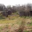
NS 5833 5756. This World War II heavy anti-aircraft battery is situated at the end of a rough track leading from the cemetery at Mid Netherton.
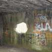
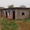
Four brick and concrete gun-emplacements, command post, two magazines, gun store, engine room and one computing room all survive in a field. The hut bases for the crew accommodation camp are still visible to the E.
J Guy 2001; NMRS MS 810/11, Part 3, 211-12; Vol.2 (appendix), 19-21
This battery would appear to have some postwar alterations and following information supplied by Mr Bamber (information via e-mail to RCAHMS from Mr J Bamber, 3 July 2008), an examination of post 1946 air photography was undertaken
Vertical aerial photography subsequent to the 1946 sortie above (ibid) and recent oblique aerial views (RCAHMS 2007) show that additional buildings were constructed sometime between 1950 and 1954. Sortie 541/A/527, frames 3063-3064, flown 13 May 1950 shows that the battery had remained unaltered since 1946. The gun-emaplacements, command centre and engine room set within a barbed wire enclosure along with the accommodation camp all remain in situ. By the date of the 1954 sortie (F22 540/RAF/1485, frames 0040-0042, flown 24 November 1954), however, show that two buildings with a made track from the road to the gun emplacements had been added on the SW of the barbed wire enclosure with a second falt roofed structure on the SE side. Within the accommodation camp, at least six huts had been removed, but two small square pitched roofed huts had been added at the NE end. The oblique air photography by RCAHMS would appear to confirm these changes with the presence of a single flat roofed building to the SW with anoter to the SE.
The additional buildings suggest that some postwar work was undertaken at this battery, though not on the scale seen at other heavy anti aircraft sites (see NS36NE 32, NS47NW 25 and NS76NE 24).
Information from RCAHMS (DE), July 2008; e-mail from J Bamber, 3 July 2008
Field Visit (16 April 2019)
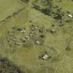
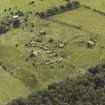
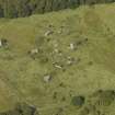
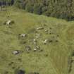
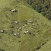
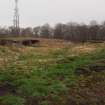
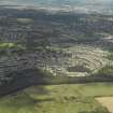
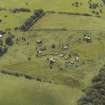
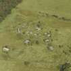
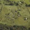
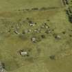
This heavy anti-aircraft battery is situated on a low rise in rough pasture about 700m SW of Carmunnock Cemetery. It comprises four gun emplacements, a command post, two magazines, a gun store and a metalled service road constructed during the Second World War, while a new command post, an engine house and security fences were added during the Cold War. The remains of the camp, which are now reduced to 24 concrete platforms, are situated immediately to the SE of the track, while 13 boundary stones were introduced to define the military zones. This battery was originally one of at least 43 that were constructed to protect the industries in the centre of Glasgow and along the banks of the River Clyde from aerial attack by the Luftwaffe.
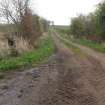
The service road follows the line of an earlier farm track measuring up to 4m wide, which runs for about 925m SW from its junction with Holmbyre Road (NS 58975 58316) about 90m NW of Mid Netherton farm (NS55NE 161), before a branch swings WSW to make for the entrance to the battery. From here the track is lost beneath overgrown dumps of agricultural spoil, but its line can be detected as a grass-grown track after about 75m, as it enters the former gate in the security fence to run between the gun emplacements and the command post.
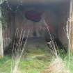
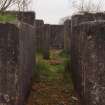
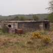
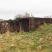
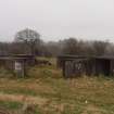
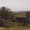
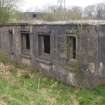
The four gun-pits (NS 58360 57551; NS 58333 57547; NS 58312 57565; NS 58310 57591) are planned around the circumference of a circle with a radius of 34m pivoted on a SW axis. They can be separated into two pairs, one on the W arc of the circle and one on the SSE, but all are of the same design and protected by earthen bunds. Each is a regular octagon, measuring 12.3m in diameter within reinforced cast concrete blast walls 0.34m thick and 1.67m high. A pair of opposed gateways 3.7m broad occupy two of the sides, but the S gate in the SE gun-pit has been blocked by a later extension of the bund (subsequently breached), while the gate terminals in the WSW gun-pit have been destroyed. In addition, roughly rectangular notches measuring about 1.5m wide and 0.3m deep have been crudely broken through the upper section of the blast walls in each gun-pit – on one side in the SE and NW gun-pits and on two opposing sides in the S and W gun-pits. All were originally provided with six ammunition lockers symmetrically arranged against the inner side of the blast wall; but these were demolished during the Cold War reconstruction, leaving a scar against the wall and a single pair of raised concrete floors situated directly opposite one another between two pairs of the replacement lockers. It is possible that the crude breaks in the blast walls were made during their demolition. In their place, four larger open-ended lockers were constructed. Not all survive, but those that do have flat reinforced concrete roofs, raised concrete floors and a short, shuttered concrete wall at one end creating a narrow corridor for access to the broader end. They measure 3.65m long by 1.97 transversely within a wall 0.16m thick and 1.46m high. Their interiors were whitewashed and originally fitted out with wooden racks in three horizontal rows, but only the vertical putlogs now survive. Punctures to the lockers’ thin inward facing walls suggest that some of these racks may have been violently or carelessly removed, but later some were carefully repaired. Inverted triangular plate marks on the blast walls mark the positions of junction boxes between each, while sometimes drainage pipes passing through these walls are visible at ground level at a change of angle. Where not moss- and grass-grown, each concrete hardstanding enclosed by these structures can be seen to have had a circular arrangement of upright bolts for the holdfast measuring 2.15m in diameter at its centre. A cable duct from the centre of the holdfast runs under one locker and into an engine house attached to the exterior of the blast wall. These engine houses are rectangular on plan and measure 3.67m by 2.43m within reinforced cast concrete whitewashed walls 0.32m thick and 1.75m high. They have flat concrete roofs and some retain the iron frames of the double doorways facing on to the service road. Inside they contain a single central plinth for a generator with broad cable ducts to either side. A crew shelter is also attached to the exterior of the blast wall of the SE, NW and W gun-pits, although that provided for the latter has been partly demolished. These are also rectangular on plan and measure 4.6m by 2.76m within whitewashed brick walls 0.36m thick and 1.75m high. They have flat overhanging roofs, a doorway offset to one side at one end providing access to the interior and a small central vent situated high in their back walls. This vent is used by a crude brick chimney-breast with a fireplace below, which has been built against the back wall of the shelter in the NW gun-pit. Unusually, a small store, measuring 2.15m by 1.3m within reinforced cast concrete walls 0.24m thick and 1.55m high, has been constructed against the exterior of the blast wall of the SSW gun-pit. This has a flat roof and a doorway facing NW retaining only its iron frame.
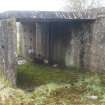
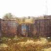
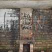
The rear gate of each gun-pit pair leads to a neatly kerbed, grass-grown concrete path running down in a curve to a shared magazine, which is centrally situated about 10m to their rear, while a third path bisecting each pair leads directly from the service road to the central entrance of the magazine. These are rectangular on plan and measure 11.15m by 3.7m transversely within reinforced concrete and cement-skimmed brick walls 0.11m or 0.33m thick and 2.75m high. They have flat overhanging concrete roofs and their facades are divided into five bays by six narrow rectangular pilasters. This is broken by three symmetrically arranged entrances, while a window with a cast concrete sill is situated either side of the central doorway. What appears to be an additional window has been crudely knocked through the S gable of the W magazine and the W gable of the S magazine. Internally, a passage runs the length of the building providing access to five compartments, of which the outer and central compartments have been provided with circular vents in the roof. Each of these compartments has been identified by a number painted in white within a black square and one in the S magazine has ‘Recess’ clearly stencilled below. Another stencilled notice on a dark background sited adjacent to the number in compartment 4 of this magazine reads, ‘Batch No | Nature | Let: | Total Rds’. In addition, a tally board with three columns headed ‘Date’, ‘Front’, ‘Rear’ has been stencilled in red on the rear of the façade in the corridor.
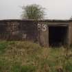
The gun store (NS 58304 57533) is situated midway between the magazines and about 50m SW of the Second World War command post. It is rectangular on plan and measures 7.66m from NE to SW by 6.13m transversely within reinforced cast concrete walls 0.33m thick and 2.42m high. The flat, overhanging roof of reinforced concrete extends over a shallow outshot on the SW adjacent to the S corner of the building and the entrance to the latter is surmounted by a cast concrete lintel. A wider entrance, again surmounted by a cast concrete lintel, is positioned off-centre in the NE wall adjacent to the building’s N corner. Although the NW side of the building is entirely plain, a crude, roughly rectangular aperture has been punched through it. By contrast, the SE wall features four windows, two which are narrow and rectangular, flanking two broad and square, all with a cast concrete lintel and sill. The interior contains a single compartment with a single circular vent in the roof. The latter has been strengthened with iron beams that span the width of the building.
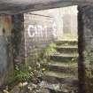
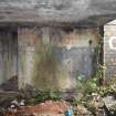
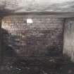
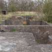
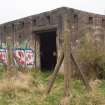
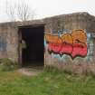
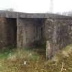
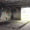
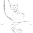
The Second World War command post (NS 58342 57574), which is situated immediately NE of the service road, is deeply buried within a broad grass-grown bund. It contains four compartments arranged around a central core, with three interlinked, open air, rectangular concrete enclosures attached on the NW for the height finder, the predictor and the spotting telescope, which are located on the ground surface above. The overhanging, bitumen-clad, reinforced cast concrete roof above the compartments protects a series rectangular windows with concrete sills and small vents positioned between it and the bund. Access to the interior is provided by five flights of steps situated on the W, ENE, N, NNW and NW sides of the building, although the last pair conjoin and use the same entrance. All the rooms are strewn with debris, but the largest measures 9.15m from NW to SE by 3.06m transversely and 2.15m high within three whitewashed brick walls. These are internally lined against damp with bitumen, but the fourth wall on the NW is of shuttered concrete, reflecting the construction of the adjacent room. Doors lead out from the largest room not only to each of its smaller neighbours, but also to the SW enclosure on the terrace above. The small enclosure that held the predictor retains its central pillar set in a circular foundation block.
No trace remains of the gun laying radar which is visible upon aerial photographs taken in 1941 (M/103/F309/3646 and M/106b/A309/03671). It was situated at the centre of a GL mat immediately NE of the battery,
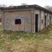
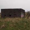
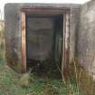
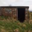
The Cold War command post (NS 58251 57507) is situated about 100m SW of its predecessor and is closely confined within a ruined security fence comprising cast concrete posts. This enclosure is entered through a gate on the SE close to the E corner. The building, which is rectangular on plan and has a flat roof, measures 12.06m from NW to SE by 6.1m transversely within reinforced concrete walls about 0.3m thick and 2.42m high. A door retaining its iron frame and protected by a cast concrete lintel is situated in the centre of the SE façade, between a single rectangular vent each side situated immediately below the flat concrete roof. This contrasts with the NW elevation, where a concrete ramp approaches a central double door, also protected by a cast concrete lintel and retaining its iron doorframe. The NE elevation contains a single window in the SE half protected by a similar lintel, but its sheet metal shutters are missing; while a large hole punched through the wall to the NE has not broached the reinforcing mesh of steel rods. A rectangular inspection pit is situated against the wall on the ground between them. The opposite elevation on the SW is plainer, but there is another inspection pit and two small, discrete, ruined outshots located at the W corner. The interior of the main building is divided into two compartments, but although there are vents in the walls and the floor of the NW compartment has a series of ducts, both have been stripped of their fittings.
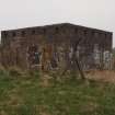
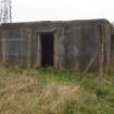
The engine house (NS 58355 57500), which provided the electricity for the guns and other operational systems, is situated 93m E of the Cold War command post and 66m SSE of its predecessor. It is also surrounded by its own ruined security fence. The building, which is almost square on plan and has a flat roof, measures 7m from NNW to SSE by 6.7m transversely within reinforced cast concrete walls about 0.3m thick and 3.05m high. The NNW façade is not only distinguished by double doors surmounted by a cast concrete lintel adjacent to the NW corner, but also five equally spaced rectangular vents immediately below the flat roof. Six similar vents occur in the same position on the WSW side, with a small square aperture at ground level and five on the SSE side. By contrast there are three tall rectangular vents with iron louvres located about 0.6m above the ground surface on the ENE side, with three smaller square vents immediately above each off-centred to the SSE. Again, no fittings survive within the interior, which appears to have been blackwashed.
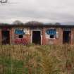
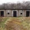
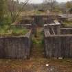
What remains of the camp which served the battery during both the Second World War and the Cold War, is situated immediately SE of the old farm track in the field opposite, where the concrete floors of at least 20 rectangular wooden buildings are visible (NS 58569 57530; NS 58496 57540; NS 58506 57532; NS 58519 57526; NS 58478 57511; NS 58486 57498; NS 58499 57495; NS 58440 57504; NS 58450 57489; NS 58461 57482; NS 58439 57474; NS 58450 57467; NS 58430 57462 (partly covered by a later timber-built shed with a roof of corrugated iron sheeting); NS 58441 57453; NS 58421 57447; NS 58431 57440; NS 58411 57433; NS 58389 57437; NS 58335 57370) - including one that shares a party wall (NS 58538 57516). Their footprints vary from 6.5m to 21m in length and from 4.2m to 7.7m in breadth. Most are moss- and grass-grown, and while some are raised on brick foundations, at least one was set upon low, square concrete posts. In another instance, the foundation has been laid with wide spaces between each brick (NS 58536 57514) – perhaps a measure adopted due to scarcity. A further foundation may have been provided for a tank (NS 58404 57458), while a concrete cistern (NS 58528 57336), with two dislodged inspection covers on its summit and an open drain at each end, is situated at the edge of the woodland enclosing an unnamed tributary of the Kettoch Water. This measures 6.6mm from NNE to SSW by 2.5m transversely rising 0.3m above the ground surface; while 3.3m to its W is a low enclosure (NS 58521 57339) with a grass-grown interior, measuring 6.5m from NNE to SSW by 4.5m transversely, within brick walls 0.35m high. Further drains and inspection covers associated with the water supply are scattered throughout the camp.
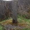
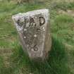
The perimeter of the battery and the camp is demarcated by a series of War Department boundary stones. These are cast concrete pillars, roughly triangular on plan, with a flat back and a sloping top bearing an impressed ‘W’ and ‘D’ on either side of an upward pointing arrow with the letters ‘BS’ and a number below. The following were located: 2 (NS 58471 57579), 3 (NS 58493 57606), 5 (NS 58529 57447), 6, (NS 58487 57470), 7 (NS 58385 57330), 8 (NS 58166 57427), 9 (NS58295 57679), 10 (NS 58503 57293), 11 (NS 58485 57307), 12 (NS 58522 57354), 13 (NS 58544 57339).
Visited by HES, Survey and Recording (ATW, AKK, AMcC), 16 April 2019.
Measured Survey (16 April 2019)
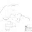
HES surveyed the command post at Carmunnock heavy anti-aircraft battery on 16 April 2019, collecting GPS linework and a producing a measured sketch. The GPS linework, sketch plan and photographs were used to create a ground and floor plan in vector graphics software at a scale of 1:200.

