
Catrine Mill, Water Works, Lade, Sluices And Ponds


Lade (Period Unassigned), Pond(S) (Period Unassigned), Sluice(S) (Period Unassigned)
Site Name Catrine Mill, Water Works, Lade, Sluices And Ponds
Classification Lade (Period Unassigned), Pond(S) (Period Unassigned), Sluice(S) (Period Unassigned)
Alternative Name(s) '30m S Of 9 St Cuthbert's Street'; 'water Works For Catrine Mills'
Canmore ID 73797
Site Number NS52NW 19.02
NGR NS 53549 26216
NGR Description NS 53549 26216 to NS c. 52748 25954
Datum OSGB36 - NGR
Permalink http://canmore.org.uk/site/73797


- Council East Ayrshire
- Parish Sorn
- Former Region Strathclyde
- Former District Cumnock And Doon Valley
- Former County Ayrshire
NS52NW 30 5353 2617 to 5275 2596.
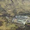
The water supply system for Catrine Mill from the River Ayr follows an irregular course with basins, channels and a covered lade.
Information from Historic Scotland, May 1993.
The aquaduct photographed by J R Hume is recorded as lying behinf No.s 12 and 14 Mill Street
Information from RCAHMS (SDC) 7.11.2000
Watching Brief (6 July 2009 - 16 July 2009)
NS 533 260 A watching brief was undertaken from 6–16 July 2009, on ground-breaking works associated with the redirection of a gas main in the area of a lade (scheduled ancient monument) associated with Catrine Mill in
St Cuthbert’s Street. During these works part of the roof of the covered lade was identified and all ground-breaking works were then diverted around any subsurface built structures.
Archive: RCAHMS (intended)
Funder: Scotia Gas Network
Victoria Clements – AOC Archaeology Group
External Reference (22 August 2011)
Scheduled (with NS52NW 190.01) as 'Catrine, water works for Catrine Mill 30m S of 9 St Cuthbert's Street... the water management system that was built and developed to supply water power to Catrine's cotton mills and bleaching works. The main elements are a a weir [NS52NW 19.01] on the River Ayr, five large ponds known as 'voes', and a series of open and covered lades. There are also the remains of sluices and the foundations of a short aqueduct that carried water from the end of the lade to the wheelhouse. The water management system lies on the north side of Catrine, beginning at the River Ayr to the north-east of the town and extending westwards for almost 1km to terminate about 85m NNW of Mill Square. The first parts of the system were built in 1787, but it was adapted several times before its eventual disuse in the 1970's.'
Information from Historic Scotland, scheduling document dated 22 August 2011.
Note (31 August 2011)
Formerly entered as NS52NW 30 at cited location NS 531 260 (NS 5353 2617 to NS 5275 2596).
(Re-entered as NS52NW 19.02 at cited location NS 53549 26216 to c. 52748 25954). The location (extent) assigned to this record is derived from that indicated on the map attached to the HS scheduling document dated 22 August 2011. This does not indicate the route by and location at which the tail-race rejoined the River Ayr to the W of the centre of Catrine.
Information from RCAHMS (RJCM), 31 August 2011.

