
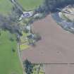
Stair Bridge


Road Bridge (Period Unassigned)
Site Name Stair Bridge
Classification Road Bridge (Period Unassigned)
Alternative Name(s) River Ayr
Canmore ID 42767
Site Number NS42SW 5
NGR NS 43766 23477
Datum OSGB36 - NGR
Permalink http://canmore.org.uk/site/42767


- Council East Ayrshire
- Parish Stair
- Former Region Strathclyde
- Former District Cumnock And Doon Valley
- Former County Ayrshire
NS42SW 5 43766 23477.
(NS 4376 2347) Stair Bridge: A three-span masonry bridge (over the River Ayr), built in 1745.
J R Hume 1976
This bridge is in good repair.
Visited by OS (MJF) 20 October 1980.
Stair Bridge is depicted on the 1st edition of the OS 6-inch map (Ayrshire, 1860, sheet xxxiv), the 25-inch (sheet xxxiv.2, ibid) shows the bridge with cutwaters.
The Object Name Book (ONB), describes the bridge as ' A stone bridge of three arches, over the River Ayr; on a turnpike road. Built and kept in repair by the County. Constructed in 1774' (Name Book 1857).
Information from RCAHMS (DE), January 2008
NMRS REFERENCE
Built 1745

