
Strathcashell Point, Loch Lomond


Crannog (Iron Age), Logboat (Period Unknown)(Possible)
Site Name Strathcashell Point, Loch Lomond
Classification Crannog (Iron Age), Logboat (Period Unknown)(Possible)
Canmore ID 42531
Site Number NS39SE 11
NGR NS 39454 93086
Datum OSGB36 - NGR
Permalink http://canmore.org.uk/site/42531


- Council Stirling
- Parish Buchanan
- Former Region Central
- Former District Stirling
- Former County Stirlingshire
NS39SE 11 3946 9310
Situated a short distance from Strathcashell Point in Loch Lomond, was an 'artificial island' with large oak timbers, two of which were removed for building purposes in 1714.
W Nimmo 1880; Alex Graham (MS/1724).
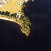
(NS 3946 9309). The crannog is situated in Loch Lomond at a point 450ft E of the Cashell (NS39SE 10), and 30yds offshore. It consists of an artificial mound formed by dumping large boulders, the level top of which measures about 85 ft from E-W by about 65ft transversely. The sides slope down to the bottom of the loch for a vertical distance of about 8ft. Part of a beam could be seen embedded in the boulders.
It is possible to walk round its outer margin with the feet about 3ft below water level and to see the great timbers which are embedded in it. The flat top, about 70ft in diameter, quickly gives way to sloping sides; the depth to which these fall has not been recorded.
RCAHMS 1963; R W Feachem 1963.
All that could be seen of the crannog is a small island c.5.0m in diameter, rising 1.0m above the present level of the loch and surmounted by a few bushes. Traces of a possible causeway can be seen leading from the mainland.
Visited by OS (RD) 9 March 1965
On the day of the survey, the site of Strathcashell crannog was just breaking the surface at the highest point. A small cairn has been built there in the past and so it is not the true top surface of the original site. As at Mill Cairn, the mound is obviously artificial and the top and bottom edges are quite clear except on the W side where they tend
to merge, presumably because of silting. The silting pattern is different from Mill Cairn but presumably that is because of the different positions they have in relation to the adjacent shores. Mill cairn is open to the loch only on the SW, W and NW while Strathcashell is open to the loch everywhere except the N and NE.
A small rectangular feature projects from the bottom of the site towards the shore on the N. While it has the appearance of a small jetty it is too deep to have been one and its purpose is not clear.
Six timbers which all appear to be structural and contemporary with the site were planned at the E end of the top area and one timber projecting from the side of the mound at the E end was also planned but looked modern, with rusted iron fittings. It is worth noting that while all the timbers on the top of the site look structural there is an early photograph of Robert Munro and others at the site which appears in the background and has a tree growing from the top of it. if that is the case, and the picture is not entirely clear, then presumably the remains of that modern tree are also somewhere on the site.
In the shallow water near the shore opposite the E end of the sitre remains of a jetty or breakwater project from the shore SE of the shallows. About 10m to 15m from the end of this in slightly deeper water is a setting of very large stones which may be artificial but whose purpose is unknown. Beside this setting a perforated sandstone, conical object that looks like a loom-weight was discovered. It may, alternatively, be a net-weight but there would be little reason for the conical shape if that was the case.
Another vestigial line of stones leads out from the shallows further E and, in conjunction with the first breakwater could conceivably form a small harbour. However, the remains of stakes in the first breakwater appear relatively modern and there is nothing in all of the features and the crannog to substantiate chronological contemporanity.
On the shore at the W end of Strathcashell Point, there are the remains of a small fortification dating to the Iron Age or the Dark Ages (NS39SE 10). This may be the 'cashel' of Strahcashell Point. All or any of the other features may or may not have been associtaed. Iron bloomery slag was also found in Strathcashell bay, although there is no evidence to suggest that this is contemporary with the crannog.
Mr Ian Orkney of Stirling informed the survey that his mother had a friend who had found the bow of a dugout canoe amongst the stones of Strathcashell in c.1930. The canoe fragment was reportedly removed and taken to the Kelvingrove museum.
The site was also surveyed by the Islay Archaeological Group in 1965. They recorded signs of a building on top, but that no wood or underwater jetties were visible. It seems likely that the 'building' is the cairn noted during the 1997 survey.
STUA and FIRAT (2/1998); NMRS MS 993
NS 394 930 Strathcashell. Distance to shore 37m; diameter 38m; height 3m; depth underwater c 0m. Scheduled Ancient Monument. Structural timbers located. Structural remains, possibly of a harbour in the bay, and iron bloomery slag found in bay. Local information suggests a dug-out canoe found on the site in the 1930s. Modern cairn built on top of the crannog.
Sponsors: Historic Scotland, Friends of Loch Lomond, Loch Lomond Park Authority/SNH, Dunbartonshire Enterprise.
F Baker and N Dixon 1998.
Field Visit (7 July 1955)
N xiii 395 930 (unnoted)
Crannog, Strathcashell Point.
This crannog is situated in Loch Lomond at a point 450 ft. E. of the cashel at Strathcashell Point (No. 164) and 30 yds. offshore. It consists of an artificial mound formed by dumping large boulders, the level top of which measures about 85 ft. from E. to W. by about 65 ft. transversely. The sides slope down for some 8 ft. to the bottom of the loch. At the date of visit most of the mound lay just below the water level, but an area roughly 15ft. in diameter, located a little NE. of the central point, was protruding to a height of about 1 ft. Part of a beam, laid horizontally from NW. to SE., could also be seen embedded in the boulders in the SW. sector at a distance of 15ft. S. of the centre of the crannog.
It was recorded in 1724 (1) that the crannog then had ‘large square joysts of oak firmly mortis'd in one another, two of which of a prodigious bigness, in each of which were three large mortises, were disjoyn'd from the moat in the year 1714 and made use of by a gentleman in that country, who was then building a house’.
RCAHMS 1963, visited 7 July 1955
Field Visit (September 1978)
Loch Lomond, Strathcashell Point NS 394 930 NS39SE 11
This crannog was first recorded in the early 18th century; it consists of boulders and large timbers, some of which are reported to have been squared and jointed with mortices and tenons.
RCAHMS 1979, visited September 1978
(Stuart 1866, 131-2, note; Blundell 1913, 266; RCAHMS 1963, p. 93, no. 107)

