
Port Glasgow, West Quay


Quay (19th Century), Timber Pond (20th Century)
Site Name Port Glasgow, West Quay
Classification Quay (19th Century), Timber Pond (20th Century)
Alternative Name(s) Port Glasgow Harbour; Steamboat Quay
Canmore ID 199787
Site Number NS37SW 150
NGR NS 32290 74660
NGR Description Centred NS 3215 7479
Datum OSGB36 - NGR
Permalink http://canmore.org.uk/site/199787


- Council Inverclyde
- Parish Port Glasgow
- Former Region Strathclyde
- Former District Inverclyde
- Former County Renfrewshire
NS37SW 150.00 centred 3215 7479
NS37SW 150.01 NS 32051 74859 Leading Light (Beacon)
For associated (offshore) Perch Lighthouse (NS 32229 74866), see NS37SW 152.
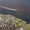
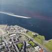
Steamboat Quay [NAT] (centred NS 3198 7496)
OS 1:10,000 map, 1989.
(Location cited as NS 322 748). Port Glasgow Harbour, 19th century. All that is left of this once-important harbour is a stretch of quay on an L plan, with a tapered cast-iron light-tower [NS37SW 150.01]. A short distance off-shore is a reef with a small circular light-tower[NS37SW 152].
J R Hume 1976.
Project (May 2016 - September 2017)
Running from May 2016 to September 2017 and part of the Canmore Mapping Programme, Yard by Yard was an area-focused, desk-based project that tested the Defining Scotland’s Places (DSP) methodology in an area for which the records in the NRHE showed considerable variation from one historic map source to another.
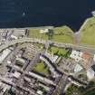
Following discussions with local heritage groups and with the ambition of collecting data useful to the communities’ ambition to develop a coastal heritage trail, the project aimed to map the extent of the shipyards and associated industry between Port Glasgow and Greenock. To achieve this aim, the project used historic mapping, ortho-rectified modern aerial photography and the HES aerial photograph collection to map the extents of, and upgrade the records of, the shipyards and associated features such as quays, docks, areas of land reclamation and associated industry.
Note (6 June 2017)
The harbour of Port Glasgow was built in 1668 as the deep water port for Glasgow, prior to a deep water channel to the city being created in the 18th century. At the same time, a new town was established beside the village of Newark. This new harbour, which is depicted on Roy’s Military Map of Scotland (1747-55), comprised two breakwaters extending NE from the shore and arcing to form a narrow entrance on the NE. The Great Reform Map of Port Glasgow (1832) shows that by that time two piers had been built extending from its SE side into the middle of the harbour, though only the SE one of these survived long enough to be depicted on the 1st edition of the OS 6-inch map (Renfrewshire 1864, Sheet II). The 1832 map also shows that by that time the foreshore to the NW of the harbour had been reclaimed and was then occupied by ‘Mess’rs Scott’s Ship building Yard’. With the growth of nearby Greenock and its harbours, improved navigation of the Clyde, and problems with silting within the harbour at Port Glasgow, trade declined. By 1931 the West Harbour had been partly filled in, a task that was completed in 1936, when a park was created on the site. The eastern part of the harbour was filled in the late 1960s when the main road (A8) was improved and the park enlarged. All that now remains visible of the harbour are the breakwaters on either side of its entrance and waterfront quays on Mirren’s Shore to the NW.
Information from HES, Survey and Recording (AKK) 2 April 2017.

