
Dumbarton, Glasgow Road, Artizan Bridge


Road Bridge (Period Unassigned)
Site Name Dumbarton, Glasgow Road, Artizan Bridge
Classification Road Bridge (Period Unassigned)
Alternative Name(s) River Leven; 'dalreoch Bridge'
Canmore ID 244595
Site Number NS37NE 184
NGR NS 39262 75537
Datum OSGB36 - NGR
Permalink http://canmore.org.uk/site/244595


- Council West Dunbartonshire
- Parish Dumbarton
- Former Region Strathclyde
- Former District Dumbarton
- Former County Dunbartonshire
NS37NE 184 39262 75537
Artizan Bridge [NAT]
OS 1:10,000 map, 1992.
Location formerly entered as NS 39215 75574 to NS 39301 75505.
Not to be confused with (predecessor) Dumbarton Bridge (NS 39268 75358), for which see NS37NE 32.
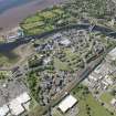
To the N of Bridge Street is the Artizan, a flat riverside site. Redevelopment in the 1960's cleared the ground for the dual carriageway of the A814 leading to the new Artizan Bridge, 1973-4.
F A Walker and F J Sinclair 1992.
Arizan Bridge, 1972-4. A long elegantly understated five-span box-girder carriageway carried on inverted goal-post piers. Designed to take the realigned A814 across the Leven, by Babtie, Shaw and Morton, in consultation with architects Garner, Preston and Strebel.
J Gifford and F A Walker 2002.
This bridge carries Glasgow Road (which here forms the A814) across the River Leven to the W of the town of Dumbarton (NS37NE 30). The river here forms the boundary between the parishes of Cardross (to the W) and Dumbarton (to the E).
This bridgee has been previously entered under the name Dalreoch Bridge; this name should more correctly be applied to the older bridge (NS37NE 32).
The location assigned to this record defines the centre of the span. The available map evidence suggests that the bridge extends from NS c. 39213 75576 to NS c. 39312 75497.
Information from RCAHMS (RJCM), 29 December 2005.

