
Dumbarton, High Street, Riverside Parish Church


Church (19th Century)
Site Name Dumbarton, High Street, Riverside Parish Church
Classification Church (19th Century)
Alternative Name(s) Castle Street; Dumbarton Old Parish Church; St Patrick's Church
Canmore ID 42352
Site Number NS37NE 15
NGR NS 39769 75186
Datum OSGB36 - NGR
Permalink http://canmore.org.uk/site/42352


- Council West Dunbartonshire
- Parish Dumbarton
- Former Region Strathclyde
- Former District Dumbarton
- Former County Dunbartonshire
NS37NE 15.00 39769 75186
Riverside Parish Church [NAT]
OS (GIS) MasterMap, October 2009.
NS37NE 15.01 NS 39729 75191 Churchyard
For (associated) Napier Mausoleum (NS 39801 75188), see NS37NE 181.
See also NS37NE 18.
(NS 3975 7521) The original parish church of Dumbarton is mentioned from the 12th to 14th centuries (G Chalmers 1890), and appears to have been dedicated to St Patrick (Orig Paroch Scot 1850).
It appears to have been rebuilt at least three times. The original church was destroyed towards the end of the 16th century, when it was again rebuilt. The foundations of the old church, and of the pre-Reformation church have been discovered while excavating within the present church built in 1811 on the original site at the south end of High Street.
Orig Paroch Scot 1850; D Macleod 1877; G Chalmers 1890; D MacGibbon and T Ross 1897.
Publication Account (1999)
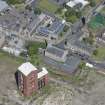
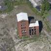
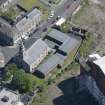
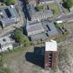
The Riverside Parish Church figure 23.C stands at the east end of the curving High Street, on the site of the medieval parish church, and dates from 1811. Designed by Glasgow architect John Brash, it is a smaller version of his initial plan, the original proving too ornamental and expensive. The church has a simple rectangular plan with a two-stage tower over its west gable. A medieval stone within the church figure 8 and a worn sundial on its south wall may represent older structures incorporated within the current building.
The present building may have preserved traces of at least two earlier phases of the church. A mid eighteenth-century picture figure 7 records a church here, which appears to contain architectural elements of a fourteenth-or fifteenth-century date; and there may have been at least one earlier church on this site. In the seventeenth century, the church is known to have been enlarged, giving a T-shaped plan. It was this structure that was replaced by the 1811 church. Traces of all these earlier churches may be preserved beneath the present floor levels of the existing church and, in particular, more ancient walls may have been re-used as foundations for successive structures. Indeed, traces of earlier structures were noted during construction of the 1811 church. Development would not be expected here, but any ground disturbance in the form of environmental improvements or the insertion or maintenance of services should be archaeologically monitored.
Information from ‘Historic Dumbarton: The Archaeological Implications of Development’ (1999).

