
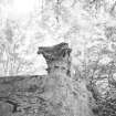
Fullarton Estate, Grotto


Grotto (Post Medieval)
Site Name Fullarton Estate, Grotto
Classification Grotto (Post Medieval)
Alternative Name(s) Fullarton House Policies
Canmore ID 145899
Site Number NS33SW 30.02
NGR NS 34524 30334
Datum OSGB36 - NGR
Permalink http://canmore.org.uk/site/145899


- Council South Ayrshire
- Parish Dundonald (Kyle And Carrick)
- Former Region Strathclyde
- Former District Kyle And Carrick
- Former County Ayrshire
NS33SW 30.02 NS 34524 30334 Fullarton Estate, Grotto
NS33SW 30.00 NS 3451 3021 Fullarton House
NS33SW 30.01 NS 34504 30172 Fullarton Estate, Stable Block
NS33SW 30.03 NS 34228 30089 Fullarton Estate, Pillar
NS33SW 30.04 NS 33982 30672 Fullarton Estate, Saw Mill (demolished)
NS33SW 30.19 NS 3450 3030 Fullarton Estate, North Courtyard Pier
NS33SW 30.20 NS 3450 3030 Fullarton Estate, South Courtyard Pier
NS33SW 7.01 NS 3422 3010 Fullarton House, Ice-House / Remains of Crosbie House
Photographic Survey (June 1965 - February 1966)
Photographic survey by the Scottish National Buildings Record/Ministry of Works in June 1965 and February 1966.

