
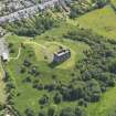
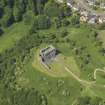
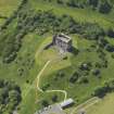
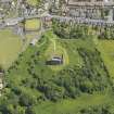
Dundonald Castle


Fort (Period Unassigned)(Possible)
Site Name Dundonald Castle
Classification Fort (Period Unassigned)(Possible)
Canmore ID 41961
Site Number NS33SE 11
NGR NS 3636 3451
Datum OSGB36 - NGR
Permalink http://canmore.org.uk/site/41961


- Council South Ayrshire
- Parish Dundonald (Kyle And Carrick)
- Former Region Strathclyde
- Former District Kyle And Carrick
- Former County Ayrshire
NS33SE 11 3636 3451
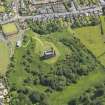
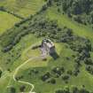
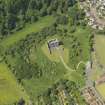
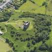
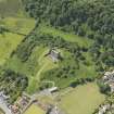
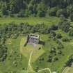
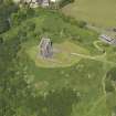
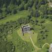
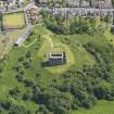
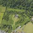
Dundonald Castle (NS33SE 2, at NS 3636 3451) stands within an earthwork which follows the contours of the hill as do the defences of nuclear forts.
L Laing 1975
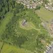
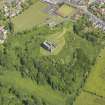
Castle Hill, upon which Dundonald Castle stands, has a prominent summit plateau ideally suited for fortification. However, no perimeter earthworks or walling of pre-Medieval date were noted.
Visited by OS (JRL) 20 May 1982
Although this hill would make a fine location for a fort, all the visible remains are probably associated with the Medieval castle.
Visited by RCAHMS (SH), October 1985.
Note (1 August 2014 - 23 May 2016)
Excavation of Dundonald Castle 1986-93 has not only revealed evidence of Iron Age and Early medieval occupation, but also a length of a vitrified rampart some 4m in thickness lying immediately E of the later barmkin wall, while at the NE corner of the barmkin there was also evidence of a timber palisade; excavation of metalled road surfaces and a groove worn in the bedrock indicated that there was an entrance just S of the length of rampart that was uncovered. Unfortunately the full extent and dates of these earlier defences are unknown, though the presence of E-ware, a glass bead and evidence of metalworking in the assemblage of objects apparently associated with occupation of the interior when the rampart was burnt, suggests that this was a high status site and was probably fortified in at least the the 7th century AD. The assemblage of shale objects, however, is as likely to be Iron Age in date, and the construction of successive round-houses, followed by rectangular buildings, the latter apparently destroyed at the same time as the rampart, attests several periods of occupation when fortifications may have been erected during the 1st millennium BC and the 1st millennium AD. The excavators speculated that occupation on the hilltop had evolved from an Iron Age hillfort into an early medieval dun with a timber-laced wall enclosing about 0.12ha, and the identification of a patch of apparently in situ vitrifaction somewhere to the W of the stone castle led them to propose that the dun had formed a citadel within a larger enclosure, whose circuit was also roughly dictated by the topography of the hilltop. The positions of the two circuits shown on their phased plan of the hilltop (Ewart et al 2004, 28, fig 8) enclose areas of 0.15ha and 0.28ha respectively, but no great reliance can be put upon this interpretation. There are no radiocarbon dates for any of the early features and the use of thermoluminescence on vitrifaction has now been shown to be unreliable, albeit that in this instance it provided a date centred on AD 1000.
Information from An Atlas of Hillforts of Great Britain and Ireland – 23 May 2016. Atlas of Hillforts SC1297
Watching Brief (August 2018)
NS 3636 3451 A watching brief was undertaken, August
2018, at Dundonald Castle during the removal of redundant
floodlighting. No finds or features of archaeological
significance were recorded.
Archive: NRHE (intended). Report: WoSAS
Funder: Historic Environment Scotland
Bethan Gray – CFA Archaeology Ltd
(Source: DES, Volume 19)

