
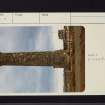
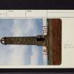
Prestwick, Shaw Monument


Folly (Period Unassigned)
Site Name Prestwick, Shaw Monument
Classification Folly (Period Unassigned)
Alternative Name(s) Prestwick Airport
Canmore ID 41706
Site Number NS32NE 8
NGR NS 36778 26122
Datum OSGB36 - NGR
Permalink http://canmore.org.uk/site/41706


- Council South Ayrshire
- Parish Ayr
- Former Region Strathclyde
- Former District Kyle And Carrick
- Former County Ayrshire
NS32NE 8 36778 26122
(NS 3678 2612) Shaw Monument (NAT)
OS 6" map (1968)
Shaw Monument (NR)
OS 6" map (1911)
The Shaw Monument was probably built in the 18th century (J F W Plascott), by the then laird of Shaw, a keen falconer, in order that he could follow the sport from its top in his old age.
K Hewat 1908; Name Book 1936
This is an unimposing slender round tower, it could be of 18th century date.
Visited by OS (JLD) 11 May 1954
This round tower, some 20m high, of mortored rubble masonry, appears to be a typical 18th century folly. It had a spiral staircase, now gone, and a top viewing platform. Now surrounded by Prestwick Airport development, it is in a dangerous condition.
Visited by OS (JRL) 7 November 1980.

